SUMMARY
This is AI generated summarization, which may have errors. For context, always refer to the full article.
What’s the weather like in your area? Tweet us at @rapplerdotcom.
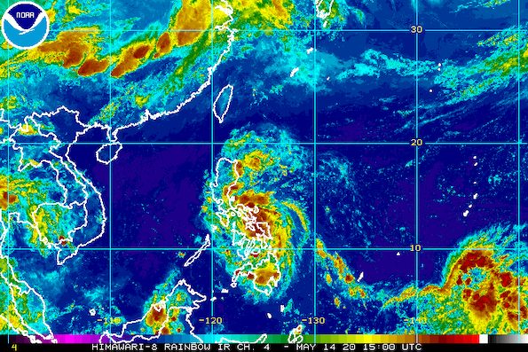
MANILA, Philippines – Typhoon Ambo (Vongfong) weakened after crossing the Samar provinces then began moving over the Ticao Pass, which separates Ticao Island from the Bicol region, late Thursday evening, May 14.
In a bulletin released past 11 pm on Thursday, the Philippine Atmospheric, Geophysical, and Astronomical Services Administration (PAGASA) said Ambo is already 40 kilometers west southwest of Catarman, Northern Samar, or 60 kilometers southeast of Juban, Sorsogon.
It is moving northwest toward Bicol, at the same pace of 15 kilometers per hour (km/h).
“The eyewall region of Typhoon Ambo is bringing violent winds and heavy to intense rain over southern Sorsogon and Ticao Island at this time,” PAGASA said.
The state weather bureau warned that Ambo may make landfall in Albay or in the northern part of Sorsogon in the coming hours. The two provinces are in Bicol.
The typhoon’s first landfall was in San Policarpo, Eastern Samar, at 12:15 pm on Thursday. It crossed Eastern Samar, Samar, and Northern Samar, all provinces located in the Eastern Visayas region.
At the moment, Ambo’s maximum winds are down to 130 km/h from the previous 155 km/h, while its gustiness decreased to 215 km/h from the previous 255 km/h. Tropical cyclones commonly weaken after hitting land, though Ambo, since it is still a typhoon, remains a threat. (READ: FAST FACTS: Tropical cyclones, rainfall advisories)
Areas up north in Luzon are now among those under tropical cyclone wind signals as of 11 pm on Thursday. Some areas, like Metro Manila, are now under higher wind signals as Ambo approaches. Check the updated list below. (READ: Why is it now called tropical cyclone ‘wind’ – and not ‘warning’ – signals?)
Signal No. 3 (winds of 121 to 170 km/h, or strong to destructive typhoon-force winds during the passage of the typhoon)
- Sorsogon
- Albay
- Masbate including Ticao Island and Burias Island
- Catanduanes
- Camarines Sur
- Camarines Norte
- Marinduque
- southern part of Quezon (Pagbilao, Atimonan, Padre Burgos, Agdangan, Plaridel, Unisan, Gumaca, Pitogo, Perez, Alabat, Quezon, Tagkawayan, Calauag, Lopez, Macalelon, General Luna, Catanauan, Buenavista, Guinayangan, Mulanay, San Narciso, San Andres, San Francisco)
- western part of Northern Samar (San Vicente, Capul, San Antonio, Allen, Victoria, San Isidro, Biri, Lavezares, Rosario, San Jose, Bobon, Catarman, Lope de Vega, Mondragon, San Roque, Pambujan, Silvino Lobos)
- northwestern part of Samar (Calbayog City, Sta Margarita, Gandara, Pagsanghan, San Jorge, Tarangnan, Sto Niño, Almagro, Tagapul-an)
Signal No. 2 (winds of 61 to 120 km/h, or strong to damaging gale-/storm-force winds during the passage of the typhoon)
- southern part of Aurora (Dipaculao, Baler, Maria Aurora, San Luis, Dingalan)
- southern part of Nueva Ecija (Bongabon, Laur, Gabaldon, General Tinio, Peñaranda, Gapan City, San Leonardo, San Isidro, Cabiao)
- eastern part of Pampanga (Candaba, San Luis, San Simon, Apalit)
- Bulacan
- Metro Manila
- Cavite
- Batangas
- Laguna
- Rizal
- rest of Quezon
- Romblon
- rest of Northern Samar
- northern part of Eastern Samar (Jipapad, Arteche, San Policarpo, Oras, Maslog, Dolores, Can-avid, Taft, Sulat, San Julian)
- central and northeastern parts of Samar (Matuguinao, San Jose de Buan, Catbalogan City, Jiabong, Motiong, Paranas, Hinabangan, San Sebastian, Zumarraga, Daram, Talalora, Villareal, Pinabacdao, Calbiga)
- Biliran
Signal No. 1 (winds of 30 to 60 km/h, or strong to near-gale-force winds during the passage of the typhoon)
- mainland Cagayan
- Isabela
- Nueva Vizcaya
- Quirino
- Ilocos Norte
- Ilocos Sur
- La Union
- Pangasinan
- Apayao
- Kalinga
- Abra
- Mountain Province
- Ifugao
- Benguet
- Zambales
- Bataan
- Tarlac
- rest of Nueva Ecija
- rest of Pampanga
- rest of Aurora
- Oriental Mindoro
- northern part of Leyte (Calubian, San Isidro, Tabango, Leyte, Capoocan, Carigara, Barugo, San Miguel, Babatngon, Tunga, Alangalang, Sta Fe, Palo, Tacloban City, Jaro, Villaba, Kananga, Matag-ob, Palompon, Merida, Isabel, Ormoc City, Albuera, Pastrana, Dagami, Tanauan, Tabontabon, Tolosa, Burauen, Julita, Dulag)
- rest of Samar
- rest of Eastern Samar
- northeastern part of Capiz (Pilar)
- northeastern part of Iloilo (Carles, Balasan, Estancia, Batad)
- northern part of Cebu (Medellin, Daanbantayan, Madridejos, Bantayan, Santa Fe)
In terms of rain, here’s what to expect from Ambo in the next two days:
Thursday evening, May 14, to Friday evening, May 15
Moderate to heavy rain, with at times intense rain
- Bicol
- Quezon
- Northern Samar
- Marinduque
- Laguna
- Rizal
Friday evening, May 15, to Saturday evening, May 16
Moderate to heavy rain, with at times intense rain
- northern part of Quezon
- Bulacan
- Nueva Ecija
- Aurora
- Nueva Vizcaya
- Quirino
- Isabela
- Cagayan
- Ifugao
- Mountain Province
- Kalinga
- Apayao
- Benguet
Floods, landslides, and even lahar from Mayon Volcano are possible. The Philippine Institute of Volcanology and Seismology issued an advisory on Wednesday, May 13, warning that rainfall from Ambo might mix with volcanic deposits from Mayon’s 2018 eruption, which could result in lahar or volcanic mudflows.
The typhoon may also cause storm surges in the next 24 hours, which might lead to “potentially life-threatening coastal inundation.”
More than 2 meters high
- Catanduanes
- Camarines Sur (north coast, east coast)
- Camarines Norte
- Quezon (coast facing Lamon Bay and Lopez Bay)
Between 1 and 2 meters high
- other coastal areas of Bicol
- other coastal areas of Quezon
- Aurora
- Samar (west coast)
- Northern Samar (northwestern coast)
Sea travel remains risky for all vessels in the seaboards of areas under tropical cyclone wind signals.
Ambo is expected to leave the Philippine Area of Responsibility on Monday, May 18. By then, it is likely to have weakened already into a tropical depression.
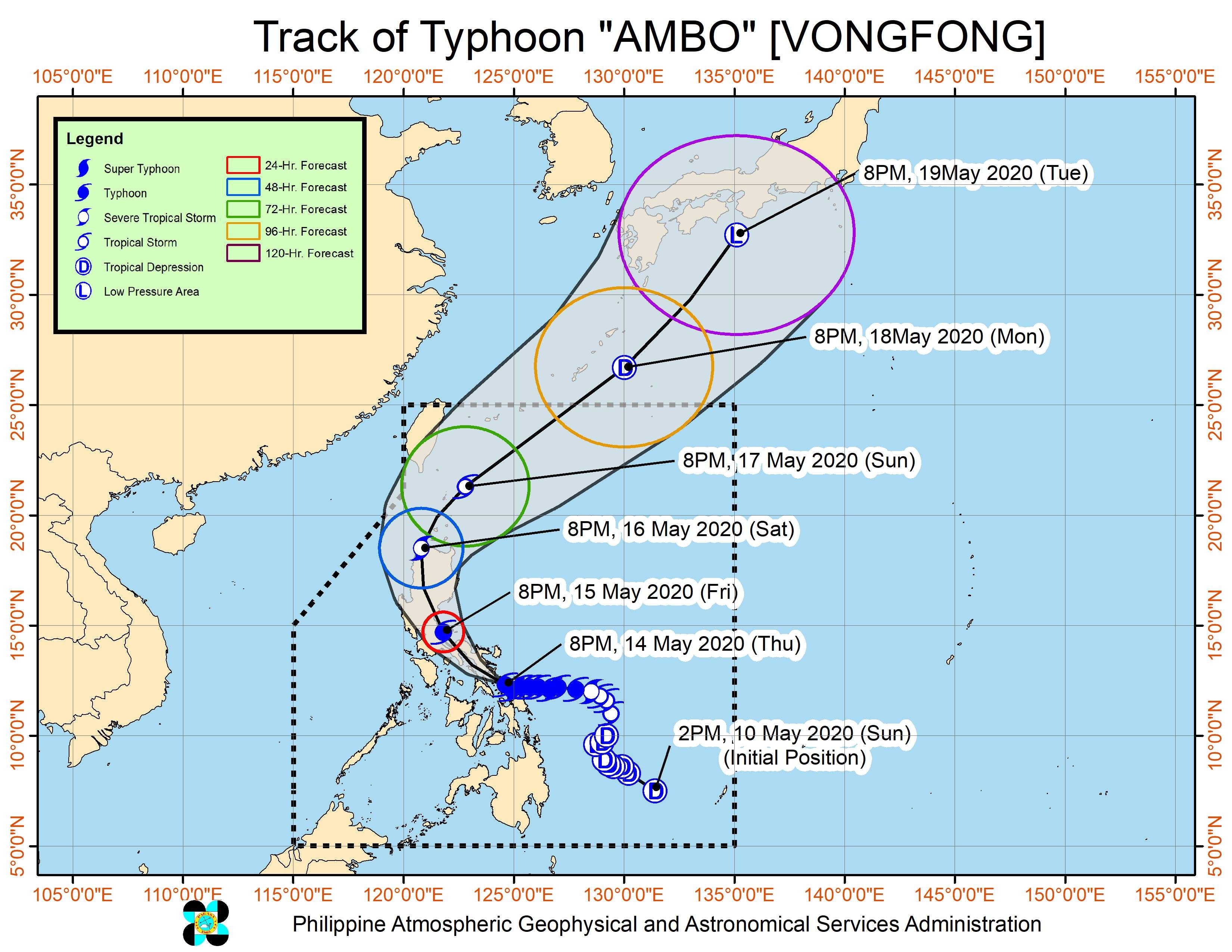
Ambo is the Philippines’ first tropical cyclone for 2020. The country gets an average of 20 tropical cyclones per year. (READ: LIST: PAGASA’s names for tropical cyclones in 2020)
In PAGASA’s climate outlook, it gave the following estimates for the number of tropical cyclones in the next 6 months:
- May – 1 or 2
- June – 1 or 2
- July – 2 to 4
- August – 2 or 3
- September – 2 or 3
- October – 2 or 3
Ambo’s arrival comes as the Philippines faces the coronavirus outbreak, with 11,876 cases as of Thursday. (READ: Social distancing ‘per family’ at Typhoon Ambo evacuation centers) – Rappler.com
Add a comment
How does this make you feel?


There are no comments yet. Add your comment to start the conversation.