SUMMARY
This is AI generated summarization, which may have errors. For context, always refer to the full article.
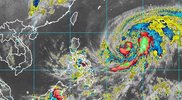
MANILA, Philippines – Agaton (Megi) weakened from a tropical depression into a low pressure area (LPA) on Tuesday evening, April 12, but the state weather bureau warned that heavy rainfall will persist.
The LPA was already over the coastal waters of Guiuan, Eastern Samar, the Philippine Atmospheric, Geophysical, and Astronomical Services Administration (PAGASA) said in its 11 pm bulletin on Tuesday.
It continues to move slowly, however, which means the same areas affected in the past days will see more rain on Wednesday, April 13.
Moderate to heavy rain, with at times intense rain
- Eastern Visayas
- northern and central parts of Cebu including Bantayan and Camotes Islands
- Aklan
- Capiz
- Antique
- Iloilo
- Guimaras
- northern and central parts of Negros Occidental
- northern and central parts of Negros Oriental
- Sorsogon
- Masbate
Light to moderate rain, with at times heavy rain
- rest of Visayas
- rest of Bicol
- Mimaropa
- Quezon
- Dinagat Islands
- Zamboanga del Norte
Since Agaton has weakened into an LPA, there are no more areas under tropical cyclone wind signals. But PAGASA said occasional gusts may still be experienced in these areas:
- Eastern Visayas
- Central Visayas
- Caraga
- Misamis Oriental
- Camiguin
Coastal waters will still be affected on Wednesday as well.
Rough seas
Waves 2.8 to 3.7 meters high; conditions risky for most vessels
- northern and eastern seaboards of Luzon
- eastern seaboards of the Visayas and Mindanao
Moderate to rough seas
Waves 1.2 to 3.1 meters high; conditions risky for small vessels
- southern seaboards of Southern Luzon
- remaining seaboards of the Visayas
- northern and western seaboards of Mindanao
At its peak, Agaton was a tropical storm. It made landfall twice in the Philippines:
- Calicoan Island, Guiuan, Eastern Samar – 7:30 am on Sunday, April 10 (as a tropical storm)
- Basey, Samar – 4 pm on Monday, April 11 (as a tropical depression)

The LPA is expected to finally move east toward the Philippine Sea, away from the Samar-Leyte area, where it has lingered for days and triggered massive floods. Just in Baybay City, Leyte, the death toll has risen to 36, the local government said on Tuesday.
After moving away from landmass, the LPA could merge with Typhoon Basyang (Malakas), which left the Philippine Area of Responsibility (PAR) at 1 pm on Tuesday after just a 3-hour stay.
Basyang was located 1,490 kilometers east of Central Luzon late Tuesday evening, continuing to move away from PAR.
Agaton and Basyang are the Philippines’ first and second tropical cyclones for 2022. While tropical cyclones are not as frequent during the dry season, they do occur. – Rappler.com
Add a comment
How does this make you feel?


There are no comments yet. Add your comment to start the conversation.