SUMMARY
This is AI generated summarization, which may have errors. For context, always refer to the full article.
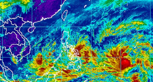
MANILA, Philippines – Tropical Depression Agaton remained almost stationary over the eastern seaboard of Eastern Visayas late Saturday morning, April 9.
Agaton was located 125 kilometers east southeast of Guiuan, Eastern Samar, barely moving. It is expected to stay in that area until Monday, April 11, but landfall in Eastern Samar is also possible since the tropical depression’s movement is “erratic.”
Agaton continued to have maximum sustained winds of 45 kilometers per hour and gustiness of up to 55 km/h late Saturday morning. It is seen to intensify into a tropical storm, however, in the next 24 hours.
In a press briefing noontime on Saturday, the Philippine Atmospheric, Geophysical, and Astronomical Services Administration (PAGASA) warned that since Agaton is lingering off Eastern Visayas, rain from the tropical depression will persist for days. Floods and landslides could occur.
PAGASA maintained the following rainfall forecast for Agaton:
Saturday, April 9, until early Sunday morning, April 10
Moderate to heavy rain, with at times intense rain
- Eastern Visayas
- Dinagat Islands
- Surigao del Norte
Light to moderate rain, with at times heavy rain
- Masbate
- Sorsogon
- rest of Visayas
- rest of Mindanao
Early Sunday morning, April 10, until early Monday morning, April 11
Moderate to heavy rain, with at times intense rain
- Eastern Visayas
- Dinagat Islands
- Surigao del Norte
- northern and central parts of Cebu including Bantayan and Camotes Islands
- Bohol
Light to moderate rain, with at times heavy rain
- Masbate
- Sorsogon
- rest of Visayas
- rest of Mindanao
Signal No. 1 is still raised in these areas as of 11 am on Saturday, which means strong winds pose a “minimal to minor threat to life and property”:
- Eastern Samar
- Dinagat Islands
- Siargao Island
- Bucas Grande Island
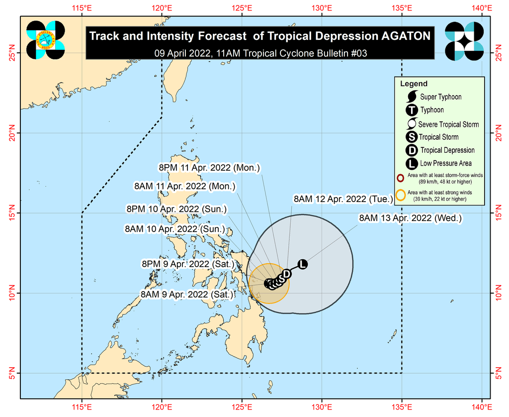
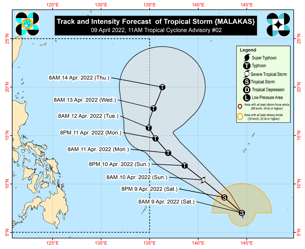
Agaton could begin turning northeast on Monday afternoon or on Tuesday, April 12, as it interacts with the incoming Tropical Storm Malakas, which is currently still outside the Philippine Area of Responsibility (PAR).
Malakas was last spotted 1,965 kilometers east of Mindanao late Saturday morning. It may enter PAR either late Monday or early Tuesday, and would be given the local name Basyang.
So far, Malakas still has maximum sustained winds of 75 km/h and gustiness of up to 90 km/h. But it is expected to reach typhoon status late Sunday, April 10, or early Monday, then reach a peak intensity of 155 km/h late Monday or early Tuesday.
Malakas or Basyang is not expected to make landfall in the Philippines and is also unlikely to directly affect weather in the country, PAGASA said.
But Malakas is projected to influence Agaton’s movement once it enters PAR. As a result, Agaton could weaken and eventually become a remnant low by late Tuesday or early Wednesday, April 13, as it gets absorbed by Malakas.
PAGASA Senior Weather Specialist Chris Perez also announced that a low pressure area formed over the West Philippine Sea, located 565 kilometers west southwest of Puerto Princesa City, Palawan, early Saturday morning. The weather bureau is expected to give updates on this LPA as well.
Meanwhile, sea travel remains risky on Saturday.
Rough to very rough seas due to Agaton
Waves 2.8 to 4.5 meters high; conditions risky for most vessels
- seaboards of areas under Signal No. 1
- northern and eastern coastal waters of Northern Samar
Rough to very rough seas due to the northeasterly surface windflow
Waves 2.8 to 4.5 meters high; small vessels advised not to sail, larger vessels alerted against big waves
- northern and western seaboards of Northern Luzon (Batanes, Babuyan Islands, northern coast of Cagayan, Ilocos Norte)
Moderate to rough seas
Waves 1.2 to 3.4 meters high; conditions risky for small vessels
- remaining seaboards of the Philippines
The northeasterly surface windflow is also causing rain in Northern Luzon on Saturday, particularly in these provinces:
- Batanes
- Cagayan
- Isabela
- Apayao
- Kalinga
- Abra
- Ilocos Norte
The other parts of Luzon which are not affected by either Agaton or the northeasterly surface windflow only have isolated rain showers or thunderstorms. – Rappler.com
Add a comment
How does this make you feel?


There are no comments yet. Add your comment to start the conversation.