SUMMARY
This is AI generated summarization, which may have errors. For context, always refer to the full article.
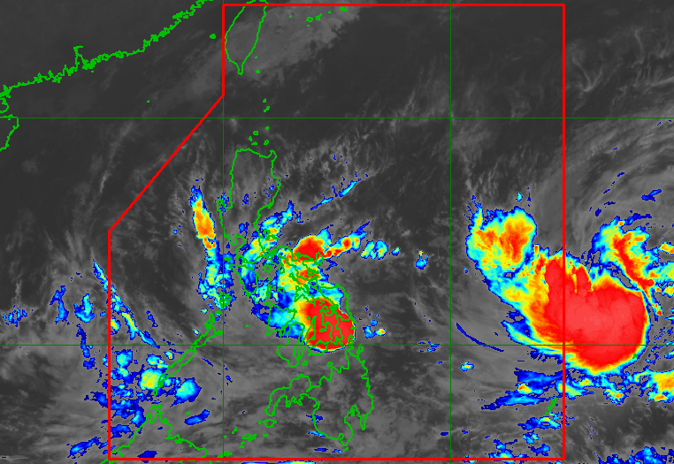
MANILA, Philippines – Tropical Storm Agaton (Megi) weakened a bit ahead of its second landfall in the Philippines late Sunday evening, April 10, though it continued to bring intense rain to some areas in the Visayas and Luzon.
The Philippine Atmospheric, Geophysical, and Astronomical Services Administration (PAGASA) said Agaton was over the coastal waters of Mayorga, Leyte, slowly moving west and set to make landfall in the eastern part of the province.
Agaton earlier made landfall in Calicoan Island in Guiuan, Eastern Samar, at 7:30 am on Sunday.
The tropical storm’s maximum sustained winds decreased from 75 kilometers per hour to 65 km/h late Sunday evening, while its gustiness went down from 105 km/h to 90 km/h.
Despite the slight weakening, Agaton still poses a threat. Below is PAGASA’s rainfall forecast as of 11 pm on Sunday.
Sunday evening, April 10, until Monday evening, April 11
Moderate to heavy rain, with at times intense rain
- Eastern Visayas
- northern and central parts of Cebu including Bantayan and Camotes Islands
- Masbate
- Sorsogon
- Catanduanes
Light to moderate rain, with at times heavy rain
- Dinagat Islands
- rest of Visayas
- rest of Bicol
- Oriental Mindoro
- Marinduque
- Romblon
Monday evening, April 11, until Tuesday evening, April 12
Moderate to heavy rain, with at times intense rain
- Sorsogon
- Masbate
- Eastern Visayas
Light to moderate rain, with at times heavy rain
- Dinagat Islands
- rest of Visayas
- Romblon

Here are the areas under tropical cyclone wind signals as of 11 pm:
Signal No. 2
Gale-force winds; minor to moderate threat to life and property
- southern part of Eastern Samar (Balangkayan, Llorente, General MacArthur, Hernani, Quinapondan, Giporlos, Salcedo, Balangiga, Lawaan)
- southern part of Samar (Daram, Zumarraga, Villareal, Talalora, Santa Rita, Pinabacdao, Basey, Marabut)
- Biliran
- northern and central parts of Leyte (Calubian, Leyte, Capoocan, Barugo, San Miguel, Babatngon, Tacloban City, Santa Fe, Palo, Tanauan, Tolosa, Dulag, Mayorga, MacArthur, Abuyog, Javier, Albuera, Kananga, Ormoc City, Villaba, Tabango, San Isidro, Matag-ob, Jaro, Carigara, Tunga, Alangalang, Pastrana, Dagami, Tabontabon, Julita, Burauen, La Paz)
- northern part of Dinagat Islands (Loreto, Tubajon)
Signal No. 1
Strong winds; minimal to minor threat to life and property
- southern part of Masbate (Dimasalang, Palanas, Cataingan, Pio V. Corpuz, Esperanza, Placer, Cawayan)
- rest of Eastern Samar
- rest of Samar
- Northern Samar
- rest of Leyte
- Southern Leyte
- northeastern part of Cebu (Daanbantayan, Medellin, Bantayan Islands, Bogo City, San Remigio, Tabogon, Borbon, Tabuelan, Sogod, Catmon, Carmen, Danao City, Compostela, Liloan, Tuburan, Asturias) including Camotes Island
- eastern part of Bohol (Buenavista, Danao, Dagohoy, Pilar, Guindulman, Candijay, Mabini, Alicia, Ubay, San Miguel, President Carlos P. Garcia, Trinidad, Bien Unido, Talibon, Jetafe)
- Surigao del Norte
- rest of Dinagat Islands

Until early Tuesday, April 12, Agaton is expected to linger in the vicinity of the northern part of Leyte, the southern part of Samar, and Biliran, as well as the coastal waters of these areas. “The frictional effects of land on its circulation” could cause Agaton to weaken into a tropical depression, PAGASA said.
Agaton could turn east southeast or east by Tuesday afternoon or evening as it interacts with the incoming Severe Tropical Storm Malakas, which may enter the Philippine Area of Responsibility (PAR) by Monday evening, April 11, or Tuesday morning. Malakas would be given the local name Basyang.
When Malakas or Basyang starts to merge with or absorb Agaton, the latter may further weaken into a remnant low by late Wednesday, April 13, or early Thursday, April 14. But PAGASA said Agaton could also be downgraded to a low pressure area earlier than that, while it is over the Leyte-Samar landmass.
As of late Sunday evening, Malakas was already 1,315 kilometers east of the Visayas. The severe tropical storm slowed down, however, moving west northwest at only 15 km/h from the previous 35 km/h.
Malakas maintained its strength, with maximum sustained winds of 95 km/h and gustiness of up to 115 km/h. But it is likely to intensify into a typhoon by Monday evening, around the same time of its entry into PAR, then reach a peak intensity of 155 km/h late Tuesday or early Wednesday.
Malakas or Basyang is not seen to make landfall and will have no direct effect on weather in the Philippines. It is expected to leave PAR late Tuesday or early Wednesday.

PAGASA also warned that sea travel remains risky on Monday.
Rough to very rough seas
Waves 2.8 to 4.5 meters high; conditions risky for most vessels
- seaboards of areas under Signal Nos. 1 and 2
Moderate to rough seas
Waves 1.2 to 3.4 meters high; conditions risky for small vessels
- remaining seaboards of the Philippines
Meanwhile, the low pressure area (LPA) inside PAR was located 215 kilometers southwest of Puerto Princesa City, Palawan, late Sunday evening.
The LPA only has a slim chance of developing into a tropical depression, but it is affecting Palawan. – Rappler.com
Add a comment
How does this make you feel?


There are no comments yet. Add your comment to start the conversation.