SUMMARY
This is AI generated summarization, which may have errors. For context, always refer to the full article.
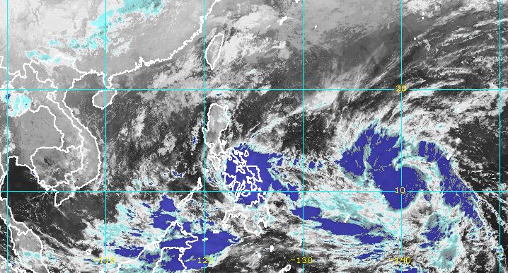
MANILA, Philippines – Agaton intensified from a tropical depression into a tropical storm before dawn on Sunday, April 10, as it moved over the coastal waters of Guiuan, Eastern Samar.
Agaton’s maximum sustained winds increased from 55 kilometers per hour to 65 km/h, while its gustiness is already up to 80 km/h from the previous 70 km/h.
It finally started to move west northwest at 10 km/h after being almost stationary for several hours.
The Philippine Atmospheric, Geophysical, and Astronomical Services Administration (PAGASA) sees Agaton either slowly moving west northwest or being almost stationary until late Monday, April 11, or early Tuesday, April 12.
But PAGASA noted that “considering its erratic movement, there is an increasing likelihood of landfall over the southern portion of Eastern Samar in the next several hours.”
With Agaton now a tropical storm, PAGASA raised Signal No. 2 for the first time. Below are the areas under tropical cyclone wind signals as of 5 am on Sunday.
Signal No. 2
Gale-force winds; minor to moderate threat to life and property
- southern part of Eastern Samar (Guiuan, Mercedes, Salcedo, Quinapondan, Giporlos, Balangiga, Lawaan, General MacArthur, Hernani, Llorente)
- extreme southern part of Samar (Marabut)
- northern part of Dinagat Islands (Loreto, Tubajon)
Signal No. 1
Strong winds; minimal to minor threat to life and property
- rest of Eastern Samar
- rest of Samar
- Northern Samar
- Biliran
- Leyte
- Southern Leyte
- Camotes Islands
- Surigao del Norte
- rest of Dinagat Islands
PAGASA stressed that Agaton could cause scattered to widespread floods and landslides as it will dump more rain on Sunday and Monday.
Sunday, April 10
Heavy to intense rain, with at times torrential rain
- Eastern Visayas
- Dinagat Islands
Moderate to heavy rain, with at times intense rain
- Surigao del Norte
- Agusan del Norte
- Bohol
- northern and central parts of Cebu including Bantayan and Camotes Islands
Light to moderate rain, with at times heavy rain
- Masbate
- Sorsogon
- rest of Caraga
- Northern Mindanao
- rest of Visayas
Monday, April 11
Moderate to heavy rain, with at times intense rain
- Eastern Visayas
- northern part of Cebu including Bantayan and Camotes Islands
- Dinagat Islands
- Surigao del Norte
Light to moderate rain, with at times heavy rain
- Masbate
- Sorsogon
- rest of Visayas
- rest of Caraga

PAGASA said Agaton is likely to remain a tropical storm, but the possibility of it getting downgraded back into a tropical depression is not being ruled out due to its potential landfall in Eastern Samar.
Agaton may start turning east by mid-Tuesday as it interacts with the incoming Tropical Storm Malakas, which remains outside the Philippine Area of Responsibility (PAR).
Malakas was last spotted 1,790 kilometers east of Mindanao before dawn on Sunday, moving northwest at 25 km/h. It could enter PAR on Tuesday and would be given the local name Basyang.
Malakas also slightly intensified, with its maximum sustained winds increasing from 75 km/h to 85 km/h. Its gustiness is now up to 105 km/h from the previous 90 km/h.
It is expected to strengthen into a severe tropical storm on Sunday, and then into a typhoon on Sunday evening or Monday morning. It could reach a peak intensity of 155 km/h on Tuesday.
Malakas or Basyang is not expected to directly affect the weather in the Philippines, but it will influence Agaton’s movement. As Malakas interacts with Agaton, the latter is projected to weaken into a remnant low and get absorbed by Malakas late Tuesday or early Wednesday, April 13.
PAGASA also reminded the public that sea travel is still risky.
Rough to very rough seas
Waves 2.8 to 5 meters high; conditions risky for most vessels
- seaboards of areas under Signal Nos. 1 and 2
Moderate to rough seas
Waves 1.2 to 3.4 meters high; conditions risky for small vessels
- remaining seaboards of the Philippines
Meanwhile, the low pressure area (LPA) over the West Philippine Sea that PAGASA has been monitoring already entered PAR at 2 am on Sunday.
The LPA was last spotted 415 kilometers west southwest of Puerto Princesa City, Palawan.
PAGASA Weather Specialist Benison Estareja said the LPA only has a slim chance of developing into a tropical depression, but it is bringing rain to Palawan. – Rappler.com
Add a comment
How does this make you feel?


There are no comments yet. Add your comment to start the conversation.