SUMMARY
This is AI generated summarization, which may have errors. For context, always refer to the full article.
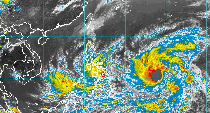
MANILA, Philippines – More areas were placed under tropical cyclone wind signals late Sunday afternoon, April 10, due to Tropical Storm Agaton (Megi), which continues to move slowly off Eastern Visayas.
Agaton was last spotted over the coastal waters of Lawaan, Eastern Samar, inching westward, the Philippine Atmospheric, Geophysical, and Astronomical Services Administration (PAGASA) said in its 5 pm bulletin.
The tropical storm continues to have maximum sustained winds of 75 kilometers per hour and gustiness of up to 105 km/h.
Agaton earlier made landfall in Calicoan Island in Guiuan, Eastern Samar, at 7:30 am on Sunday.
Here are the areas covered by tropical cyclone wind signals as of 5 pm on Sunday:
Signal No. 2
Gale-force winds; minor to moderate threat to life and property
- central and southern parts of Eastern Samar (Dolores, Maslog, Can-avid, Taft, Sulat, San Julian, Borongan City, Maydolong, Balangkayan, Llorente, General MacArthur, Hernani, Balangiga, Lawaan, Quinapondan, Giporlos, Salcedo, Mercedes, Guiuan)
- central and southern parts of Samar (San Jose de Buan, San Jorge, Tarangnan, Catbalogan City, Jiabong, Motiong, Paranas, Hinabangan, Calbiga, Pinabacdao, Villareal, Daram, Zumarraga, Talalora, Santa Rita, Basey, Marabut, San Sebastian)
- Biliran
- northern and eastern parts of Leyte (Leyte, Capoocan, Carigara, Barugo, San Miguel, Babatngon, Tacloban City, Alangalang, Tunga, Jaro, Kananga, Ormoc City, Santa Fe, Palo, Pastrana, Dagami, Tanauan, Tabontabon, Tolosa, Dulag, Mayorga, MacArthur, Abuyog, Mahaplag, Javier, La Paz, Julita, Burauen)
- northern part of Dinagat Islands (Loreto, Tubajon)
Signal No. 1
Strong winds; minimal to minor threat to life and property
- southern part of Masbate (Dimasalang, Palanas, Cataingan, Pio V. Corpuz, Esperanza, Placer, Cawayan)
- rest of Eastern Samar
- rest of Samar
- Northern Samar
- rest of Leyte
- Southern Leyte
- northeastern part of Cebu (Daanbantayan, Medellin, Bantayan Islands, Bogo City, San Remigio, Tabogon, Borbon, Tabuelan, Sogod, Catmon, Carmen, Danao City, Compostela, Liloan) including Camotes Island
- eastern part of Bohol (Buenavista, Danao, Dagohoy, Pilar, Guindulman, Candijay, Mabini, Alicia, Ubay, San Miguel, President Carlos P. Garcia, Trinidad, Bien Unido, Talibon, Jetafe)
- Surigao del Norte
- rest of Dinagat Islands
Aside from strong winds, the rain brought by Agaton could trigger more floods and landslides. PAGASA stressed the need to stay alert, with the tropical storm barely moving.
Sunday, April 10
Moderate to heavy rain, with at times intense rain
- Masbate
- Sorsogon
- Eastern Visayas
- Cebu
- Bohol
- Dinagat Islands
Light to moderate rain, with at times heavy rain
- Albay
- Catanduanes
- Romblon
- rest of Visayas
- Surigao del Norte
- Agusan del Norte
- Northern Mindanao
Monday, April 11
Moderate to heavy rain, with at times intense rain
- Sorsogon
- Masbate
- Eastern Visayas
- northern part of Negros Occidental
- northern part of Negros Oriental
- northeastern part of Iloilo
- northeastern part of Capiz
- Cebu
- Bohol
Light to moderate rain, with at times heavy rain
- Romblon
- rest of Visayas

PAGASA expects Agaton to move erratically or remain almost stationary in the eastern part of Leyte as well as in the southern part of Samar Island and its coastal waters until early Tuesday, April 12.
Then the tropical storm could turn east southeast or east by Tuesday afternoon or evening as it interacts with another tropical cyclone, the incoming Malakas.
Malakas, which remains outside the Philippine Area of Responsibility (PAR), intensified from a tropical storm into a severe tropical storm on Sunday afternoon. Its maximum sustained winds increased from 85 km/h to 95 km/h, while its gustiness is now up to 115 km/h from the previous 105 km/h.
The severe tropical storm was last spotted 1,425 kilometers east of Mindanao. It slightly accelerated again, moving northwest at a fast 35 km/h.
At that rate, Malakas may enter PAR late Monday, April 11, or early Tuesday, and would be given the local name Basyang. Before it enters PAR, it is likely to strengthen into a typhoon.
Malakas or Basyang is not seen to make landfall and will have no direct effect on weather in the Philippines, but it will influence Agaton’s movement. As Malakas interacts with Agaton, the latter is projected to weaken into a remnant low and get absorbed by Malakas late Wednesday, April 13, or early Thursday, April 14.
PAGASA also warned that sea travel will remain dangerous on Sunday evening until Monday.
Rough to very rough seas
Waves 2.8 to 5 meters high; conditions risky for most vessels
- seaboards of areas under Signal Nos. 1 and 2
Moderate to rough seas
Waves 1.2 to 3.4 meters high; conditions risky for small vessels
- remaining seaboards of the Philippines
Meanwhile, the low pressure area (LPA) inside PAR was located 185 kilometers southwest of Puerto Princesa City, Palawan, late Sunday afternoon.
PAGASA earlier said the LPA only has a slim chance of developing into a tropical depression. – Rappler.com
Add a comment
How does this make you feel?


There are no comments yet. Add your comment to start the conversation.