SUMMARY
This is AI generated summarization, which may have errors. For context, always refer to the full article.
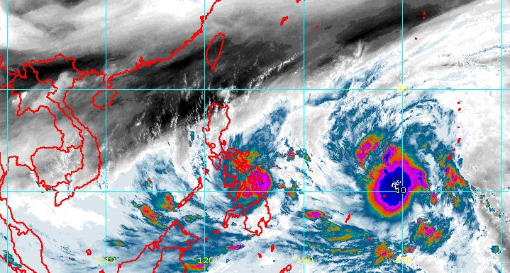
MANILA, Philippines – Tropical Storm Agaton intensified further early Sunday morning, April 10, as it was about to make landfall over the southeastern part of Eastern Samar.
The Philippine Atmospheric, Geophysical, and Astronomical Services Administration (PAGASA) said in a bulletin released shortly before 9 am that Agaton already has maximum sustained winds of 75 kilometers per hour and gustiness of up to 105 km/h.
The tropical storm previously had maximum sustained winds of 65 km/h and gustiness of up to 80 km/h.
Agaton was still located over the coastal waters of Guiuan, Eastern Samar, continuing to move west northwest at 10 km/h. After it hits land, there is a possibility that it may be downgraded back to a tropical depression.
PAGASA reiterated that scattered to widespread floods and landslides could occur. Below is the weather bureau’s rainfall forecast for the tropical storm as of 8 am on Sunday.
Sunday, April 10
Heavy to intense rain, with at times torrential rain
- Eastern Visayas
- Dinagat Islands
Moderate to heavy rain, with at times intense rain
- Surigao del Norte
- Agusan del Norte
- Bohol
- Cebu
Light to moderate rain, with at times heavy rain
- Masbate
- Sorsogon
- Albay
- Catanduanes
- Romblon
- rest of Caraga
- Northern Mindanao
- rest of Visayas
Monday, April 11
Moderate to heavy rain, with at times intense rain
- Eastern Visayas
- northern part of Cebu including Bantayan and Camotes Islands
- Dinagat Islands
- Surigao del Norte
Light to moderate rain, with at times heavy rain
- Masbate
- Sorsogon
- rest of Visayas
- rest of Caraga
More areas were placed under tropical cyclone wind signals as of 8 am on Sunday.
Signal No. 2
Gale-force winds; minor to moderate threat to life and property
- southern part of Eastern Samar (Guiuan, Mercedes, Salcedo, Quinapondan, Giporlos, Balangiga, Lawaan, General MacArthur, Hernani, Llorente, Balangkayan, Maydolong, Borongan City)
- southern part of Samar (Marabut, Basey, Calbiga, Pinabacdao, Villareal, Santa Rita)
- northeastern part of Leyte (Babatngon, Tacloban City, Palo, Tanauan, Tolosa)
- northern part of Dinagat Islands (Loreto, Tubajon)
Signal No. 1
Strong winds; minimal to minor threat to life and property
- rest of Eastern Samar
- rest of Samar
- Northern Samar
- Biliran
- rest of Leyte
- Southern Leyte
- northeastern part of Cebu (Daanbantayan, Medellin, Bogo City, Tabogon, Borbon) including Camotes Islands
- Surigao del Norte
- rest of Dinagat Islands
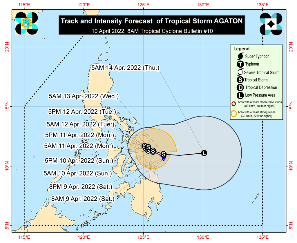
PAGASA said Agaton is expected to move erratically or stay almost stationary over the southern part of Samar Island and its coastal waters until early Tuesday, April 12.
Then the tropical storm could turn east southeast or east by mid-Tuesday as it interacts with the incoming Tropical Storm Malakas, which remains outside the Philippine Area of Responsibility (PAR).
PAGASA said earlier on Sunday that Malakas was located 1,790 kilometers east of Mindanao, moving northwest at 25 km/h. It could enter PAR on Tuesday and would be given the local name Basyang.
Malakas’ maximum sustained winds were at 85 km/h, with gustiness of up to 105 km/h, before dawn on Sunday. It is expected to strengthen into a severe tropical storm on Sunday, and then into a typhoon on Sunday evening or Monday morning, April 11.
Malakas or Basyang is not expected to directly affect the weather in the Philippines, but it will influence Agaton’s movement. As Malakas interacts with Agaton, the latter is projected to weaken into a remnant low and get absorbed by Malakas late Tuesday or early Wednesday, April 13.
Sea travel remains risky on Sunday.
Rough to very rough seas
Waves 2.8 to 5 meters high; conditions risky for most vessels
- seaboards of areas under Signal Nos. 1 and 2
Moderate to rough seas
Waves 1.2 to 3.4 meters high; conditions risky for small vessels
- remaining seaboards of the Philippines
At 5 am on Sunday, the Philippine Coast Guard Station Sorsogon suspended all trips of vessels going to Eastern Samar, Samar, Northern Samar, Biliran, Leyte, Southern Leyte, and Camotes Islands. – Rappler.com
Add a comment
How does this make you feel?


There are no comments yet. Add your comment to start the conversation.