SUMMARY
This is AI generated summarization, which may have errors. For context, always refer to the full article.
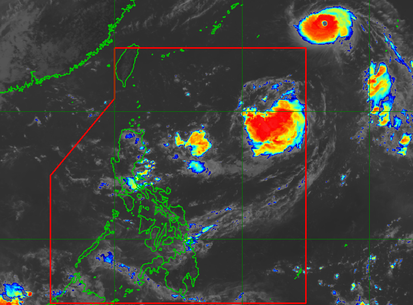
MANILA, Philippines – Forecasters are monitoring a typhoon outside the Philippine Area of Responsibility and a low pressure area (LPA) that formed inside PAR.
The typhoon, which has the international name Hinnamnor, was located 1,655 kilometers east northeast of extreme Northern Luzon on Tuesday morning, August 30, according to an advisory from the Philippine Atmospheric, Geophysical, and Astronomical Services Administration (PAGASA).
Hinnamnor is moving west at a relatively fast 30 kilometers per hour (km/h) and could enter PAR on Wednesday evening, August 31.
PAGASA sees Hinnamnor slowing down, however, starting Wednesday. It may even become almost stationary on Friday, September 2, until Saturday, September 3.
As of Tuesday morning, Hinnamnor had maximum sustained winds of 165 km/h and gustiness of up to 205 km/h.
“This typhoon may continue to rapidly intensify over the sea south of Japan and reach super typhoon category within 24 hours,” PAGASA said.
This means Hinnamnor may enter PAR as a super typhoon, defined by PAGASA as a tropical cyclone with maximum sustained winds of 185 km/h or above.
Based on its latest forecast track, Hinnamnor is not expected to make landfall in the Philippines, as it will only stay near the PAR northern boundary.
But PAGASA warned that Hinnamnor’s winds “may continue to expand in the coming days as it moves towards the northern Philippine Sea.” Tropical cyclone wind signals could be raised for extreme Northern Luzon even if Hinnamnor does not hit land.
The typhoon might also cause rough seas in the northern and eastern seaboards of Luzon beginning late Thursday, September 1, or early Friday. Conditions would be risky for small vessels.
Hinnamnor may eventually leave PAR by early Sunday, September 4.

Meanwhile, the LPA was located 1,235 kilometers east of extreme Northern Luzon on Tuesday morning.
PAGASA said the LPA could develop into a tropical depression within 24 hours.
Its trough or extension will trigger scattered rain and thunderstorms in the provinces of Aurora and Camarines Norte, and in the region of Calabarzon.
Once Hinnamnor enters PAR and the LPA becomes a tropical depression, they would be given the local names Gardo and Henry.
PAGASA Weather Specialist Aldczar Aurelio said earlier on Tuesday that the two weather systems could merge, with the bigger Hinnamnor absorbing the smaller circulation.
PAGASA expects 7 to 11 tropical cyclones to enter or develop inside PAR from September 2022 to February 2023. Per month, these are the weather bureau’s estimates:
- September 2022 – 2 or 3
- October 2022 – 2 to 4
- November 2022 – 2 or 3
- December 2022 – 1 or 2
- January 2023 – 0 or 1
- February 2023 – 0 or 1
– Rappler.com
Add a comment
How does this make you feel?
There are no comments yet. Add your comment to start the conversation.