SUMMARY
This is AI generated summarization, which may have errors. For context, always refer to the full article.
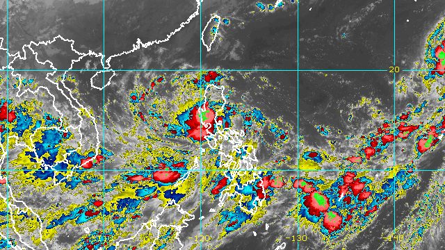
MANILA, Philippines – After hitting Quezon and Aurora, Typhoon Karding (Noru) was crossing Nueva Ecija late Sunday evening, September 25.
Karding, previously a super typhoon, was downgraded to a typhoon after its first landfall in Burdeos, Quezon, at 5:30 pm. By the time it made its second landfall in Dingalan, Aurora, at 8:20 pm, it had already been downgraded.
Though it has weakened a bit, Karding remains a powerful tropical cyclone and still poses a threat to much of Luzon.
The typhoon was last spotted in the vicinity of San Leonardo, Nueva Ecija, moving west northwest at 20 kilometers per hour (km/h).
In its 11 pm bulletin on Sunday, the Philippine Atmospheric, Geophysical, and Astronomical Services Administration (PAGASA) said Karding will continue to cross Central Luzon in the coming hours, before emerging over the West Philippine Sea via the coastal waters of Zambales or Pangasinan early Monday morning, September 26.
Its maximum sustained winds have gone down to 175 km/h, with gustiness of up to 215 km/h. At its peak, Karding had maximum sustained winds of 195 km/h.
PAGASA expects Karding to remain a typhoon even as it weakens while crossing landmass. It may re-intensify once it is over the West Philippine Sea.
There are no more areas under Signal No. 5 since Karding has been downgraded to a typhoon. But Signal Nos. 1 to 4 remain in effect.
Signal No. 4
Typhoon-force winds (118 to 184 km/h), significant to severe threat to life and property
- central and southern parts of Nueva Ecija (Llanera, Cuyapo, Talugtug, Science City of Muñoz, Rizal, Bongabon, Laur, Gabaldon, Nampicuan, Guimba, Santo Domingo, Talavera, General Mamerto Natividad, Palayan City, General Tinio, Gapan City, Peñaranda, Santa Rosa, Cabanatuan City, Aliaga, Quezon, Licab, Zaragoza, Jaen, San Leonardo, San Isidro, San Antonio, Cabiao)
- Tarlac
- Pampanga
- Bulacan
- northern and central parts of Zambales (Santa Cruz, Candelaria, Masinloc, Palauig, Iba, Botolan, Cabangan, San Felipe, San Marcelino, San Narciso)
- southern part of Pangasinan (Bautista, Alcala, Bayambang, Mangatarem, Urbiztondo, Aguilar, Bugallon, Infanta, Dasol, Burgos, Mabini, Labrador)
Signal No. 3
Storm-force winds (89 to 117 km/h), moderate to significant threat to life and property
- southern and central parts of Aurora (Baler, Maria Aurora, San Luis, Dingalan)
- rest of Nueva Ecija
- Bataan
- rest of Zambales
- rest of Pangasinan
- northern part of Rizal (Rodriguez, San Mateo, Cainta, Antipolo City, Taytay, Angono, Teresa, Tanay, Baras, Morong)
- Metro Manila
- extreme northern part of Quezon (General Nakar)
Signal No. 2
Gale-force winds (62 to 88 km/h), minor to moderate threat to life and property
- rest of Aurora
- Nueva Vizcaya
- Quirino
- Benguet
- La Union
- Cavite
- Batangas
- Laguna
- rest of Rizal
- northern and central parts of Quezon (Real, Infanta, Mauban, San Antonio, Tiaong, Dolores, Candelaria, Sariaya, Lucena City, Tayabas City, Lucban, Sampaloc, Mauban, Atimonan, Pagbilao, Guinayangan, Tagkawayan, Calauag, Perez, Alabat, Quezon, Padre Burgos, Agdangan, Unisan, Plaridel, Gumaca, Lopez, Pitogo, Macalelon, General Luna, Buenavista, Catanauan) including Polillo Islands
- western part of Camarines Norte (Santa Elena, Capalonga, Jose Panganiban, Labo, Paracale, Vinzons) including Calaguas Islands
Signal No. 1
Strong winds (39 to 61 km/h), minimal to minor threat to life and property
- Isabela
- Mountain Province
- Ifugao
- Kalinga
- Abra
- Ilocos Sur
- rest of Quezon
- northern part of Occidental Mindoro (Paluan, Abra de Ilog, Mamburao, Santa Cruz) including Lubang Islands
- northern part of Oriental Mindoro (Puerto Galera, San Teodoro, Baco, Calapan City, Naujan, Victoria, Pola, Socorro, Pinamalayan)
- Marinduque
- rest of Camarines Norte
- Camarines Sur
- Burias Island
Karding also continues to trigger rain which may cause widespread floods and landslides. The weather bureau updated its rainfall forecast for the typhoon as of 11 pm on Sunday.
Until Monday morning
Heavy to intense rain, with at times torrential rain
- northern part of Metro Manila
- Central Luzon
- Laguna
- Rizal
- northern part of Quezon including Polillo Islands
Moderate to heavy rain, with at times intense rain
- southern part of Metro Manila
- Isabela
- Nueva Vizcaya
- Quirino
- Kalinga
- Mountain Province
- Ifugao
- Benguet
- Cavite
- Batangas
- Laguna
- central part of Quezon
- northern part of Occidental Mindoro
- northern part of Oriental Mindoro
Light to moderate rain, with at times heavy rain
- mainland Cagayan
- rest of Cordillera Administrative Region
- rest of Quezon
- rest of Occidental Mindoro
- rest of Oriental Mindoro
Monday morning to afternoon
Moderate to heavy rain, with at times intense rain
- Zambales
- Bataan
- northern part of Occidental Mindoro
- northern part of Oriental Mindoro
Light to moderate rain, with at times heavy rain
- Metro Manila
- Cavite
- Batangas
- Rizal
- rest of Occidental Mindoro
- rest of Oriental Mindoro
Aside from Karding, the southwest monsoon or hanging habagat is bringing rain as well.
In a separate advisory at 11 pm on Sunday, PAGASA warned that the southwest monsoon is causing moderate to heavy rain in Western Visayas, Negros Oriental, and Palawan. Light to moderate rain, with at times heavy rain, will also hit the rest of Central Visayas, the Zamboanga Peninsula, and Misamis Occidental.
Scattered floods and landslides are possible in areas affected by the southwest monsoon.

There is still a moderate to high risk of storm surges in the following areas due to Karding:
- Pangasinan
- Zambales
- Bulacan
- northern part of Metro Manila
- southern part of La Union
- Aurora
- northern part of Quezon
PAGASA warned that the combined effects of storm surges and high waves breaking along the coast may cause “life-threatening and damaging” floods.
A gale warning remains in place for the following seaboards:
Very rough to phenomenal seas
Waves 10.3 to 14.1 meters high
- eastern seaboard of Central Luzon and Southern Luzon (Aurora, eastern coast of Quezon including Polillo, Camarines Norte, Camarines Sur, Catanduanes)
Rough to very rough seas
Waves 2.8 to 4.5 meters high
- eastern and western seaboards of Northern Luzon (Cagayan, La Union, Pangasinan, Isabela)
- western seaboard of Central Luzon and Southern Luzon, as well as southern seaboard of Southern Luzon (Zambales, Bataan, Metro Manila, Cavite, Batangas, Romblon, Marinduque, Oriental Mindoro, Occidental Mindoro, southwestern coast of Camarines Sur, southern coast of Quezon)
Such conditions are risky for all vessels.
Karding is projected to leave the Philippine Area of Responsibility (PAR) on Monday evening.

Karding is the Philippines’ 11th tropical cyclone for 2022.
It is also the third tropical cyclone for September, after Typhoon Inday (Muifa) and Super Typhoon Josie (Nanmadol). Inday and Josie did not make landfall in the country.
PAGASA expects 7 to 11 tropical cyclones to enter or develop inside PAR from September 2022 to February 2023. Per month, these are the weather bureau’s estimates:
- September 2022 – 2 or 3
- October 2022 – 2 to 4
- November 2022 – 2 or 3
- December 2022 – 1 or 2
- January 2023 – 0 or 1
- February 2023 – 0 or 1
– Rappler.com
Add a comment
How does this make you feel?


There are no comments yet. Add your comment to start the conversation.