SUMMARY
This is AI generated summarization, which may have errors. For context, always refer to the full article.
The warning came through to the Quarry Road community on the banks of the Palmiet River via a group chat platform late that Monday night: “Don’t go to sleep. The river is rising. There’s more rain on the way. Be ready to evacuate.”
Families living along this stretch of one of the 18 major rivers of Durban, South Africa, believe it was this warning that spared them any drownings when floodwaters tore apart many of their makeshift board-and-tin homes.
But on April 11, 2022, a worst-case scenario was nevertheless unfolding.
Community leader Nomandla Nqanula had eyes on a nearby bridge. She snapped a photo and fired it off to the city’s disaster management team, showing that tree debris and other flotsam were snarled up against the structure, trapping the water’s escape. A short while later, the final instruction came through from the disaster unit. It was time to get to higher ground.
It was like a disaster movie, Nqanula says, with containers from nearby shops caught in the current and slamming into dwellings. Then there was the final terrifying escape as she and her neighbors formed a human chain to cross a nearby highway that was disappearing under the fast-flowing water.
When the sun rose on Tuesday, there was nothing but a hole gouged into the bank where Nqanula’s home had stood. Like many, everything she owned had been washed away. Their lives, at least, had been spared.
Other communities in the eThekwini municipality on South Africa’s east coast, more commonly known as the city of Durban, weren’t so lucky.
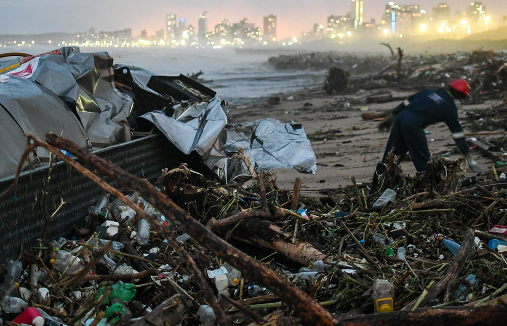
By the time President Cyril Ramaphosa called a state of emergency on April 19, at least 435 people had died and 54 were missing. Thousands had lost their homes and businesses. Roads and bridges were torn away, communications knocked out, sewerage works gutted, and water infrastructure and power grids destroyed.
Initial damages costs were estimated at R17 billion (over US$910,000), although the final bill might run even higher than R25 billion (over US$1.3 million), eThekwini’s senior manager in the climate protection branch, Dr. Sean O’Donoghue, said in a webinar a month after the disaster.
It was the perfect storm: referring not just to the weather system, but also to the physical shape of the city it hit.
Durban is a complicated sprawl of old settlements and new; concrete and steel standing alongside shantytowns; where infrastructure and service delivery are steps behind the needs of its fast-growing population; where hilly terrain is shot through with boom-and-bust rivers.
No coastal city – no matter how developed – will escape the extreme events coming with global heating. While the “global south” cities are uniquely vulnerable, insights from the storms that brought severe inland river flooding to Durban in April 2022 show how they can brace for future impacts.
Real-time data meets community members where they are
Resilience is the ability to bounce back after a shock like this, be it a community, a person, or a system.
That night at Quarry Road, the city was piloting a novel approach to its existing early-warning system that, if it worked, could help other flood-exposed communities not only survive these inevitable and escalating events but also to have a better recovery.
The first red flag arrived months before the April storm.
The South African Weather Service warned that the ongoing La Niña weather cycle – a years-long natural event that brings higher-than-average rainfall to South Africa – had waterlogged the soils ahead of the 2022 rainy season. The saturated ground wouldn’t be able to hold much more water, increasing the likelihood of floods.
Then, on April 10, the Weather Service issued a level 9 weather warning on its 1–10 alert system. It had issued a level 10 warning only once before, in January 2021, when tropical storm Eloise landed on South Africa’s coast, affecting neighboring countries and hitting Mozambique particularly hard.
The short-range forecast that April predicted a cut-off low that would bring a high chance of dangerous flooding. It kicked eThekwini’s Disaster Management and Emergency Control Unit’s protocols into play.
In Quarry Road, the community-based early-warning system that was in the making for eight years was now being tested in real time. This meant marrying the city-wide forecast with the finer details of the catchment that feeds into the Palmiet River.
Information began flying across a digital group chat platform that allowed the various parties – the city’s disaster management unit, its senior climate scientist, a university academic who helped design the system, and volunteers within the community – to stay in touch.
The city’s catchment manager began monitoring the rain gauge upriver of Quarry Road, knowing from hydrology models that it would take 40 minutes for the water to travel from there to the Quarry Road community. The water had already risen to a dangerous two metres and more was on the way.
When Nqanula reported the bridge blockage, the disaster team escalated the response. Time to evacuate.
It was 11 pm. She had just enough time to grab her identity document and cell phone.
The system is novel in a few ways, says University of KwaZulu Natal’s School of Built Environment and Development Studies geographer Catherine Sutherland, who is part of its design and piloting.
Rather than relying only on a blunt catchment-wide weather forecast, the system zooms in on local-scale conditions and real-time data. It uses the SA Weather Service’s new impact-based weather alert system, which goes beyond simply giving details of how much rain might fall or what wind speeds to expect, but flags the likely damage these might cause to the built environment, explains chief forecaster Kevin Rae.
It then relies on individuals in the affected community to draw the most complete picture of the event as it unfolds.
This kind of early-warning system is just one lever in the complicated machinery of a city system in an emergency situation like this, and a good example of how it can build better resilience.
Climate issues wrapped in systemic problems
Durban’s 2022 storm was extreme but not unprecedented. Parts of the city were uniquely exposed because of the features of its built environment and the human systems that run it. The natural landscape on which these are built played a role, as did the social and economic context in which people live, and the people themselves.
Durban is the country’s third-largest city, with a population of 3.9 million and climbing as more people are drawn from the countryside in search of a better life. The city has many well-established suburbs, but it also has a housing backlog of 387,000 units for those who can’t get into the formal property market.
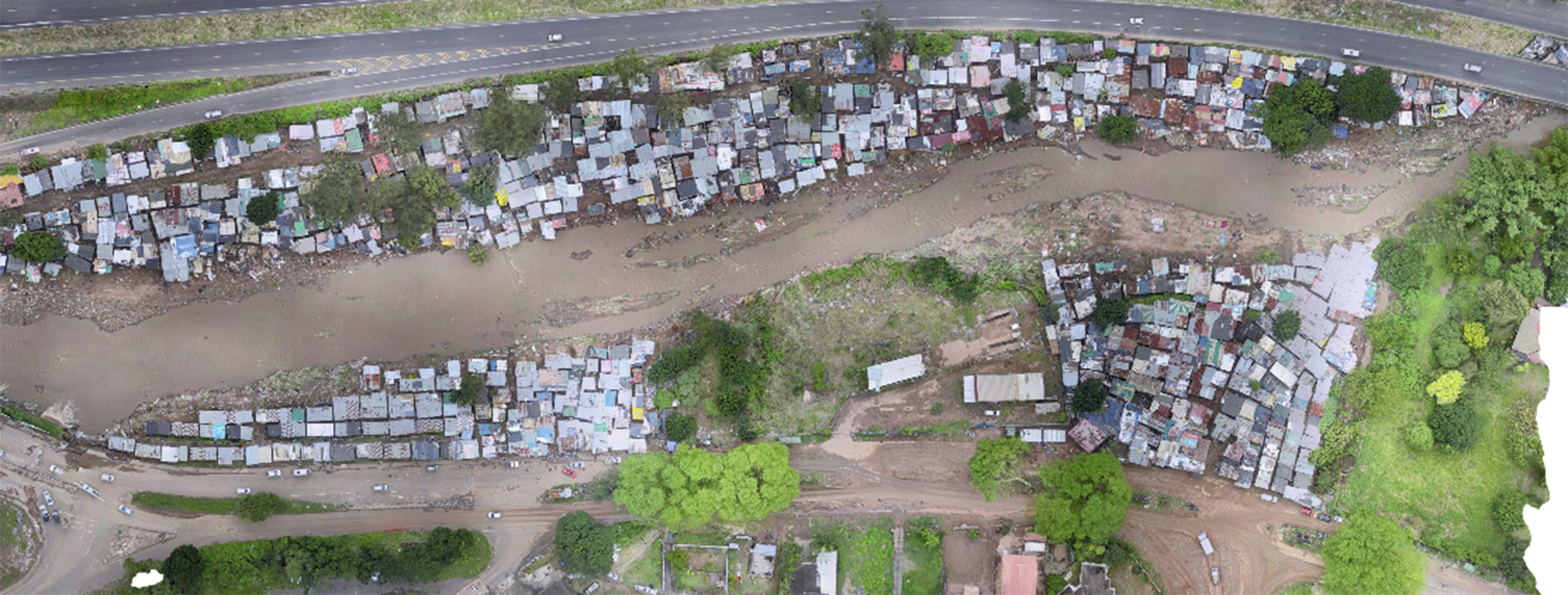
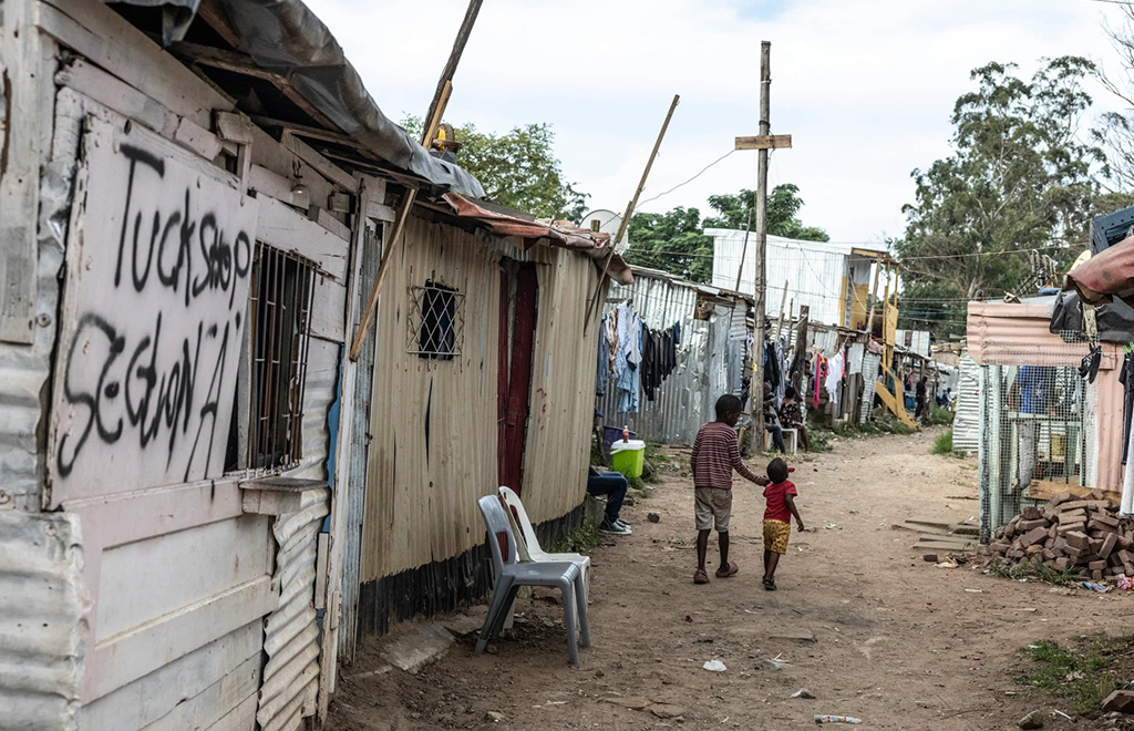
About a quarter of Durban’s residents are in informal settlements, meaning some 300,000 households live in makeshift dwellings in neighborhoods where the city struggles to keep up with service delivery demands, such as water reticulation, sanitation, stormwater systems, electricity provision, and garbage removal. Where these fail, a community is more at risk of flooding during a storm.
As climate impacts escalate, risks will do so too.
Climate analysts say global heating contributed significantly to the April storm’s severity. A storm of this scale would normally happen about once every 40 years, according to a report by the World Weather Attribution initiative that quantified the link between this event and human-caused carbon pollution. But with current levels of warming – already up by 1.2°C relative to pre-industrial conditions – it is more likely to be a one-in-20-year event. But as global heating speeds up, an event of this magnitude will come around even more often.
Durban needs to focus on two things to ready itself for this inevitable future, says a team of South Africa’s leading climate scientists and researchers, writing for the Institute for Security Studies in May 2022.
First, it needs effective early-warning systems in the run-up to disasters. The one trialed at Quarry Road is a case in point.
Second, it needs to address the kind of systemic problems that shape the city’s built environment. These include the many forces that lead to people building informal homes on the banks of a flood-prone river in the first place.
When extreme weather meets urban sprawl

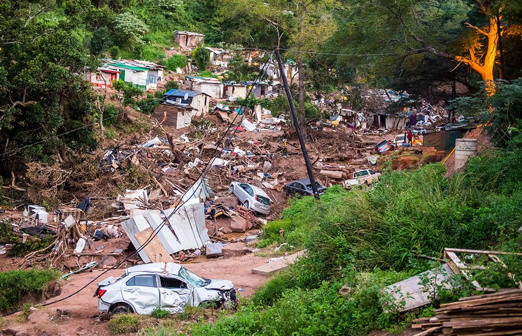
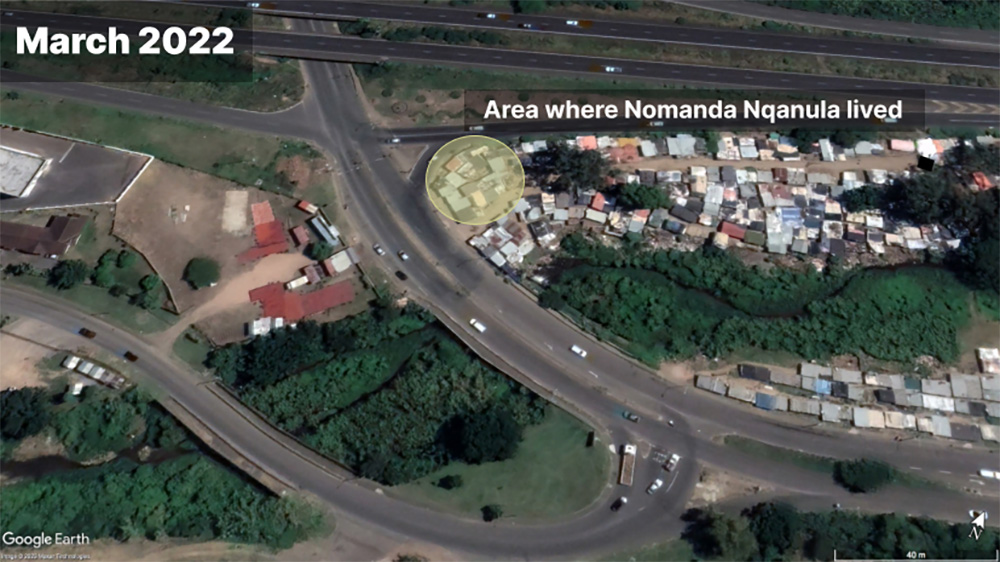
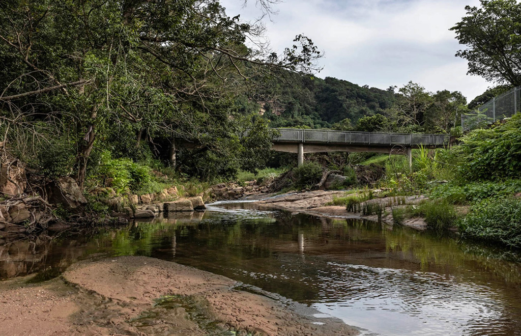
Nqanula thought her house would be safe – it was further from the water’s edge than many others, tucked up against the road on higher ground. But when the torrent needed a new path to the sea, it tore around the bridge, directly through the cluster of homes where she lived.
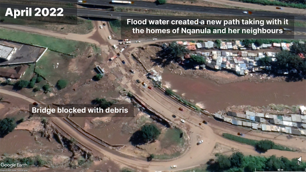
The very structure that was built to allow the river to flow while letting the city tick over around it – and which some Quarry Road families had even built their dwellings under – became the very thing that turned the water into a destroyer.
The built environment increases flood risk, and at the same time is more likely to be destroyed by the force of that very water.
The location of houses, roads, industrial sites, malls, bridges, utility stations and so forth change how rainwater moves through the landscape. When heavy rains hit the natural environment, vegetation, roots, and earth help it seep into the ground, slowing its release into rivers and out to sea. Once the land is capped over with an impervious shell of concrete, asphalt, paving, buildings, and structures like bridges, the natural brakes are gone.
Even with well-considered stormwater drainage, the volume and speed of run-off gets turbocharged.
A city faces the almost impossible task of managing its inherited built environment, with the needs of its fast-growing footprint. It then has the responsibility to climate-proof both.
To do so, Durban needs to identify hazard-exposed land and stop development in these zones, as the climate scientists in ISS Today warn. The local government needs to take charge of all development – even informal sprawl– by limiting it to safe areas. It needs to consult communities in high-risk areas, such as those in Quarry Road, and help them move to safer settlements, which the city will need to build. Exposed infrastructure needs flood protection and new infrastructure should be planned, designed, and built with the risk of an extreme flooding in mind.
The city knows this and outlines its plans in various policy documents, such as its climate change and resilience strategies. For instance, it plans to upgrade 80% of drainage infrastructure by 2030, and 100% of it by 2050. Durban hopes to restore 7,400 km of river corridors to be “clean, safe, healthy, and climate resilient” by mid-century.
Rolling this out, though, happens within the limitations of tight budgets, contested political interests, institutional capacity, and the ongoing housing and service delivery backlogs in a city whose population keeps growing.
Natural ‘airbag’ protects against weather shocks
The damming of the Quarry Road bridge by splintered trees and solid waste was not an isolated incident. Culvert blockages like this are common there, forcing rivers to break their banks and gut surrounding infrastructure.
Durban is a diverse natural landscape, its steep rolling hills broken by winding river valleys that slump to a coastal plain. It is in the wettest and most humid part of the country, getting more than 1,000 mm of rain in summer. Its 7,400 km of streams and rivers, running through 18 catchments, are heavily damaged by urban sprawl: solid waste dumping, leaks from sewerage works and pipes, industrial pollution, sand mining, and invasive alien plants.
Heavy rainfall brings more water into a river system, flowing faster, because of the hard surfaces of the altered landscape, and the rivers clogged with alien plants and litter, the stormwater drainage systems and river culverts block easily, and often.
Understanding that healthy rivers and wetlands are essential to flood-proof a city, the municipality plans to roll out a community-based river restoration project that draws on an initiative that’s been piloted across 300 km of river in parts of Umlazi, Inanda, Ntuzuma, and KwaMashu, all less developed neighborhoods on the outskirts of the city. The Sihlanzimvelo program is run by the city and draws on locals, assigning groups of up to eight people to tend to their own 5 km stretch of river, where they clear overgrown plants, collect litter, report pollution and repair eroded banks.
O’Donoghue, from eThekwini’s climate protection branch, says the plan is to scale this up, city-wide. By his estimates, an investment of R7.5-billion (US$400 million) in river restoration over two decades will prevent R1.9-billion (US$54.169 million USD) in infrastructure damage caused by culvert blockages alone. But, he says, it could also create upward of 9,000 jobs.
A restoration project like this, applied to a river system like the Palmiet, would provide a natural “airbag” that would protect Quarry Road from the kind of weather shock that washed away 400 homes in the settlement in April.
The Palmiet Nature Reserve is just 15 minutes drive inland of Quarry Road. It is 90 hectares of relatively unspoiled forests, meandering rivers that tumble over waterfalls, and grasslands higher up. A nature reserve might seem like a luxury in a city that urgently needs land for new housing. But a recent study into the value of Durban’s natural spaces –rivers, wetlands, forests, soils, and the like– estimates that its rivers provide a water flow regulation service valued at R29.5 million (US$1.616 million) annually.
Protecting unspoiled ecosystems and green belts – even altered ones – doesn’t just give people a beautiful place to relax and play. It also provides a suite of “ecosystem services” that absorb extreme weather shocks. Plants, trees in particular, are natural air conditioners that offset the urban heat island effect, which will make heat waves more lethal. Healthy wetlands and rivers – the surrounding vegetation, and their soil – smooth out the release of rainwater into rivers, which reduces flooding, erosion, and river siltation. Dunes, estuaries, and mangroves soften the force of ocean surges during storms, buffering against erosion and wave damage to infrastructure.
Stakeholders must work together
To flood-proof itself, particularly the third of its residents living in informal neighborhoods like Quarry Road, a city needs a plan.
On paper, Durban has one. The 2019 Climate Action Plan lists what’s needed to tackle the flooding problem: an early-warning system; the one-in-100-year flood line map that, when drawn together with climate projections, allows for better planning and management in flood-risk areas; and the many state partnerships necessary to restore and conserve ecological infrastructure.
The intention is to limit and discourage development in flood-risk areas and protect existing infrastructure from flood risk. It lists the actions necessary to keep river corridors healthy and keep the ecological infrastructure working.
Elsewhere, the plan flags the need to move communities out of flood-risk areas and house them appropriately in properly serviced areas.
This document dovetails with the city’s many other plans and policies, such as the 2017 resilience strategy, its spatial development framework, and the integrated development plan, a complex negotiation that needs to align with various other local, provincial and national government laws and constitutional obligations.
Dr. Debra Roberts, a leading South African climate and urban biodiversity scientist working in eThekwini, is the city’s chief resilience officer and helps coordinate resilience and sustainability “workstreams” across the municipality. O’Donoghue, meanwhile, oversees the city’s climate adaptation response. The city also has a senior climate scientist, Smiso Bhengu, in its ranks. Their expertise, and the positions they hold within the city institution, allow them to link different government departments whose responsibilities overlap around resilience or climate-focused initiatives. It also helps the municipality coordinate with non-state bodies, such as academics, civil society, and the private sector, to rally around shared-partnership initiatives.
The Palmiet Catchment Rehabilitation Project is one such project and an example of how climate literacy within a city’s administration – and the resulting planning and institutional arrangements – makes it into the real world. This project is geared towards addressing flood risk along the catchment, specifically for the Quarry Road community, using social, governance and environmental levers. It draws in city personnel, university researchers, and the local community. The community-based early-warning system that saved many lives on the night of April 11 is one cog in the wheel of this complex machinery.
Private developers perpetuate apartheid-era inequality
That April, about 20 km uphill of Quarry Road, at the newly minted Cornubia business-industrial-residential park, an emergency of a different kind was unfolding.
A temporary pollution holding dam, built a year earlier to capture the toxic run-off from a fire that destroyed a warehouse filled with agrichemicals and poisons, was flooding. A cocktail of heavy metals, carcinogens, and pesticides was spilling into the Ohlanga River, killing vegetation and fish, and forcing the city to consider closing the beaches at the river mouth.
It will take years to fully understand the health and environmental fallout, environmental justice activists warn, but the impact on property prices and the city’s housing plans is likely to be swifter.
The April floods destroyed 13,500 homes across Durban, a third of which were in informal settlements, and the city had to shelter 7,245 people in halls and care centers immediately after the event. By December, many were still homeless.
After a disaster like this, the city has to help families rebuild their homes, or place them in state-subsidized housing, which means fast-tracking developments to meet the existing housing backlog.
The farmland surrounding Cornubia, much of which is owned by the sugarcane conglomerate Tongaat Hulett, is earmarked for some of this development.
Activists worry that history will repeat itself here: that the contaminated land, some of which falls into Cornubia’s mixed-income housing plan but may no longer be appealing to private property buyers, could be offloaded on to the government at a bargain-basement price, and used to relocate flood evacuees such as those from Quarry Road.
South Africa’s apartheid-era laws split the city along race lines – a proxy for class – leaving cities with a spatial divide that haunts them to this day. The 1958 Group Areas Act pushed poorer people of color into Durban’s most marginal and often flood-prone areas. Three decades after these laws were dismantled, Durban’s residential divide is largely unchanged.
Where law once segregated the city, locking in a spatial divide between rich and poor, now the private property market maintains it.
Environmental racism isn’t unique to South Africa. Around the world, poor communities of color tend to wash up in the most environmentally marginal, degraded and polluted parts of many cities.
Cornubia is a public-private partnership between Tongaat Hulett and the eThekwini municipality and is billed as one of the “catalytic projects” that will help meet the region’s growth and development goals.
It will include a new city center, a fresh start now that Durban’s aging central business district (CBD) has lost its shine, falling into disrepair following municipal neglect and investor flight, much as Sandton replaced Johannesburg’s neglected CBD.
But environmental and planning lawyer Jeremy Ridl warns that the corporation’s power as a profit-motivated landowner and developer has allowed it to steer Durban’s spatial planning in its own interests.
Ridl is heading a coalition of affected communities and civil society working with the government and private agrichemical firm United Phosphorus Limited (UPL), which owned the destroyed warehouse, to ensure transparency and accountability in the post-fire mop-up. He flags Cornubia, and the pollution bedeviling the site, as an example of how the private sector and the free market maintain Durban’s inherited inequality gap and the environmental racism that plagues it. This distorted power relationship can undermine even the most competent city officials, institutions, and policies.
Many of Durban’s development challenges, which apartheid played a significant role in creating, come together with fast-paced urbanization, free market economics, and the climate crisis to create a perfect storm that threatens resilience, writes Roberts in a co-authored report on the city’s resilience strategy journey.
Meanwhile, the health and environmental issues following the chemical warehouse fire at Cornubia seem far from resolved. Environmental journalist Tony Carnie’s December 2022 reporting in Daily Maverick showed that the ground beneath the damaged warehouse contains dangerously high levels of pesticides, carcinogens and heavy metals, and there’s a risk these toxins could make their way into the groundwater.
These findings are a reminder of the need for rigorous ongoing monitoring at the site and transparency in management and further development in the contamination zone.
But, is it better?
When the flood hit Nqanula’s house, it took everything away. She was left with nothing but the sodden clothes she spent the night in, huddled on that service station forecourt waiting out the storm.
It took her independence too, she says, and her confidence and happiness.
Someone brought blankets and soup the next day, but Nqanula remembers that emergency vehicles couldn’t get in at first because the roads and bridges were so badly damaged. On the second night, they slept on the floor at a nearby school, until they were moved to another hall. Eight months later, many of the Quarry Road evacuees were still living in care centers and relying on the city or its civil society partners for food and other provisions.
Nqanula decided she’d rather find somewhere to rent. She needed space to heal, to pray, to “have herself back,” away from the traumatized crowd.
This isn’t the first time she’s had to put her life back together since she moved to Quarry Road in 2013 – new clothing, new furniture, a new bed, everything. In 2019, a flood destroyed her house, but she wanted to stay in the community, so she bought a shack on the other side of the river. It was higher up, further from the water.
In Nqanula’s early years in Quarry Road, her two sisters lived with her. But between them, they decided to spread the risk. Informal homes are easily damaged by flood or fire. If they lived between two homes, they’d have a backup should one be destroyed; so one sister moved to Glenwood, about 8 km away. After the April floods, Nqanula sent her younger sister there, while she rented a place a 15-minute walk from her old home.
People settle in flood-exposed places for many reasons: they want to be close to jobs and the other opportunities that come with being near the heart of a bustling city, even if they understand there might be weather-related risks. None can afford a suburban house, and the waiting list for a state-subsidized house is endless. Some build their homes on a site that looks ideal during the dry season, unaware of what will come with the rains. Many also have a strong connection with their community and don’t want it torn apart in a relocation process.
Quarry Road is flagged as a priority for relocation to a safer, properly serviced site. But it’s a slow process and needs community buy-in. In the meantime, the city is trying to improve basic services – an “in-situ upgrade,” they call it – with better garbage removal, communal water taps, pit toilets and ablution blocks and stormwater management. Flood-proofing a community is, after all, about more than just putting a solid roof over someone’s head. Homes need to be in a neighborhood with working stormwater drains, refuse removal, water reticulation and lights on.
Until then, many from Quarry Road are stuck in limbo.
If Nqanula could ask for one thing, it’s that the municipality could give all of them a piece of land “away from the water”. They can build their own homes, she says, even if it takes a long time.
Just a small, safe piece of land. – Rappler.com
This story was originally published in Daily Maverick (South Africa) and is republished within the Human Journalism Network program supported by the International Center for Journalists.
First originally published by The Outlier.

Add a comment
How does this make you feel?


There are no comments yet. Add your comment to start the conversation.