SUMMARY
This is AI generated summarization, which may have errors. For context, always refer to the full article.
MANILA, Philippines (UPDATED) – Leonor Pineda, a resident of San Fernando, Pampanga, could still remember the thrill she felt 27 years ago.
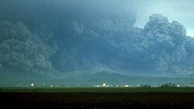
It was June 11, 1991 when she first saw minor emissions from Mount Pinatubo. While it was considered an active volcano, Pinatubo has been dormant for about 600 years already. It was the first time the 27-year-old mother of two has ever seen a volcano acting like that. The emissions then were still small at the time, not enough to cause panic. From her office window, Pineda saw a convoy of American soldiers from Clark Air Base in Pampanga. They were evacuating their bases, just 16 kilometers away from the volcano, as Pinatubo continued showing signs of unrest. Even on June 15, as some people stayed in their homes aware that a major eruption could happen anytime, Pineda and many like her still went to their respective offices. At lunchtime, as the situation was getting worse, her boss asked everyone to go home. By the time she reached home at around 1:42 pm she remembered seeing a mushroom-like cloud over Mt Pinatubo. Then darkness fell. She heard rocks fall on their roof. She felt the ground move from time to time. “Akala ko talaga katapusan na ng mundo,” she said. (I really thought it was the end of the world.) Sister Emma and her early warnings Mount Pinatubo did not fail to warn communities living near the slopes before its imminent eruption. In March 1991, months before the volcano unleashed its full fury, a group of Aetas living in the upper slopes of Mount Pinatubo felt minor earthquakes (with magnitudes not greater than 4) around the volcano. Volcanologists called these swarms, according to Winchelle Sevilla, officer-in-charge of Volcano Monitoring and Eruption Prediction Division (VMEPD) of the Philippine Institute of Volcanology and Seismology (Phivolcs). Soon after, the group, led by Sister Emma, a missionary based in that area, went to Raymundo Punongbayan, then director of Phivolcs, to report about their observation. Punongbayan immediately sent a quick response team to observe the volcano.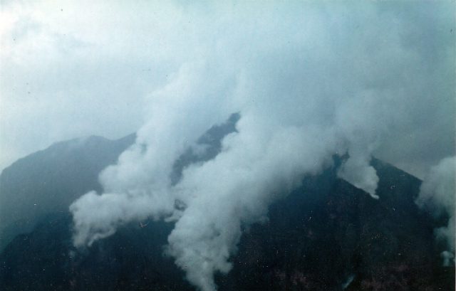
In April of that same year, Sister Emma returned to Phivolcs to report again about their new observation, this time, of steam explosions in some parts of Mount Pinatubo.
Seismic networks were then set up in the vicinity to locate the source of the swarms, according to Sevilla. Experts from the US Geological Survey (USGS) also came to help the agency.
By June 1991, the swarms became more frequent. And if in May, the swarms felt were scattered in different parts of the volcano, this time, they were concentrated in a single area. Phivolcs raised the alert status to 4 and a danger zone of 10 kilometers from the volcano was set. “Parang nandoon na siya [swarms] halos sa ilalim ng bulkan kasi umaakyat na yung magma,” Sevilla said. (The swarms seemed to be coming from below the volcano itself because the magma was starting to rise.) By June 7, a lava dome appeared at the summit of Mount Pinatubo, which meant that an eruption was about to happen. Two days after, Phivolcs raised its alert status to 5, and the danger zone was extended to 20 kilometers. From June 12-14, a series of eruptions began. ‘Cataclysmic eruption’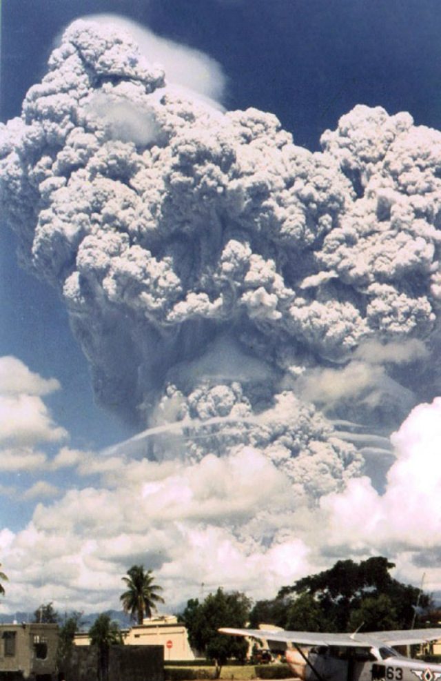
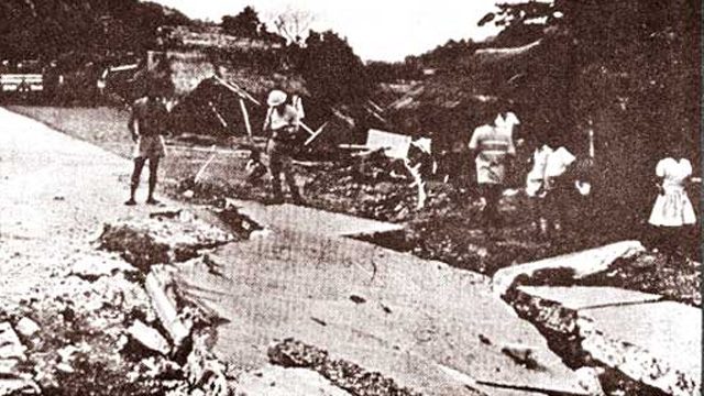
Major lahar flows continued to affect nearby cities for the next 6 years. Even today, minor lahar flows still affect some provinces during the Habagat (southwest monsoon) season, Abigania said.
Early evacuation
Despite the extent of the destruction, the number of casualties from the Mount Pinatubo eruption was relatively low, according to Sevilla.
Given an increasing number of people living in areas near volcanoes, the death toll from volcanic eruptions in the 20th century could potentially reach thousands. Pinatubo, despite being one of the largest, had less.
Here is a list of some of the most devastating eruptions of the 20th century:
| Year | Volcano | No. of Casualties |
| 1985 | Nevado del Ruiz (Colombia*) | 23, 000 |
| 1982 | El Chichon (Mexico) | 2, 000 |
| 1980 | Mount St. Helens (United States) | 57 |
| 1963 | Agung (Indonesia) | 1, 184 |
| 1951 | Lamington (Papua New Guinea) | 2, 942 |
| 1951 | Hibok-Hibok (Philippines) | 500 |
According to Phivolcs data, the 1991 eruption had affected about 1.25 million inhabitants. 717 people lost their lives – 281 of whom died indirectly from the eruption, 83 from lahars, and 353 from exposure to diseases at evacuation centers.
While a number of people died, reports say that about 5,000 lives were saved from the eruption.
“The people living in the lowlands around Mount Pinatubo were alerted to the impending eruption by the forecasts, and many fled to towns at safer distances from the volcano or took shelter in buildings with strong roofs,” according to the USGS report.
As early as April of that year, 2,000 people were already being evacuated, according to Phivolcs data.
“Sa volcano, ang magagawa mo lang diyan ay lumayo ka as far as possible. Hayaan mo lang siyang pumutok pero ang gagawin mo i-evacuate mo lahat ng mga nakatira doon as much as possible,” Sevilla said.
(With a volcano, what you can do is to just move away from it as far as possible. Just let it erupt but you should evacuate everyone as much as possible.)
Close coordination between government agencies and communities near the volcano also helped minimize the number of casualties.
“It really helped that the communities reported what they have observed. They knew their surroundings better, so the information coming from them were really important,” Abigania said. The inputs of experts have certain limits, unless, they too, will give their inputs, Abigania explained.
It would take centuries for Mount Pinatubo to erupt with that same amount of force again. But the Phivolcs reminds the public, especially those living near volcanoes to not become complacent.

Phreatic or sudden steam-driven eruptions can happen anytime, according to Phivolcs director Renato Solidum. This is why a number of active volcanoes already have designated a Permanent Danger Zone (PDZ), where human settlement is prohibited. (READ: When mountaineers climb active volcanoes)
So far, there are 5 active volcanoes in the Philippines with PDZs: Mayon (6 km), Taal (whole island), Kanlaon and Bulusan (4 km) and Hibok-Hibok (3 km). These volcanoes frequently erupt, according to Solidum.
“As long as the right ingredients are there – heavy and continuous rainfall plus old volcanic deposits – lahar flow is possible. That holds for any other active volcanoes that we have,” Abigania added. – Rappler.com
Sources: Philippine Institute of Volcanology and Seismology, U.S. Geological Services, The New Wider World by Alison Rae, Neil Anthony Punnet, www.volcano.oregonstate.edu, www.volcanolive.com, various news websites
The Philippine Institute of Volcanology and Seismology (Phivolcs) is a partner of Rappler in Project Agos, a collaborative platform that combines top-down government action with bottom-up civic engagement to help communities learn about climate change adaptation and disaster risk reduction. Project Agos harnesses technology and social media to ensure critical information flows to those who need it before, during, and after a disaster.
Project Agos is supported by the Australian Government.
Editor’s Note: In a previous version of this story we said Nevado del Ruiz was located in Mexico. It is located in Colombia, instead. We have corrected the error.
Add a comment
How does this make you feel?


There are no comments yet. Add your comment to start the conversation.