SUMMARY
This is AI generated summarization, which may have errors. For context, always refer to the full article.

MANILA, Philippines – Scattered rain and thunderstorms will persist in parts of the Philippines until Saturday, April 9, due to the low pressure area (LPA) embedded along the intertropical convergence zone (ITCZ).
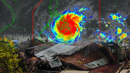
The LPA was last spotted 185 kilometers east northeast of Surigao City, Surigao del Norte, on Friday afternoon, April 8, according to the Philippine Atmospheric, Geophysical, and Astronomical Services Administration (PAGASA).
PAGASA Weather Specialist Raymond Ordinario noted that clouds over the Mindanao area were already slightly thinning, but remain thick in the Visayas.
Still, all of the following areas affected by the LPA and the ITCZ must stay on alert for moderate to heavy rain, which could trigger more floods and landslides:
- Visayas
- Caraga
- Northern Mindanao
- Zamboanga Peninsula
- Mimaropa
- Bicol
- Quezon
The weather bureau is not ruling out the possibility of the LPA developing into the Philippines’ first tropical cyclone for 2022. If it does, it would be given the local name Agaton.
Meanwhile, the tropical cyclone outside the Philippine Area of Responsibility (PAR), a tropical storm with the international name Malakas, was located 2,215 kilometers east of Mindanao on Friday afternoon.
Tropical Storm Malakas is moving north northwest at only 10 kilometers per hour (km/h). It could enter PAR either on Monday, April 11, or Tuesday, April 12, Ordinario said.
So far, Malakas has maximum sustained winds of 75 km/h and gustiness of up to 90 km/h. It may strengthen further in the coming days before entering PAR.
PAGASA earlier said Malakas appears unlikely to make landfall.
Rain will also persist in the northern part of the country until Saturday due to the northeasterly surface windflow. PAGASA warned that flash floods and landslides could hit these areas:
- Cagayan Valley
- Apayao
- Kalinga
- Ifugao
- Mountain Province
- Aurora
The rest of Luzon, including Metro Manila, will only have isolated rain showers or thunderstorms on Saturday. – Rappler.com
Add a comment
How does this make you feel?


There are no comments yet. Add your comment to start the conversation.