SUMMARY
This is AI generated summarization, which may have errors. For context, always refer to the full article.
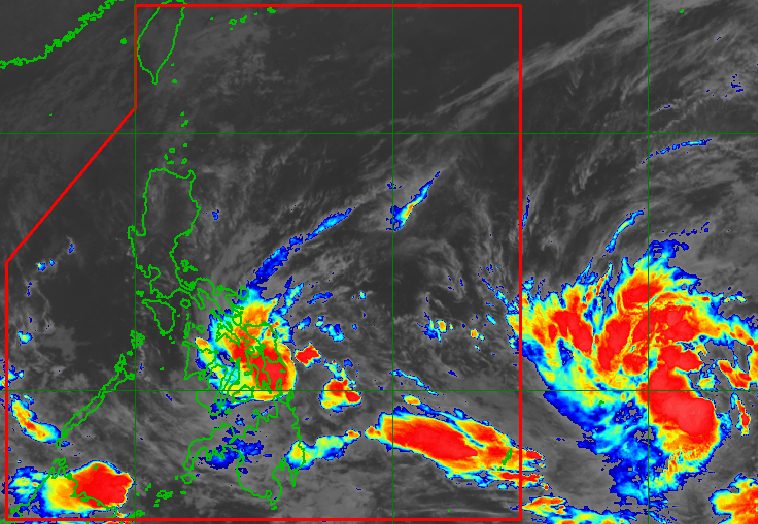
MANILA, Philippines – Rain from Tropical Depression Agaton will be torrential in at least three provinces, the state weather bureau warned late Saturday evening, April 9.
The Philippine Atmospheric, Geophysical, and Astronomical Services Administration (PAGASA) said Agaton was located 115 kilometers east southeast of Guiuan, Eastern Samar, its location practically unchanged as it remains almost stationary.
The tropical depression is likely to stay almost stationary until Monday, April 11, but the possibility of landfall in Eastern Samar is not being ruled out.
Agaton maintained its strength late Saturday evening, with maximum sustained winds of 55 kilometers per hour and gustiness of up to 70 km/h. But it is still seen to intensify into a tropical storm within the next 12 to 24 hours.
PAGASA warned that scattered to widespread floods and landslides are expected in areas affected by Agaton. The weather bureau updated its rainfall forecast as of 11 pm on Saturday:
Saturday evening, April 9, until Sunday evening, April 10
Heavy to intense rain, with at times torrential rain
- Eastern Samar
- Samar
- Dinagat Islands
Moderate to heavy rain, with at times intense rain
- rest of Eastern Visayas
- Surigao del Norte
- northern and central parts of Cebu including Bantayan and Camotes Islands
Light to moderate rain, with at times heavy rain
- Masbate
- Sorsogon
- rest of Visayas
- rest of Mindanao
Sunday evening, April 10, until Monday evening, April 11
Moderate to heavy rain, with at times intense rain
- Eastern Visayas
- Dinagat Islands
- Surigao del Norte
- northern part of Cebu including Bantayan and Camotes Islands
Light to moderate rain, with at times heavy rain
- Masbate
- Sorsogon
- rest of Visayas
- rest of Mindanao
Signal No. 1 is still raised in four areas as of 11 pm on Saturday. These areas are experiencing strong winds which pose “minimal to minor threat to life and property”:
- Eastern Samar
- Dinagat Islands
- Siargao Island
- Bucas Grande Island
With Agaton set to intensify into a tropical storm, PAGASA said there is a “moderate likelihood” of parts of Eastern Visayas and Caraga being placed under Signal No. 2. Areas not yet under a tropical cyclone wind signal could also be placed under Signal No. 1.

Agaton could begin turning northeast on Monday evening or on Tuesday morning, April 12, as it interacts with the incoming Tropical Storm Malakas, which remains outside the Philippine Area of Responsibility (PAR).
Malakas, located 1,815 kilometers east of Mindanao late Saturday evening, is moving northwest at 20 km/h. It could enter PAR late Monday or early Tuesday and would be given the local name Basyang.
As of late Saturday evening, Malakas still had maximum sustained winds of 75 km/h and gustiness of up to 90 km/h. But it is expected to strengthen into a severe tropical storm on Sunday, April 10, and then into a typhoon on Sunday evening or Monday morning. It could reach a peak intensity of 155 km/h on Tuesday.
Its stay inside PAR is likely to be short. PAGASA expects Malakas or Basyang to leave PAR late Tuesday or early Wednesday, April 13, which means it would only be in the region for around a day.
This brief stay also means Malakas will not directly affect the weather in the Philippines. But PAGASA said it may “influence the movement and development” of Agaton.
Agaton could weaken into a remnant low by late Tuesday as it gets absorbed by Malakas or Basyang.

Meanwhile, PAGASA reminded the public that sea travel is still risky due to Agaton and the northeasterly surface windflow.
Rough to very rough seas due to Agaton
Waves 2.8 to 4.5 meters high; conditions risky for most vessels
- seaboards of areas under Signal No. 1
- northern and eastern coastal waters of Northern Samar
Rough to very rough seas due to the northeasterly surface windflow
Waves 2.8 to 4.5 meters high; small vessels advised not to sail, larger vessels alerted against big waves
- northern and western seaboards of Northern Luzon (Batanes, Babuyan Islands, northern coast of Cagayan, Ilocos Norte)
Moderate to rough seas
Waves 1.2 to 3.4 meters high; conditions risky for small vessels
- remaining seaboards of the Philippines
The weather bureau is also monitoring a low pressure area (LPA) along the PAR boundary, located 445 kilometers west southwest of Puerto Princesa City, Palawan, late Saturday evening.
PAGASA Weather Specialist Benison Estareja said the LPA only has a slim chance of developing into a tropical depression, but it is bringing rain to Palawan. – Rappler.com
Add a comment
How does this make you feel?


There are no comments yet. Add your comment to start the conversation.