SUMMARY
This is AI generated summarization, which may have errors. For context, always refer to the full article.
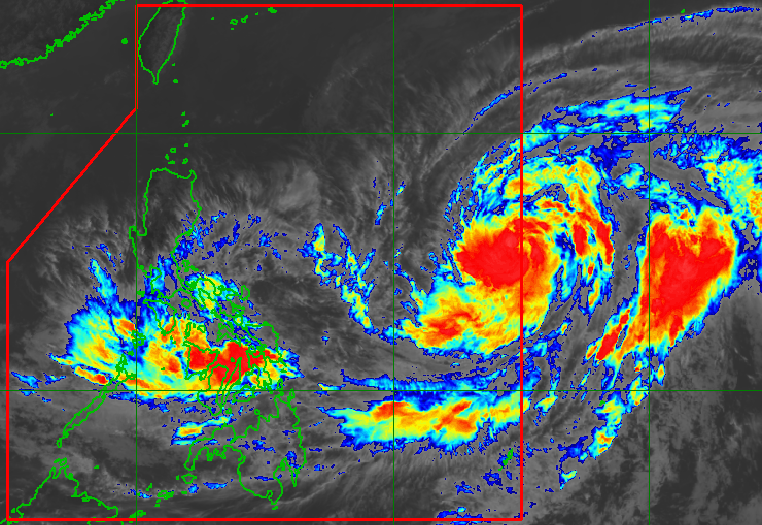
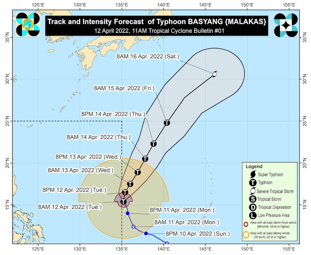
MANILA, Philippines – The tropical cyclone with the international name Malakas intensified from a severe tropical storm into a typhoon at 8 am on Tuesday, April 12, two hours before it entered the Philippine Area of Responsibility (PAR) at 10 am.
With its entry, Malakas was given the local name Basyang, as the country’s second tropical cyclone for 2022. Typhoon Basyang joins Tropical Depression Agaton (Megi) inside PAR.
In a bulletin released shortly before noon on Tuesday, the Philippine Atmospheric, Geophysical, and Astronomical Services Administration (PAGASA) said Basyang was located 1,435 kilometers east of Southern Luzon, moving north northwest at 20 kilometers per hour (km/h).
So far, Basyang has maximum sustained winds of 120 km/h and gustiness of up to 150 km/h. PAGASA expects the typhoon to reach a peak intensity of 150 km/h on Wednesday morning, April 13.
Basyang will only stay near the PAR boundary, so it is not expected to directly affect weather in the Philippines. Its stay inside PAR will also be brief and it may already leave on Tuesday evening.
PAGASA warned, however, that swells resulting from Basyang could cause moderate to rough seas in the northern and eastern seaboards of Luzon and the eastern seaboards of the Visayas and Mindanao. Conditions may be risky for small vessels.
Within the next 24 hours, Agaton – by then already a remnant low – is also seen to be absorbed by Basyang.
As of late Tuesday morning, Agaton was in the vicinity of Balangiga, Eastern Samar, slowly moving east. The tropical depression continues to have maximum sustained winds of 45 km/h, while its gustiness is up to 75 km/h.
PAGASA maintained its rainfall forecast for Agaton, covering the rest of Tuesday. The weather bureau advised the public to remain on alert for more floods and landslides.
Moderate to heavy rain, with at times intense rain
- Eastern Visayas
- northern and central parts of Cebu including Bantayan and Camotes Islands
- Aklan
- Capiz
- Iloilo
- Antique
- Guimaras
- northern and central parts of Negros Occidental
- northern and central parts of Negros Oriental
- Bicol
Light to moderate rain, with at times heavy rain
- rest of Visayas
- Mimaropa
- Quezon
- Dinagat Islands
- Zamboanga del Norte
The same areas remain under Signal No. 1 as of 11 am on Tuesday:
- southern part of Masbate (Dimasalang, Cawayan, Palanas, Placer, Cataingan, Esperanza, Pio V. Corpuz)
- Eastern Samar
- Samar
- Northern Samar
- Biliran
- Leyte
- Southern Leyte
- northeastern part of Cebu (Daanbantayan, Medellin, Bogo City, Tabogon, Borbon, Sogod) including Camotes Island
- Dinagat Islands
Areas under Signal No. 1 are experiencing strong winds that pose a “minimal to minor threat to life and property.”
Within the next 6 to 12 hours, Agaton will continue to linger in the Samar-Leyte area, according to PAGASA. Then the tropical depression could turn more east southeast toward the Philippine Sea beginning Tuesday evening or Wednesday morning.
Its track may still change, however, given the “continuing erratic nature of its movement,” PAGASA said.
Agaton is likely to weaken into a remnant low on Tuesday or Wednesday, “due to the combined effects of land interaction, increasing vertical wind shear, and the effects of the upper-level outflow of Typhoon Basyang.”
The remnant low would then be absorbed by Basyang.
Earlier, Agaton made landfall twice:
- Calicoan Island, Guiuan, Eastern Samar – 7:30 am on Sunday, April 10 (as a tropical storm)
- Basey, Samar – 4 pm on Monday, April 11 (as a tropical depression)

Sea travel remains dangerous on Tuesday.
Rough seas
Waves 2.8 to 4 meters high; conditions risky for most vessels
- seaboards of areas under Signal No. 1
Moderate to rough seas
Waves 1.2 to 3.7 meters high; conditions risky for small vessels
- remaining seaboards of the Philippines, especially the northern and eastern seaboards of Luzon and the eastern seaboards of the Visayas and Mindanao
– Rappler.com
Add a comment
How does this make you feel?


There are no comments yet. Add your comment to start the conversation.