SUMMARY
This is AI generated summarization, which may have errors. For context, always refer to the full article.
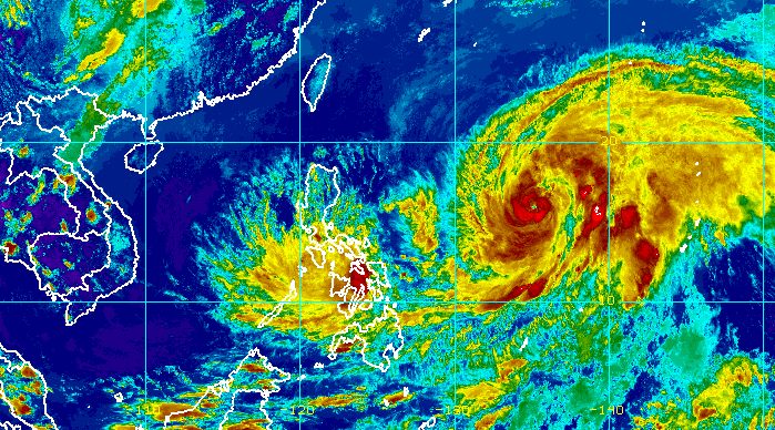
MANILA, Philippines – Tropical Depression Agaton (Megi) was almost stationary over Llorente, Eastern Samar, on Tuesday afternoon, April 12, maintaining its extremely slow pace inside the Philippine Area of Responsibility (PAR).
In contrast, the presence of Typhoon Basyang (Malakas) inside PAR lasted only 3 hours, as it left PAR at 1 pm on Tuesday after its entry at 10 am. It only stayed along the PAR boundary and did not directly affect weather in the country.
The Philippine Atmospheric, Geophysical, and Astronomical Services Administration (PAGASA) said in a briefing past 5 pm on Tuesday that Agaton maintained its strength, with maximum sustained winds of 45 kilometers per hour and gustiness of up to 75 km/h.
Rainfall warnings remain in effect in the same areas, given that the tropical depression is hardly moving. Floods and landslides are still possible, PAGASA warned.
Moderate to heavy rain, with at times intense rain
- Eastern Visayas
- northern and central parts of Cebu including Bantayan and Camotes Islands
- Aklan
- Capiz
- Iloilo
- Antique
- Guimaras
- northern and central parts of Negros Occidental
- northern and central parts of Negros Oriental
- Sorsogon
- Masbate
Light to moderate rain, with at times heavy rain
- rest of Visayas
- rest of Bicol
- Mimaropa
- Quezon
- Dinagat Islands
- Zamboanga del Norte
The following areas remain under Signal No. 1, still experiencing strong winds that pose a “minimal to minor threat to life and property”:
- Eastern Samar
- Samar
- Northern Samar
- Biliran
- Leyte
- Southern Leyte
- Camotes Island
- Dinagat Islands
Rough seas are also expected in the seaboards of areas under Signal No. 1. Waves are 2.8 to 4 meters high, making travel risky for most vessels.

Earlier, Agaton made landfall twice:
- Calicoan Island, Guiuan, Eastern Samar – 7:30 am on Sunday, April 10 (as a tropical storm)
- Basey, Samar – 4 pm on Monday, April 11 (as a tropical depression)
In the next 6 to 12 hours, Agaton could slowly move east, then turn more east southeast toward the Philippine Sea. But PAGASA said the tropical depression’s movement continues to be erratic and may still change.
Agaton remains likely to weaken into a remnant low within 24 hours, “due to the combined effects of land interaction, increasing vertical wind shear, and the effects of the upper-level outflow of Typhoon Basyang.”
The remnant low would then be absorbed by Basyang, now outside PAR.
Basyang was last spotted 1,400 kilometers east of Central Luzon late Tuesday afternoon, slowly moving north northwest.
The typhoon intensified further, with its maximum sustained winds increasing from 120 km/h to 130 km/h. It now has gustiness of up to 160 km/h from the previous 150 km/h.
PAGASA said Basyang could reach a peak intensity of 155 km/h on Wednesday afternoon, April 13.
Though Basyang is already outside PAR, the weather bureau warned that swells from the typhoon can still cause moderate to rough seas in the northern and eastern seaboards of Luzon and the eastern seaboards of the Visayas and Mindanao. Conditions may be risky for small vessels.

Agaton and Basyang are the Philippines’ first and second tropical cyclones for 2022. While tropical cyclones are not as frequent during the dry season, they do occur. – Rappler.com
Add a comment
How does this make you feel?


There are no comments yet. Add your comment to start the conversation.