SUMMARY
This is AI generated summarization, which may have errors. For context, always refer to the full article.
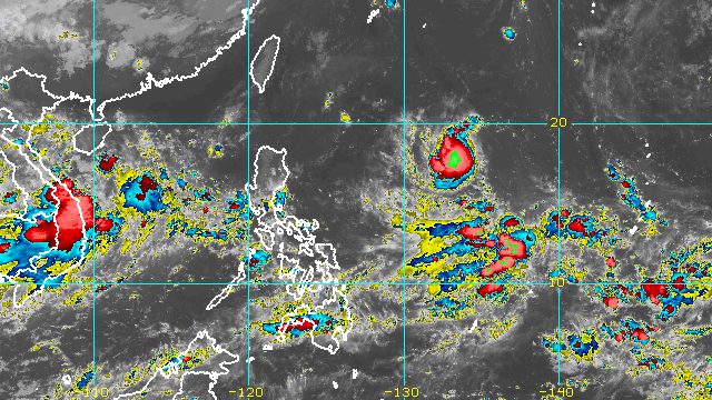
MANILA, Philippines – Tropical Storm Karding maintained its strength as it started inching west over the Philippine Sea on Thursday evening, September 22.
The westward shift means Karding is now heading for Philippine landmass, but at a slow pace.
The tropical storm remained 1,320 kilometers east of Northern Luzon on Thursday evening, said the Philippine Atmospheric, Geophysical, and Astronomical Services Administration (PAGASA) in its 11 pm bulletin.
Karding is expected to continue moving west while speeding up until it makes landfall in the east coast of Northern Luzon or Central Luzon on Sunday, September 25.
Then it would cross Northern Luzon before emerging over the West Philippine Sea on Monday, September 26.
As of Thursday evening, Karding continued to have maximum sustained winds of 65 kilometers per hour and gustiness of up to 80 km/h.
But it is still likely to intensify over the Philippine Sea and may strengthen into a severe tropical storm before landfall.
Even before Karding’s possible landfall on Sunday, Northern Luzon and Central Luzon could already have rain as early as Saturday evening, September 24, or early Sunday morning.
The rain may trigger isolated to scattered floods and landslides.
Tropical cyclone wind signals are also likely to be raised for Northern Luzon, Central Luzon, and some parts of Southern Luzon.
PAGASA said areas in the eastern parts of Northern Luzon and Central Luzon could be placed under Signal No. 1 as early as Friday evening, September 23, or early Saturday morning.
If Karding does reach severe tropical storm status, the highest possible wind signal would be Signal No. 3.
Karding may also cause moderate to rough seas in the seaboards of Northern Luzon and the eastern seaboard of Central Luzon beginning Sunday.
Waves will be 1.2 to 3.8 meters high, which may be risky for small vessels.

Karding is the Philippines’ 11th tropical cyclone for 2022.
It is also the third tropical cyclone for September, after Typhoon Inday (Muifa) and Super Typhoon Josie (Nanmadol). Inday and Josie did not make landfall in the country.
PAGASA expects 7 to 11 tropical cyclones to enter or develop inside the Philippine Area of Responsibility from September 2022 to February 2023. Per month, these are the weather bureau’s estimates:
- September 2022 – 2 or 3
- October 2022 – 2 to 4
- November 2022 – 2 or 3
- December 2022 – 1 or 2
- January 2023 – 0 or 1
- February 2023 – 0 or 1
– Rappler.com
Add a comment
How does this make you feel?


There are no comments yet. Add your comment to start the conversation.