SUMMARY
This is AI generated summarization, which may have errors. For context, always refer to the full article.
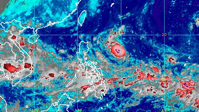
MANILA, Philippines – Tropical Storm Karding (Noru) maintained its strength on Friday evening, September 23, but the weather bureau warned that the tropical cyclone is still expected to intensify before making landfall in Northern Luzon.
“While current forecast scenario shows that Karding may make landfall as a severe tropical storm, the possibility that this tropical cyclone will reach typhoon category shortly before reaching land is not ruled out,” the Philippine Atmospheric, Geophysical, and Astronomical Services Administration (PAGASA) said in its 11 pm bulletin on Friday.
Karding continues to move over the Philippine Sea. It was last spotted 895 kilometers east of Northern Luzon, moving west southwest at the same speed of 15 kilometers per hour (km/h).
It is heading for the east coast of Isabela or Aurora, where it could make landfall on Sunday morning or afternoon, September 25. Then it may cross Northern Luzon throughout Sunday before emerging over the West Philippine Sea late Sunday evening or early Monday morning, September 26.
“Frictional effects of the rugged terrain of Northern Luzon may result in some slight weakening, although Karding will likely be at severe tropical storm category once it emerges over the West Philippine Sea,” PAGASA said.
As of Friday evening, Karding still had maximum sustained winds of 75 km/h and gustiness of up to 90 km/h.
Under PAGASA’s classification, a severe tropical storm has maximum sustained winds ranging from 89 to 117 km/h, while a typhoon has maximum sustained winds of 118 to 184 km/h.
The weather bureau already raised Signal No. 1 at 11 pm on Friday, giving the following areas lead time of 36 hours to prepare for strong winds:
- eastern part of Isabela (Divilacan, Palanan, Dinapigue, Maconacon, San Mariano, Ilagan City)
- northern part of Aurora (Casiguran, Dilasag, Dinalungan)
Signal No. 3 remains the “most likely” highest wind signal due to Karding. But if Karding becomes a typhoon, Signal No. 4 could be raised for some areas in the eastern parts of Northern Luzon or Central Luzon.
Northern Luzon and Central Luzon should also prepare for intense rain, which may cause floods and landslides.
Saturday evening, September 24, until early Sunday morning, September 25
Light to moderate rain, with at times heavy rain
- Batanes
- Cagayan
- Isabela
- northern part of Aurora
Rest of Sunday, September 25, until early Monday morning, September 26
Heavy to intense rain
- northern part of Aurora
- Isabela
- Quirino
- Nueva Vizcaya
- Benguet
- La Union
- Pangasinan
Moderate to heavy rain, with at times intense rain
- mainland Cagayan
- Ilocos Norte
- Ilocos Sur
- Nueva Ecija
- Tarlac
- northern part of Zambales
- rest of Cordillera Administrative Region
Light to moderate rain, with at times heavy rain
- rest of Cagayan Valley
- rest of Central Luzon
The southwest monsoon or hanging habagat “partly influenced” by Karding may also bring occasional rain to most of Southern Luzon, including Metro Manila, and the Visayas beginning Saturday evening, September 24, or on Sunday.
PAGASA also said the northeasterlies and the approaching tropical storm could cause moderate to rough seas, with waves 1.5 to 3.5 meters high, in the seaboards of Northern Luzon on Saturday.
On Sunday, the seaboards of Northern Luzon and the eastern seaboard of Central Luzon are expected to have rough to very rough seas, with waves 2.8 to 6 meters high.
The weather bureau warned that such sea conditions on Saturday and Sunday are risky for most vessels.
Karding may leave the Philippine Area of Responsibility (PAR) on Monday morning.

Karding is the Philippines’ 11th tropical cyclone for 2022.
It is also the third tropical cyclone for September, after Typhoon Inday (Muifa) and Super Typhoon Josie (Nanmadol). Inday and Josie did not make landfall in the country.
PAGASA expects 7 to 11 tropical cyclones to enter or develop inside PAR from September 2022 to February 2023. Per month, these are the weather bureau’s estimates:
- September 2022 – 2 or 3
- October 2022 – 2 to 4
- November 2022 – 2 or 3
- December 2022 – 1 or 2
- January 2023 – 0 or 1
- February 2023 – 0 or 1
– Rappler.com
Add a comment
How does this make you feel?


There are no comments yet. Add your comment to start the conversation.