SUMMARY
This is AI generated summarization, which may have errors. For context, always refer to the full article.
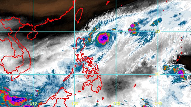
MANILA, Philippines – Rosal intensified from a tropical depression into a tropical storm, the weather bureau said on Sunday evening, December 11.
It has been given the international name Pakhar, a name contributed by Laos.
Rosal now has maximum sustained winds of 65 kilometers per hour from the previous 55 km/h, said the Philippine Atmospheric, Geophysical, and Astronomical Services Administration (PAGASA) in its 11 pm bulletin on Sunday. Its gustiness went up to 80 km/h from 70 km/h.
The tropical storm was already 570 kilometers east of Tuguegarao City, Cagayan, or 580 kilometers east of Aparri, Cagayan.
It is moving northeast, or away from Philippine landmass, at a slightly faster 20 km/h from the previous 15 km/h.
Rosal is seen to maintain a northeast or east northeast direction until Tuesday morning, December 13, before turning southeast.
It did not make landfall, though it did bring heavy rain and strong winds to parts of the country during the weekend. Signal No. 1 was lifted on Saturday evening, December 10.
PAGASA said late Sunday that Rosal’s trough or extension may still cause rain showers, possibly in the eastern part of Luzon, but conditions are improving as the tropical storm moves away.
The surge of the northeast monsoon or hanging amihan, partly enhanced by Rosal, also continues to bring occasional gusts to the following areas:
- Batanes
- Babuyan Islands
- northern and eastern parts of Cagayan
- eastern part of Isabela
- Ilocos Norte

Also due to the surge of the northeast monsoon, PAGASA renewed its gale warning at 5 pm on Sunday:
- seaboards of Northern Luzon (Batanes, Ilocos Norte, Ilocos Sur, La Union, Pangasinan, Cagayan including Babuyan Islands) – rough to very rough seas, waves 2.8 to 5 meters high
The weather bureau advised fishing boats and other small vessels not to sail, and larger vessels to watch out for big waves.
The surge of the northeast monsoon and the tropical storm combined may still cause moderate to rough seas, with waves 1.5 to 3.5 meters high, in the seaboards of Central Luzon as well as the eastern and western seaboards of Southern Luzon. Travel may be risky for small vessels.
PAGASA said Rosal may start weakening late Monday, December 12, due to “increasingly unfavorable conditions associated with the monsoon surge,” referring to cold air. Tropical cyclones are fueled by warm air.
It may become “a post-tropical low embedded along the leading edge of the monsoon surge” by late Tuesday or on Wednesday, December 14.
Rosal is the country’s 18th tropical cyclone for 2022 and the first for December. The weather bureau earlier said there may be one or two tropical cyclones during the month. – Rappler.com
Add a comment
How does this make you feel?


There are no comments yet. Add your comment to start the conversation.