SUMMARY
This is AI generated summarization, which may have errors. For context, always refer to the full article.
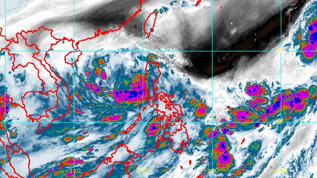
MANILA, Philippines – Typhoon Karding (Noru) exited landmass through the province of Zambales before dawn on Monday, September 26, after unleashing fierce winds and torrential rain in Central Luzon.
Karding first made landfall as a super typhoon in Burdeos, Quezon, at 5:30 pm on Sunday, September 25, followed by another landfall as a typhoon in Dingalan, Aurora, at 8:20 pm.
It then crossed Nueva Ecija, Tarlac, and Zambales.
By 4 am on Monday, Karding was already over the coastal waters of Santa Cruz, Zambales, the Philippine Atmospheric, Geophysical, and Astronomical Services Administration (PAGASA) said in its 5 am bulletin.
The typhoon was moving west northwest at 30 kilometers per hour, faster than its previous speed of 20 km/h. It will keep moving over the West Philippine Sea toward Vietnam, with its exit from the Philippine Area of Responsibility (PAR) expected on Monday evening.
Karding’s maximum sustained winds had gone down to 140 km/h, with gustiness of up to 170 km/h. At its peak, it had maximum sustained winds of 195 km/h.
Karding may re-intensify starting Monday evening or early Tuesday morning, September 27, while over the West Philippine Sea.
Rain from the typhoon is expected to persist until noon on Monday. PAGASA warned that there may still be scattered to widespread floods and landslides.
Heavy to intense rain, with at times torrential rain
- Zambales
- Bataan
- Tarlac
Moderate to heavy rain, with at times intense rain
- western part of Pangasinan
- Pampanga
- Cavite
- Lubang Islands
Light to moderate rain, with at times heavy rain
- Metro Manila
- rest of Pangasinan
- La Union
- Benguet
- Nueva Vizcaya
- Nueva Ecija
- Bulacan
- Rizal
- Laguna
- western part of Batangas
- western part of mainland Occidental Mindoro
The southwest monsoon or hanging habagat will also affect the western parts of Central Luzon; Southern Luzon, including Metro Manila; and the Visayas on Monday.
Meanwhile, Signal Nos. 1, 2, and 3 remain in effect, but PAGASA said “rapid de-escalation of wind signals remains likely as Karding moves further away from the landmass of Luzon.”
Signal No. 3
Storm-force winds (89 to 117 km/h), moderate to significant threat to life and property
- western part of Pangasinan (Bolinao, Bani, Anda, Alaminos City, Sual, Labrador, Bugallon, Aguilar, Mangatarem, Mabini, Infanta, Dasol, Burgos, Agno)
- northern and central parts of Zambales (Candelaria, Masinloc, Palauig, Iba, Botolan, Cabangan, San Felipe, San Narciso, Santa Cruz)
Signal No. 2
Gale-force winds (62 to 88 km/h), minor to moderate threat to life and property
- rest of Pangasinan
- La Union
- southern part of Benguet (Sablan, La Trinidad, Baguio City, Tuba, Itogon)
- Tarlac
- western part of Nueva Ecija (Lupao, Science City of Muñoz, Talavera, Santo Domingo, Aliaga, Jaen, Zaragoza, San Antonio, Cabiao, Licab, Quezon, Talugtug, Guimba, Cuyapo, Nampicuan)
- Pampanga
- rest of Zambales
- northern part of Bataan (Dinalupihan, Balanga City, Pilar, Abucay, Samal, Orani, Hermosa, Morong, Bagac)
Signal No. 1
Strong winds (39 to 61 km/h), minimal to minor threat to life and property
- Ilocos Sur
- rest of Benguet
- western part of Ifugao (Hungduan, Kiangan, Hingyon, Banaue, Lagawe, Lamut, Asipulo, Tinoc)
- western part of Mountain Province (Sagada, Besao, Tadian, Bauko, Sabangan, Bontoc)
- Quirino
- Nueva Vizcaya
- central and southern parts of Aurora (Dingalan, San Luis, Maria Aurora, Dipaculao, Baler)
- rest of Nueva Ecija
- Bulacan
- rest of Bataan
- Metro Manila
- extreme northern part of Quezon (General Nakar)
- Rizal
- western part of Laguna (Los Baños, Calamba City, Cabuyao City, Santa Rosa City, Biñan City, San Pedro City)
- western part of Batangas (Balayan, Calaca, Calatagan, San Luis, Mabini, Bauan, Alitagtag, Santa Teresita, Taal, Agoncillo, San Nicolas, Talisay, Cuenca, Mataasnakahoy, Tanauan City, Malvar, Santo Tomas, Balete, Lemery, Laurel, Tuy, Lian, Nasugbu)
- Cavite
- northern part of Occidental Mindoro (Paluan, Abra de Ilog) including Lubang Islands
PAGASA is no longer warning of storm surges, but it said that high waves breaking along the coast of Zambales, Bataan, and Pangasinan may cause floods in “exposed and low-lying coastal communities.”
A new gale warning was issued at 5 am on Monday, covering the western seaboards of Northern Luzon and Central Luzon, particularly Ilocos Sur, La Union, Pangasinan, Zambales, and Bataan. Seas are rough to very rough, with waves 2.8 to 4.5 meters high. PAGASA advised fishing boats not to sail and larger vessels to watch out for big waves.
The enhanced southwest monsoon may also cause moderate to rough seas in the western seaboards of Southern Luzon, the Visayas, and Mindanao. Waves could be 1.5 to 3 meters high, which may be risky for small vessels.

Karding is the Philippines’ 11th tropical cyclone for 2022.
It is also the third tropical cyclone for September, after Typhoon Inday (Muifa) and Super Typhoon Josie (Nanmadol). Inday and Josie did not make landfall in the country.
PAGASA expects 7 to 11 tropical cyclones to enter or develop inside PAR from September 2022 to February 2023. Per month, these are the weather bureau’s estimates:
- September 2022 – 2 or 3
- October 2022 – 2 to 4
- November 2022 – 2 or 3
- December 2022 – 1 or 2
- January 2023 – 0 or 1
- February 2023 – 0 or 1
– Rappler.com
Add a comment
How does this make you feel?


There are no comments yet. Add your comment to start the conversation.