SUMMARY
This is AI generated summarization, which may have errors. For context, always refer to the full article.
![[OPINION] Mount Natib and her sisters](https://www.rappler.com/tachyon/2021/03/mount-natib.jpg)
The following is the second in a series of excerpts from Kelvin Rodolfo’s ongoing book project “Tilting at the Monster of Morong: Forays Against the Bataan Nuclear Power Plant and Global Nuclear Energy.“
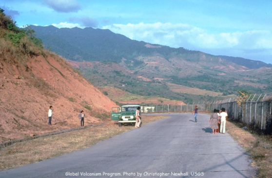
Mark Cojuangco may be very intelligent, but he certainly was geologically illiterate when he wrote the Explanatory Note for his House Bill HB4631. Knowing so little about volcanoes, he said Natib Volcano is “10 kilometers from the BNPP.”
A volcano is not just its vent. The BNPP sits on the western coast of Natib, a dormant volcano so massive that many people who frequently travel on its roads don’t even realize it is a volcano. Natib is the entire mass of northern Bataan. Its diameter above the ocean is 26 kilometers – 16 miles. Its slopes extend offshore 60 meters below sea level more than a kilometer off Napot Point. Natib is 4,111 feet high – about one and a quarter kilometer tall. When Natib last erupted is uncertain — no earlier than 18,000 years ago, and almost certainly more recently.
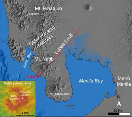
Natib lines up with two sister volcanos. To her south is Mt. Mariveles, which makes up all the rest of Bataan; to her north, separated from it by a jumble of older volcanic rocks, is Mt. Pinatubo, whose 1991 eruption was the world’s most powerful eruption of more than a hundred years.
All three sisters are “calderagenic.” This means that they rarely erupt, but when one does, the explosions are very violent. As the eruption subsides, rock collapsing into the space vacated by the magma makes many earthquakes, as Zambaleños and the people of Olongapo City well remember. The eruption leaves a large cavity called a caldera at the volcano summit. This is not to be confused with what is called a crater in a less violent volcano like Mayon. Craters are much smaller and form from small eruptions, and when lava stops flowing and subsides back down the volcano’s throat.
Note that the active Lubao Fault extends southwestward from the plains north of Manila Bay to cut through Natib and emerge at the BNPP. In a later foray, we will closely examine the Lubao Fault.
We are fortunate, in a way, that Pinatubo erupted in 1991, because it gives us hints of the widespread havoc and devastation that a Natib eruption could wreak. Memories of the darkness at noon, the heavy rain of tephra and ash, the constant roar, the jolting earthquakes without end in Zambales, and the ash falling on Manila 80 kilometers away, give flavor to the cold statistics: As much as three cubic kilometers of Pinatubo’s bulk was blown away. A caldera more than two kilometers wide was left by the explosions and the collapse of rock masses into the void. On its rim, Pinatubo’s new highest point is a half kilometer lower than the summit used to be.
The eruption left huge quantities of rock debris on the volcano slopes. During the eruption, and for years that followed, the torrential typhoon and habagat (southwest monsoon) rains whipped the debris into huge, devastating lahar flows like freshly mixed concrete, that buried entire villages around Pinatubo.
Mariveles also has a large caldera – larger, even, than Pinatubo’s – four kilometers across. If caldera size is any measure of eruption power, the one that produced it was stronger. We can’t really say; the eruption happened long ago, before human memory or folk tradition, more than 2,000 years ago.
Natib, the BNPP’s home, has two calderas!
Mt. Natib’s calderas
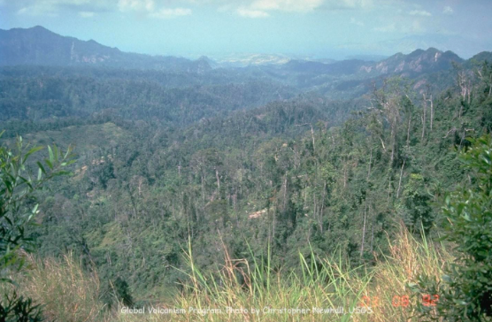
The large Natib Caldera dwarfs even Mariveles’. Elongated 7.5 kilometers from north to south and 5 kilometers from east to west, it is so large that this photo taken from its rim by the famous volcanologist Christopher Newhall can hardly take it all in and give a sense that it is indeed a caldera. Did a single eruption, more powerful than Pinatubo’s in 1991, form it? Or did it take more than one eruption? We can only speculate.
In the late 1980s, JR Ruaya and CC Panem of the Philippine National Oil Corporation evaluated the potential of Natib Caldera as a source of geothermal energy, an excellent piece of work. This map is my modification of their original:
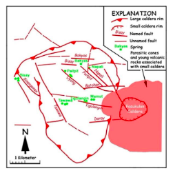
Natib’s smaller “Pasukulan” caldera is circular and two kilometers in diameter, about the same size as the one produced at the Pinatubo summit in 1991. Was it formed by eruption of similar magnitude? We know that it happened after Natib Caldera had formed because it disrupts its eastern rim, like how a later footprint in mud deforms an earlier one.
Natib Caldera has many faults, and hot springs come steaming out of them. The source of the heat underground is hotter than 200°C. This is much more activity than Pinatubo demonstrated in 1991 before its world-class eruption.
Are these merely the last gasps of a dying volcano? Or should we take them as signs of a volcano still capable of eruption? And which makes more sense: using some of this thermal energy to generate electricity, or activating the BNPP? A geothermal electric facility might eventually be destroyed by an eruption, but would release no dangerous radioactive debris.
Propaganda: Mark Conjuangco
If the BNPP is to be activated, the Filipino people must be convinced it is safe. Cojuangco’s collaborators in the media clearly know no more geology or nuclear technology than he does, and repeat many of his naive statements. Perhaps most distressing, government geologists who know, or should know better, also attest to its safety, such being the powerful influence of money.
In 2009, newspaper columnists and TV commentators propagated Cojuangco’s mistaken notion that the farthest a volcanic mass can travel is six times the elevation of the volcano. Geologists will recognize this as a misuse of a ratio that we use to estimate how far a landslide can travel. Landslides are minor, compared to other volcanic hazards.
In his Explanatory Note for HB 4631, Mark Cojuangco, wrote, “Top geologists have evaluated Bataan and, with the exception of Mt. Natib which is a dormant volcano whose last eruption was estimated to have been between 11.3 to 18 thousand years ago (Cabato et. al. 2005) and which is ten kilometers (10 km) from the BNPP, could find no anomalies in locating the plant there.”
For a scientist who studies natural hazards mainly to protect human life, nothing is more horrifying than for one’s research to be distorted and used to validate a dangerous enterprise. The “top geologists” Cojuangco referred to are Joan Cabato, who earned her MS degree with this study, and her “et al” collaborators and mentors were Fernando (“Ando”) Siringan, then a professor at the National Institute of Geological Sciences, and myself.
I will describe our work in detail later. First of all, though, I must say emphatically for the three of us that we had nothing to do with locating the BNPP on Natib, and never would have, as this and other forays should make abundantly clear.
But without realizing it, Cojuangco was bringing attention to the most dangerous hazard that confronts the BNPP. Our paper reported the deposit of a massive pyroclastic flow from Natib Volcano in Subic Bay. The eruption that formed Natib Caldera opened it to the west and sent its debris products that way down and into Subic Bay.
Our next foray will describe pyroclastic flows, BNPP’s worst hazard. – Rappler.com
Born in Manila and educated at UP Diliman and the University of Southern California, Dr. Kelvin Rodolfo taught geology and environmental science at the University of Illinois at Chicago since 1966. He specialized in Philippine natural hazards since the 1980s.
Keep posted on Rappler for the next installment of Rodolfo’s series.
Previous pieces from Tilting at the Monster of Morong:
Add a comment
How does this make you feel?


There are no comments yet. Add your comment to start the conversation.