SUMMARY
This is AI generated summarization, which may have errors. For context, always refer to the full article.
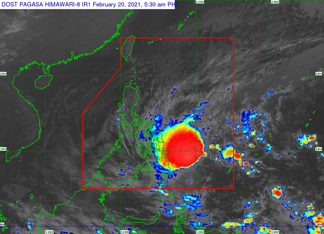
Tropical Storm Auring (Dujuan) slightly weakened over the Philippine Sea before dawn on Saturday, February 20, but heavy rain is still likely in areas in its path.
In a bulletin issued 5 am on Saturday, the Philippine Atmospheric, Geophysical, and Astronomical Services Administration (PAGASA) said Auring now has maximum sustained winds of 75 kilometers per hour (km/h) and gustiness of up to 90 km/h.
“Dulot po ‘yan ng epekto ng malakas na hangin na dulot ng amihan (This is because of the air brought by the northeast monsoon),” said PAGASA Weather Specialist Aldczar Aurelio in a briefing past 5 am.
The northeast monsoon or hanging amihan brings cold, dry air, while tropical cyclones gain strength from warm, moist air.
On Friday evening, February 19, Auring had maximum sustained winds of 85 km/h and gustiness of up to 105 km/h. It previously reached severe tropical storm category on Friday morning, then weakened back into a tropical storm in the afternoon. (READ: FAST FACTS: Tropical cyclones, rainfall advisories)
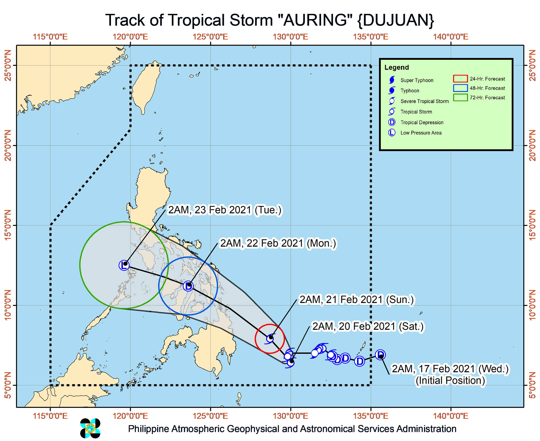
As of early Saturday, Auring was located 475 kilometers east southeast of Hinatuan, Surigao del Sur, still barely moving.
PAGASA said Auring is likely to “remain almost stationary in the next 6 to 12 hours before gradually accelerating towards the northwest.”
Its projected landfall is still Sunday morning or afternoon, February 21, in the eastern coast of the region of Caraga. Then it would cross the Visayas and Mimaropa for the rest of Sunday until Monday, February 22.
PAGASA said Auring is “more likely” to remain a tropical storm until it hits Caraga, though there is also an “increasing likelihood” that it may weaken into a tropical depression before making landfall.
Once it hits land, it is also seen to “weaken considerably due to significant terrain interaction and persistent vertical wind shear.” The World Meteorological Organization defines wind shear as “layers or columns of air, flowing with different velocities (i.e. speed and/or direction) to adjacent layers or columns.”
Despite Auring’s slight weakening, PAGASA warned that the tropical storm is still bringing rain. Floods and landslides could still occur.
Here is PAGASA’s latest rainfall forecast:
Until Saturday noon, February 20
Light to moderate rain, with at times heavy rain
- Eastern Visayas
- Caraga
- Davao Oriental
- Davao de Oro
- Davao del Norte
- Bukidnon
- Misamis Oriental
- Southern Leyte
Saturday noon, February 20, until Sunday morning, February 21
Heavy to intense rain
- Surigao del Norte
- Surigao del Sur
- Dinagat Islands
Moderate to heavy rain, with at times intense rain
- rest of Caraga
- Misamis Oriental
- Camiguin
Light to moderate rain, with at times heavy rain
- Eastern Visayas
- Central Visayas
- rest of Northern Mindanao
- Davao Oriental
- Davao de Oro
- Davao del Norte
Sunday morning, February 21, until Monday morning, February 22
Moderate to heavy rain, with at times intense rain
- Leyte
- Southern Leyte
- Cebu
- Bohol
- Surigao del Norte
- Dinagat Islands
Light to moderate rain, with at times heavy rain
- Bicol
- Mimaropa
- southern part of Quezon
- rest of Visayas
- rest of Caraga
- Zamboanga Peninsula
- Northern Mindanao
- Davao Oriental
- Davao de Oro
- Davao del Norte
Meanwhile, the areas below remain under Signal No. 1. Tropical cyclone wind signals refer to wind, not rainfall.
- Northern Samar
- Eastern Samar
- Samar
- Biliran
- Leyte
- Southern Leyte
- Cebu
- Negros Oriental
- Bohol
- Siquijor
- Dinagat Islands
- Surigao del Norte
- Surigao del Sur
- Agusan del Norte
- Agusan del Sur
- Davao Oriental
- Davao de Oro
- Davao del Norte
- Davao City
- Camiguin
- Misamis Oriental
- Misamis Occidental
- Lanao del Norte
- Bukidnon
- Lanao del Sur
PAGASA said Auring and the surge of the northeast monsoon combined will bring strong to gale-force winds to areas under Signal No. 1 in the next 24 hours.
Similar windy conditions will also be experienced in the rest of the Visayas, Bicol, and Calabarzon, as well as Occidental Mindoro, Oriental Mindoro, Marinduque, Romblon, and the northern part of Palawan, including Calamian, Cuyo, and Kalayaan Islands.
The state weather bureau added that strong breeze to near-gale conditions are likely in the rest of Luzon.
PAGASA maintained its forecast for coastal waters.
Rough to high seas
Travel is risky for all types of vessels
- seaboards of areas under Signal No. 1 (waves 2.8 to 7 meters high)
Rough to very rough seas
Travel is risky for all types of vessels
- eastern and southern seaboards of Southern Luzon, and remaining seaboards of Visayas (waves 2.8 to 5 meters high)
Rough seas
Travel is risky for all types of vessels
- northern and western seaboards of Mindanao, and remaining seaboards of Luzon (waves 2.5 to 4 meters high)
Moderate to rough seas
Small vessels must take precautionary measures, inexperienced mariners should avoid navigation
- rest of the seaboards of the Philippines (waves 1.2 to 3 meters high)
Auring is the Philippines’ first tropical cyclone for 2021.
An average of 20 tropical cyclones form within or enter the Philippine Area of Responsibility (PAR) each year. (READ: LIST: PAGASA’s names for tropical cyclones in 2021)
These are PAGASA’s latest estimates for the number of tropical cyclones inside PAR in the next 6 months:
- February – 0 or 1
- March – 0 or 1
- April – 0 or 1
- May – 0 or 1
- June – 1 or 2
- July – 2 or 3
PAGASA earlier said La Niña is expected to continue until March 2021, causing above normal rainfall in the country. The onset of La Niña was declared in October 2020. – Rappler.com
Add a comment
How does this make you feel?


There are no comments yet. Add your comment to start the conversation.