SUMMARY
This is AI generated summarization, which may have errors. For context, always refer to the full article.
MANILA, Philippines – So many people have died because government insists on using maps that rely on historical anecdotes about disasters, rather than scientific data that is able to predict with substantial accuracy where hazards lie.
Local governments should be using what is called “probabilistic maps” in hazard mapping if they want to reduce the number of casualties during disasters, geologist and disaster scientist Dr. Mahar Lagmay told Rappler in an interview last June.
Lagmay is also the director of NOAH [Nationwide Operational Assessment of Hazards] Center at the University of the Philippines which seeks to increase awareness about natural hazards to bring about a “culture of preparedness” and reduce the “catastrophic impacts of extreme hazard events.”
“We know the physics of the flow of water, there is a lot of understanding about it throughout the decades published by scientists and we use [that] knowledge to simulate with computers and validate the landslide maps that we produce. The accuracy is high, around 90%,” Lagmay said in a mix of English and Filipino.
Yet there have been several instances when people who were seeking refuge in evacuation centers ended up being killed.
He cited cases in Tacloban in 2013, Compostela Valley in 2012, and the Kusiong Relocation Site in Datu Odin Sinsuat, Maguindanao del Norte in 2022.
“Why do people frequently die in evacuation centers? In Tacloban, a lot of people who were in evacuation centers died during [Super Typhoon] Yolanda; in Barangay Andap, Compostela Valley, more than 500 people who fled to the evacuation center died in 2012. Then here in Kusiong, that happened as well,” Lagmay said.

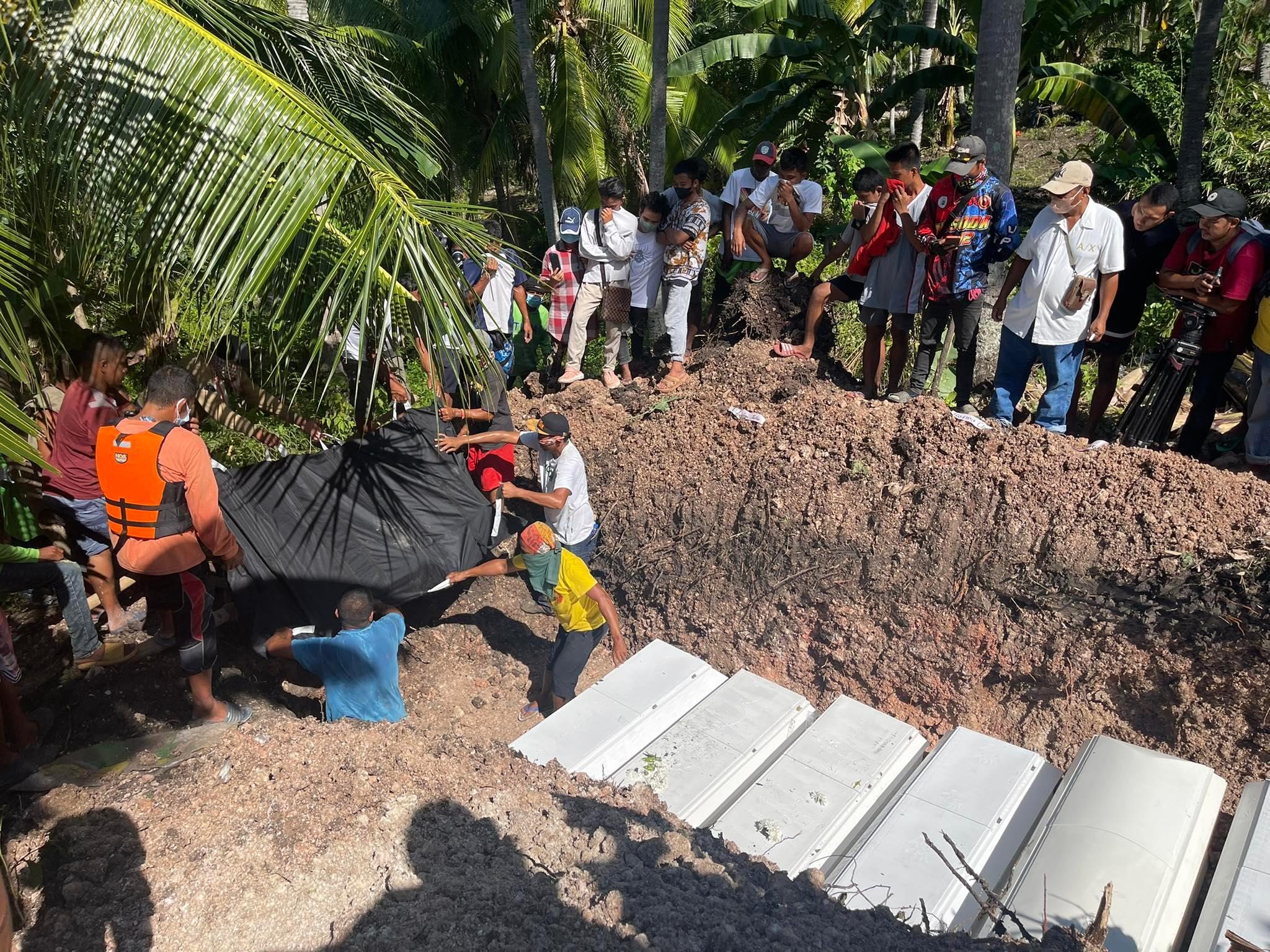
The Kusiong landslide claimed 65 lives and injured 18 more people. Afraid of possible flooding, Teduray residents of the Kusiong Relocation Site fled to a chapel on higher ground at midnight during the onslaught of Severe Tropical Storm Paeng.
During Typhoon Pablo‘s landfall in December 4, 2012, debris flow in the Mayo River watershed
swept large parts of Andap Village in New Bataan, Compostela Valley, burying areas
under rubble as thick as nine meters and killing 566 people.
One of the most powerful storms in history, Super Typhoon Yolanda (Haiyan) took the lives of more than 6,000 people, affected millions, and caused P95.48 billion in damage when it hit the country on November 8, 2013. A decade since it devastated the country, Tacloban, which bore the brunt and became ground zero of Yolanda, is still far from complete recovery. (READ: 10 years on, Yolanda survivors grapple with memory, delayed recovery)
‘Deterministic maps’
The problem, according to Lagmay, lies with where evacuation centers are located. These are often based on “deterministic maps” that rely on historical anecdotes from residents. Local accounts change only after a disaster happens.
“The way they prepare [this] is, they interview people living in an area, ‘Did a landslide ever occur here?’ It’s all visuals, subjective. And then they color the map,” Lagmay said, referring to the colors used to show the different risk levels of areas in hazard maps.
In contrast, probabilistic maps, which use multiple simulations to predict bigger hazards in an area, are able to warn people about places where infrastructure should not be built – even before a disaster strikes. They go beyond what people remember as having occurred in the past.
Lagmay said that NOAH Center uses probabilistic maps in its hazard mapping, unlike the government-run HazardHunterPH, which relies on deterministic maps.
Deadly planning
Past deaths in evacuation centers and resettlement areas that were destroyed in disasters could have been avoided had the government used NOAH’s probabilistic maps, Lagmay said.
“If only the government used the maps NOAH made, they’ll see the areas where people died are also where the buildings are, which are colored red. That’s where the people were buried during the landslide, but the local disaster risk reduction and management plan had a map that shows low landslide susceptibility for that area,” Lagmay said.
He was referring to the buildings located in Sitio Sindulan, Barangay Tinaan in Naga City, Cebu. On September 20, 2018, a massive landslide devastated the barangay, with most of the deaths recorded in Sitio Sindulan, claiming the lives of 78 villagers.
Government hazard maps identify Sitio Sindulan as “an area with low landslide susceptibility,” according to Lagmay and his team’s recently published research.
Maps need updating
Lagmay also said that despite the need to update and use probabilistic maps, government, to this day, still uses deterministic maps for planning.
“[The] maps that are produced are being used for planning of all of our communities – 1,700 cities and municipalities of the country. We’re still at the deterministic stage,” Lagmay said.
The disaster scientist cited United Nations Disaster Risk Reduction guidelines that say probabilistic maps are needed because probabilistic risk modeling “estimates risk in terms of people affected, loss and damages,” and provides possible outcomes for those estimates.
Lagmay also cited the Philippine Development Plan 2023-2028 which stipulates the use of probabilistic climate risk assessment by referring to the National Climate Management Risk Framework (NCRMF).
Under the NCRMF, the Climate Change Commission is supposed to adopt and promote activities connected to climate change, one of which is the use of probabilistic climate risk assessment.
“We need to plan for them and adapt to those future climate change impacts which may be happening now already,” Lagmay said. – Rappler.com
Add a comment
How does this make you feel?


There are no comments yet. Add your comment to start the conversation.