SUMMARY
This is AI generated summarization, which may have errors. For context, always refer to the full article.


First of 2 parts
Editor’s Note: At least 27 Tedurays died in the landslides at the foothills of Mt. Minandar, a resettlement area where locals were forced to relocate in 2020. This investigative series traces the environmental and political factors that created the disaster, and why the indigenous community remains homeless a year after the tragedy.
This reporting project was supported by the International Women’s Media Foundation’s Howard G. Buffett Fund for Women Journalists.
MAGUINDANAO DEL NORTE, Philippines – Kas* couldn’t sleep as the skies kept on crying.
“Sabi ni Papa: ‘Huwag ka mag-alala. Tubig lang ‘yan,’” he recalled. (My father said: “Don’t worry. It’s just water.”)
But by past 2 am on October 28, 2022, Kas heard unusual, whirring sounds. He immediately opened their door to check – only to witness rock boulders, tree logs, and decimated houses raging all over.
“Pagsara ko [ng pinto], paglingon ko kay Papa, wala na [siya],” he said. (When I closed the door and looked back at Papa, he was gone.)
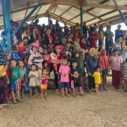
Kas survived the ambush of the landslides overnight after drifting in the wave-like floods and being buried alive in mud at the foothills of Mt. Minandar. But at least 27 Tedurays from their village did not, many of them babies and children.
This is a double tragedy for Kas and his community who say that the deaths would not have happened if they were not forced to vacate the seaside two years earlier – an area later established for businesses which remained unharmed during Severe Tropical Storm Paeng’s (Nalgae) landfall in late October 2022.
A year after the disaster, many survivors are still living in makeshift shelters. But along Kusiong’s shorelines – former home to the Tedurays – private resorts continue to operate. One of them is owned by a local official’s daughter.
Forced, unsafe relocation
Kusiong, an agricultural and coastal village, is two-faced: quiet, lazy, and slow on weekdays, but blaring and bustling with tourists on weekends.
Blessed with the beauty and bounty of the Moro Gulf, more than a dozen resorts dot the shorelines of Kusiong. It is located in Datu Odin Sinsuat (DOS) municipality in the Maguindanao del Norte province – about an hour’s ride away from Cotabato City, the seat of power of the Bangsamoro Autonomous Region in Muslim Mindanao (BARMM).
The rural community is home to the Maguindanaon Moros (Muslims) and the Teduray, non-Moro indigenous peoples who compose the majority of Kusiong’s population yet are considered the “minority of the minority” in a historically neglected region.
For decades, Tedurays have lived on the mountains and by the shores of Kusiong, working as farmers and fisherfolk. But this changed when some private resorts were recently established, displacing around 300 families, including Moros, from the coastlines of the village.
Pat* was among them. He lived in Kusiong for 28 years until an anonymous, handwritten letter found its way to his doorstep in October 2020.
He recounted how they were given only three months to vacate the shoreline, with the vague notion about a project that was going to be developed along the coast. They couldn’t find anyone to confirm who really owned the land.
There were just people from the mayor’s office who had IDs or who introduced themselves as employees, who would visit their area, and that was all.
The lack of genuine consultations with the community violated the indigenous peoples’ right to give their free and prior informed consent prior to the relocation, Pat said, despite their being supposedly protected under Philippine law.

The Tedurays traditionally occupied lands in Kusiong and other areas in the Maguindanao province even before there was a Philippine republic, but Spanish colonizers forced agricultural labor on their ancestors and formally titled tribal lands.
According to peacebuilding organization International Alert Philippines, majority of these land titles were eventually acquired by Maguindanaon Moros and Christian settlers, although it is unclear how they got hold of these documents.
Since 2005, the Tedurays have been fighting for their ancestral domain claim which is yet to be awarded until today.
Community sources also said that while there were no police or military personnel surrounding their area at the time, political henchmen who were present forced them to evacuate.
In a rush to transfer to the foothills of Mt. Minandar starting December 2020, the Tedurays unintentionally neglected performing their tribe’s customary protocols.
The Tedurays believe that villages must not be established at the foot of the mountain because it is a possible passageway of the mëginalëw (spirits) from the supernatural world to the earth, and vice versa. If unavoidable, rituals must be performed out of respect before occupation.
From the IP perspective, the tragedy happened because the spirits were angered by the houses and the peoples’ noises that disturbed them, explained the Timuay Justice and Governance, a traditional leadership and political structure of the Teduray and Lambangian tribe.
Apart from these, there was no relocation permit from the BARMM Ministry of Environment, Natural Resources, and Energy (MENRE) nor was the relocation included in the local comprehensive land use plan, lawyer Naguib Sinarimbo, head of the Ministry of Interior and Local Government, confirmed.
In a written response to Rappler, MENRE said, “It is the responsibility of the proponent to secure and request the needed certifications. No such application was submitted to MENRE and thus, we were not included in any process/dialogue concerning the resettlement.”
Each household, some of them having more than two families, received around P3,000 to P5,000 (US$53 to $88) as compensation for the house and the relocation, community sources disclosed. Pat alleged, however, that this wasn’t formal resettlement support since the cash was given as ayuda (aid), together with rice and canned goods, at the height of the COVID-19 pandemic.
Pat refused to accept the dole out. But Kas, like many others in the community, had no choice.
Life and loss at Mt. Minandar
Without any other government support, the locals relocated together, bayanihan style – from carrying nipa houses on foot to rebuilding their shelters at the bare foothills of Mt. Minandar, Kas recalled.
The residents gradually established their new houses out of their own pockets. This, amid intense hunger due to the sudden loss of jobs and the illnesses spawned by the use of mere tarpaulins or trapal for their shelters at the time.
“Nagbagong taon kami [na] sira ang bahay [namin],” Kas said. “Wala ka pang ilaw.” (We spent the New Year with a damaged house. We didn’t even have light.)
Almost two years since their relocation, Kas lost not only his job, but also his family to Mt. Minandar’s landslides. Triggered by heavy rainfall during Severe Tropical Storm Paeng, these landslides also devastated at least 100 houses and injured 65 people on October 28, 2022, according to an official MENRE report.

Many of those who died were children: There were 11 young Tedurays as small as a three-month-old baby to a kid who just reached first grade. The 15 others were equally budding adults, middle-aged persons, and seniors, while one person’s age remains unknown based on sourced documents.
These 27 deaths make up almost half of the overall number of fatalities in BARMM after Paeng, making Kusiong ground zero.
Echoing a common regret and sentiment of the community, Pat said none of them would have died if they weren’t displaced from the shoreline.
“Sa gano’ng tanong, meron bang dapat sisihin? Sa gano’ng sitwasyon, meron bang mana[na]got? Meron bang hustisya?,” he asked. (Is someone to blame? Will someone take responsibility for what happened? Will there be justice for us?)
Converting shorelines into private resorts
Since the forced relocation, three private resorts have been developed in the contested area.
Sources from the ground sent Rappler images of heavy-duty equipment that were the property of the Maguindanao province. These were present during the displacement in Kusiong in late 2020.
If this were a private project, government equipment should not have been used, Pat pointed out. “What would be used for gas? What would be used to load oil? Of course, provincial funds. Then there would also have to be people hired to do the work,” he said in Filipino.
Fearing violent dispersals and forced house demolitions, the people abandoned their place. Then bulldozers came to clear the shorelines. Old trees were cut. A Teduray ancestral burial site was even desecrated.
Where most of the Teduray community used to live now stands the Cheryl By The Sea Resort. Registered in January 2022, the business is owned by Bai Farisha Lu Sinsuat, records from the Department of Trade and Industry show.
Bai Farisha is a member of one of the most deeply entrenched political dynasties in the Philippines. She is the daughter of current DOS Vice Mayor Datu Sajid Sinsuat and Bai Cheryl Sinsuat, the municipality’s acting mayor at the time of the forced relocation.
Datu Sajid is also the brother of incumbent DOS Mayor Datu Lester Sinsuat, then-vice governor of the Maguindanao province, when government-owned equipment was allegedly used to develop the private resorts.
Community sources also said two other establishments were built in place of their former homes: The Pogi Sa Dilim Beach Resort and the Ahayahay Beach Resort, which officially began operations in December 2021 and April 2023, respectively. Disaster response documents obtained by Rappler and an online interview revealed that these resorts’ registered owners, Normina A. Balabaran and Babydhats L. Balabaran, were evacuees in Paeng’s aftermath.
According to MENRE, no foreshore lease agreements (FLA) were issued to these three private resorts. Nor did they submit applications to the agency. A FLA is required for commercial or industrial use of foreshore lands, marshy lands and any other lands that border bodies of water.
Rappler has repeatedly reached out to the Sinsuats and the registered resort owners this October through e-mails, Facebook, texts, and calls for their comment on the issues. We have yet to receive a response and will update this story when we do.
Underestimating hazards

Beyond the issues of forced relocation and the establishment of private resorts, the Kusiong tragedy also emerged from the government’s weak disaster preparations.
Long before beach resorts dominated the village, a nine-meter-high tsunami submerged people living along Kusiong’s coast right after an earthquake struck the province past midnight of August 17, 1976. The tragedy, known as the 1976 Moro Gulf Quake, killed around 8,000 people across Mindanao.
Due to the community’s collective trauma of this event that has been passed on from generation to generation and to avoid history repeating itself, local officials have regularly engaged residents only in earthquake and tsunami drills.
But dependence on memory and experience alone proved futile when Paeng struck in late October 2022. About 100 residents sought refuge at a nearby chapel located on higher ground at the foothills of Mt. Minandar. During the onslaught of the landslides, the chapel was crushed and buried, along with sanctuary-seeking residents.
An informed source who participated in Kusiong’s disaster planning disclosed that community leaders and village officials also conducted a hazard mapping activity in July 2022 – just three months before Paeng unleashed its fury.
No government hazard maps were provided in aid of the planning, the source confirmed. Residents themselves had to identify the hazards when landslides weren’t viewed as high risk at that point, while tsunamis and earthquakes were prioritized, internal documents shared with Rappler showed.
“Our hazard maps in the Philippines are prepared only based on the memory of disasters,” disaster scientist Mahar Lagmay said in Filipino, explaining the deterministic mapping method.
“If we prepare solely based on historical record, we will underestimate the impact of hazards,” he added. This is what happened to Kusiong, as well as communities in New Bataan, Compostela Valley, during Typhoon Pablo (Bopha) in 2012 and in Tacloban, Leyte, during Super Typhoon Yolanda (Haiyan) in 2013. In these incidents, people died after being relocated to unsafe resettlement areas, according to a recently published research on Philippine disasters.
Rappler also checked Kusiong’s ground zero using HazardHunterPH – an online tool powered by government-led GeoRisk Philippines to assess and inform the public about geohazards in a specific area – and it still tags the location as having low susceptibility to rain-induced landslides even after the Mt. Minandar tragedy. This plotting is similar to a 2022 MENRE hazard map of the site.
The University of the Philippines Resilience Institute’s Nationwide Operational Assessment of Hazards (NOAH) map of the location, however, shows the opposite.
Lagmay, who heads NOAH, explained that they use the Probabilistic Risk Assessment (PRA) approach to hazard mapping, which reflects multiple scenarios for a particular hazard, including the potentially worse that could happen due to climate change.
Had the NOAH hazard map been used for Kusiong’s disaster planning, the deaths and devastation could have been avoided, Lagmay concluded.
The PRA method has already been recommended by the United Nations Office for Disaster Risk Reduction and the Philippine government through its 2017-2022 and 2023-2028 Philippine Development Plans, and the 2019 Climate Change Commission resolution, yet it is not being implemented nationwide until today, according to the study.
As the Philippines remains one of the most vulnerable countries to the worsening impacts of climate change globally, approximately 1,700 cities and municipalities nationwide are still given the deterministic hazard maps for communities and local governments to use when planning against disasters.
“The business of hazard mapping is not to identify the hazard but really to identify the places where people can settle safely and develop safely,” Lagmay emphasized, advocating for the need to prioritize probabilistic hazard assessments.
“So even if landslides and floods occur, people are out of harm’s way. There won’t be a disaster,” he said in Filipino.
In July 2023, around nine months after the tragedy, the local government turned over 25 housing units to some surviving families, a source who did post-disaster assessments in Kusiong said.
But people have not transferred to the new shelters even a month after the turnover due to their substandard quality and flood-prone location just a few meters away from a rough, wide trail that has become a water passageway in Paeng’s aftermath.
“Bahay naman ng baboy ‘yan (housing unit),“ Kas said with a soft, resigned chuckle. “Sinubukan ko matulog du’n [sa loob]. Sakto lang tangkad ko.” (That’s like a pig’s house. I tried sleeping inside the unit. It’s too small.)
In Kusiong, no Teduray is above six feet tall. Kas is no exception.
Now, when the rain pours or the wind howls, when the waves crash violently, the displaced residents can’t sleep. Survivors breathe heavily in silent waiting, wondering if and when they’ll have to leave again the lands their ancestors toiled, lived, and died on.
Because on paper, Tedurays still cannot call Kusiong their home. (To be concluded) – Rappler.com
THE RAPPLER INVESTIGATIVE TEAM
This investigative report was produced by Raizza P. Bello, Laurice Angeles, Chay F. Hofileña, Jee Geronimo, Herbie Gomez, Emil Mercado, DR Castuciano, and Marian Hukom.
*The real names of several sources have been purposely changed and undisclosed for their own safety and protection.
NEXT: When fighting for ancestral lands hits a dead end
Do you have additional tips on Kusiong or concerns about instances of abuse, wrongdoing, or corruption in your community? Let us know and let’s chat. E-mail our team at investigative@rappler.com.
2 comments
How does this make you feel?


![[WATCH] #TheLeaderIWant: Filipino voters sound off on community issues a year before 2025 elections](https://www.rappler.com/tachyon/2024/05/filipino-voters-sound-off-on-community-issues-1.jpg?resize=257%2C257&crop=276px%2C0px%2C720px%2C720px)


First of all, thanks to Rappler’s investigative journalism and a new way of feature writing (reinforced with computer graphics). Secondly, based on this scenario, it can be induced that the Local Government Units involved gave greater priority to the welfare of the Political Dynasties that are in power rather than the affected communities. It is a grim reality of our society that we have to accept because beneficial change for marginal communities is hard to expect.
Thank you for reading this important story. In faraway Mindanao, it becomes increasingly harder for the marginalized to get their voices heard. We hope that legislators and policymakers will take notice.