SUMMARY
This is AI generated summarization, which may have errors. For context, always refer to the full article.
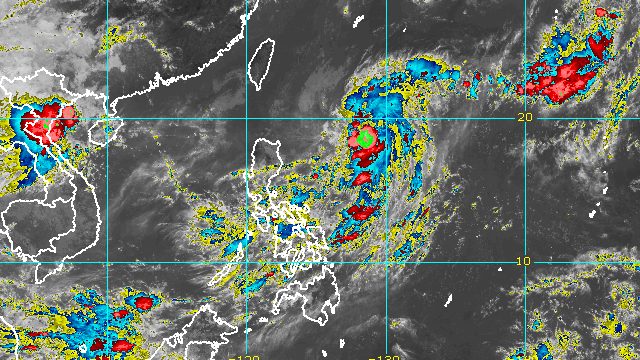
MANILA, Philippines – Inday (Muifa) intensified from a tropical storm into a severe tropical storm at 8 am on Friday, September 9, as it accelerated over the Philippine Sea.
Inday now has maximum sustained winds of 95 kilometers per hour from the previous 85 km/h, the Philippine Atmospheric, Geophysical, and Astronomical Services Administration (PAGASA) said in its 11 am bulletin on Friday. Its gustiness increased to 115 km/h from 105 km/h.
The severe tropical storm was last spotted 800 kilometers east of Aparri, Cagayan, heading northwest at 20 km/h after its slow pace earlier.
PAGASA said Inday remains “less likely” to bring heavy rain to the country and tropical cyclone wind signals will probably not be raised. It is not expected to make landfall.
But the trough or extension of the severe tropical storm is causing scattered rain showers and thunderstorms. The weather bureau earlier said the following areas would be affected on Friday:
- Bicol
- Panay Island (Aklan, Antique, Capiz, Iloilo)
- Eastern Samar
- Northern Samar
- Samar
- Quezon
- Occidental Mindoro
- Oriental Mindoro
- Marinduque
- Romblon
Inday may also trigger moderate to rough seas in Batanes (waves 2 to 4 meters high) and Babuyan Islands (waves 1.5 to 3 meters high) starting mid- to late Saturday, September 10. Conditions may be risky for small vessels.
The severe tropical storm is expected to maintain its northwest direction over the Philippine Sea until Sunday, September 11, before shifting north northwest or north over the sea east of Taiwan as it slows down.
PAGASA also sees Inday strengthening further until Sunday or early Monday, September 12, over the Philippine Sea, where it could become a typhoon by Saturday morning.
“However, the slightly cooler waters east of Taiwan and the forecast slowdown period over this sea area may result in a weakening trend beginning on Monday,” added the weather bureau.
Based on its latest forecast track, Inday may exit the Philippine Area of Responsibility (PAR) on Tuesday, September 13.

Inday is the Philippines’ ninth tropical cyclone for 2022 and the first for September.
PAGASA expects 7 to 11 tropical cyclones to enter or develop inside PAR from September 2022 to February 2023. Per month, these are the weather bureau’s estimates:
- September 2022 – 2 or 3
- October 2022 – 2 to 4
- November 2022 – 2 or 3
- December 2022 – 1 or 2
- January 2023 – 0 or 1
- February 2023 – 0 or 1
– Rappler.com
Add a comment
How does this make you feel?


There are no comments yet. Add your comment to start the conversation.