SUMMARY
This is AI generated summarization, which may have errors. For context, always refer to the full article.
Severe Tropical Storm Jolina (Conson) made its eighth landfall in San Juan, Batangas, at 9 am on Wednesday, September 8.
Typhoon Kiko (Chanthu), meanwhile, slightly intensified over the Philippine Sea.
Jolina
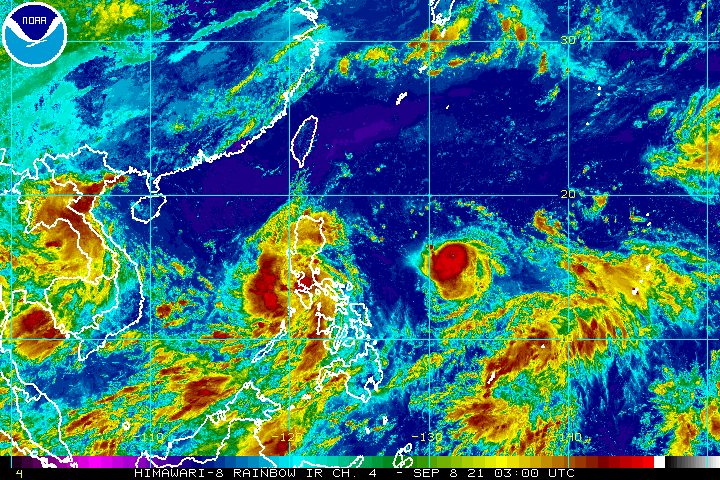
Jolina was last spotted in the vicinity of Rosario, Batangas, said the Philippine Atmospheric, Geophysical, and Astronomical Services Administration (PAGASA) in a bulletin released past 11 am on Wednesday.
The severe tropical storm slowed down, now moving northwest at only 10 kilometers per hour from the previous 15 km/h.
It continues to have maximum sustained winds of 95 km/h, while its gustiness is up to 130 km/h.
Rain from Jolina will persist on Wednesday, so residents must stay on alert for scattered to widespread floods and landslides. PAGASA has also added areas in Northern Luzon to its rainfall forecast as of 11 am.
Heavy to intense rain, with at times torrential rain
- Metro Manila
- Bataan
- Marinduque
- Cavite
- Laguna
- Batangas
- Rizal
- Quezon
- Occidental Mindoro
- Oriental Mindoro
Moderate to heavy rain, with at times intense rain
- Aurora
- Bulacan
- Nueva Ecija
- Pampanga
- Tarlac
- Zambales
- Camarines Sur
- Camarines Norte
- Romblon
- Marinduque
- northern part of Palawan including Calamian and Cuyo Islands
- Aklan
- Antique
- Capiz
- Iloilo
- Guimaras
- Negros Occidental
Light to moderate rain, with at times heavy rain
- Ilocos Region
- Cordillera Administrative Region
- Cagayan Valley
Many areas in Luzon remain under Signal Nos. 1 and 2. (READ: Why is it now called tropical cyclone ‘wind’ – and not ‘warning’ – signals?)
Signal No. 2 (damaging gale-force to storm-force winds)
- Marinduque
- northern and central parts of Oriental Mindoro (Bansud, Gloria, Pinamalayan, Pola, Socorro, Victoria, Puerto Galera, San Teodoro, Baco, Calapan City, Naujan)
- northern and central parts of Occidental Mindoro (Abra de Ilog, Paluan, Mamburao, Santa Cruz, Sablayan) including Lubang Islands
- central and southern parts of Quezon (General Luna, Macalelon, Sampaloc, Unisan, Pagbilao, Sariaya, Alabat, Pitogo, Tayabas City, Padre Burgos, Lucban, Gumaca, Agdangan, Plaridel, San Antonio, Candelaria, Atimonan, Quezon, Tiaong, Mauban, Perez, Lucena City, Dolores, Real, Infanta)
- Batangas
- Cavite
- Laguna
- Rizal
- Metro Manila
- southern part of Bulacan (Pandi, Bulacan, Marilao, Calumpit, Norzagaray, Plaridel, Santa Maria, Balagtas, Bocaue, Bustos, Malolos City, Angat, Obando, San Jose del Monte City, Pulilan, Meycauayan City, Hagonoy, Paombong, Guiguinto, San Rafael, Baliuag)
- Pampanga
- Bataan
- Zambales
- Tarlac
Signal No. 1 (strong winds with occasional gusts)
- La Union
- southern part of Benguet (Sablan, Tublay, Bokod, La Trinidad, Baguio City, Itogon, Tuba, Kapangan, Atok)
- southern part of Nueva Vizcaya (Alfonso Castañeda, Dupax del Norte, Dupax del Sur, Aritao, Santa Fe, Kayapa)
- southern part of Aurora (Baler, Maria Aurora, San Luis, Dingalan)
- Pangasinan
- Nueva Ecija
- rest of Bulacan
- rest of Quezon including Polillo Islands
- Camarines Norte
- western part of Camarines Sur (Ragay, Del Gallego, Lupi, Sipocot, Cabusao, Libmanan, Pasacao, Pamplona)
- western part of Romblon (Odiongan, Romblon, Banton, Santa Maria, Concepcion, San Andres, San Jose, Looc, Ferrol, Alcantara, San Agustin, Calatrava, Corcuera, Santa Fe)
- rest of Oriental Mindoro
- rest of Occidental Mindoro
PAGASA again warned that storm surges up to 1 meter high could hit coastal areas of the following provinces in the next 24 hours:
- Oriental Mindoro
- Batangas
- Quezon
Storm surges may threaten life and property, warned the state weather bureau.
“In addition, coastal areas of localities under [tropical cyclone wind signals], especially those at No. 2, may also experience coastal flooding due to hazardous surf conditions,” PAGASA said.
Sea travel remains prohibited in areas affected by Jolina.
Rough to very rough seas (waves 2.5 to 5.5 meters high)
Travel risky for all vessels, inexperienced mariners should seek safe harbor
- seaboards of areas under Signal No. 2
Moderate to rough seas (waves 1.2 to 2.8 meters high)
Small vessels must take precautionary measures, inexperienced mariners should avoid navigation
- seaboards of areas under Signal No. 1
- remaining seaboards of Southern Luzon and Visayas
After its landfall in San Juan, Batangas, Jolina began to cross the rest of the province.
Following Batangas, the neighboring province of Cavite is Jolina’s next stop. The severe tropical storm is expected to emerge over Manila Bay on Wednesday afternoon or evening.
Then Jolina is seen to make its ninth landfall in Bataan. And, as it crosses mainland Luzon, it may weaken into a tropical storm.
So far, Jolina’s landfalls have been in these areas:
Monday, September 6 (as a typhoon)
- Hernani, Eastern Samar – 10 pm
Tuesday, September 7 (as a typhoon)
- Daram, Samar – 2 am
- Santo Niño, Samar – 3:40 am
- Almagro, Samar – 6:30 am
- Tagapul-an, Samar – 7:50 am
- Dimasalang, Masbate – 10 am
Wednesday, September 8 (as a severe tropical storm)
- Torrijos, Marinduque – 12:50 am
- San Juan, Batangas – 9 am
Finally, Jolina could emerge over the West Philippine Sea on Wednesday evening or early Thursday morning, September 9. It may regain strength beginning Thursday afternoon as it heads for the southern China-northern Vietnam area.
It is likely to leave the Philippine Area of Responsibility (PAR) on Thursday evening or early Friday morning, September 10.
Kiko
Meanwhile, Kiko was located 1,120 kilometers east of Central Luzon late Wednesday morning.
The typhoon was moving west southwest at the same speed of 20 km/h. It is expected to maintain that direction for the rest of Wednesday, before turning west northwest until Friday toward extreme Northern Luzon.
At the moment, Kiko has maximum sustained winds of 155 km/h from the previous 150 km/h and gustiness of up to 190 km/h from the previous 185 km/h.
But PAGASA expects the typhoon to keep gaining strength until Saturday, September 11, when it may reach its peak intensity of 185 to 205 km/h.
PAGASA said heavy rain from the typhoon could begin affecting the eastern part of Northern Luzon on Friday.
Tropical cyclone wind signals may also be raised for several provinces in Northern Luzon beginning Wednesday evening or Thursday morning. Signal No. 4 would be the highest possible tropical cyclone wind signal due to Kiko.
PAGASA added that Kiko may trigger rough conditions in the northern and eastern seaboards of Luzon beginning Thursday as it approaches Northern Luzon.
“Due to the strength of this tropical cyclone, sea condition over the waters in the northern provinces of the country will likely be risky for all types of seacraft in the coming days,” the state weather bureau said.
On Saturday, Kiko could pass near the southern coast of Taiwan, which is still within PAR. It may leave PAR that same day.
Weakening is possible on Sunday, September 12, as the typhoon interacts with Taiwan’s rugged terrain.
By Sunday evening or Monday morning, September 13, Kiko might make landfall in the southeastern part of China.
Jolina and Kiko are the Philippines’ 10th and 11th tropical cyclones for 2021.
An average of 20 tropical cyclones form within or enter PAR each year. (READ: LIST: PAGASA’s names for tropical cyclones in 2021)

For the next six months, these are PAGASA’s estimates for the number of tropical cyclones inside PAR:
2021
- September – 2 or 3
- October – 2 or 3
- November – 2 or 3
- December – 1 or 2
2022
- January – 0 or 1
- February – 0 or 1
– Rappler.com
Add a comment
How does this make you feel?


There are no comments yet. Add your comment to start the conversation.