SUMMARY
This is AI generated summarization, which may have errors. For context, always refer to the full article.
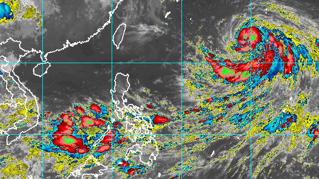
MANILA, Philippines – Nanmadol, the tropical cyclone outside the Philippine Area of Responsibility (PAR), intensified from a tropical storm into a severe tropical storm at 2 am on Thursday, September 15.
Severe Tropical Storm Nanmadol has maximum sustained winds of 95 kilometers per hour and gustiness of up to 115 km/h, the Philippine Atmospheric, Geophysical, and Astronomical Services Administration (PAGASA) said in its 5 am bulletin on Thursday.
“Present forecast scenario shows that this tropical cyclone will reach typhoon category within 24 hours,” added PAGASA.
Nanmadol was last spotted 1,830 kilometers east northeast of extreme Northern Luzon, moving west northwest at 15 km/h.
It is expected to gradually accelerate west northwest from Thursday to Friday, September 16, then turn more northwest on Saturday, September 17.
Based on that track, Nanmadol may enter PAR as a typhoon on Thursday evening or Friday morning. Its local name would be Josie.
PAGASA said Nanmadol or the potential Josie remains likely to stay far from Philippine landmass. It will not directly affect weather in the country.
But it could enhance the southwest monsoon or hanging habagat. Monsoon rain is possible in the western parts of Southern Luzon, the Visayas, and Mindanao on Thursday, particularly in the following areas:
- Zambales
- Bataan
- Occidental Mindoro
- Palawan
- Aklan
- Antique
- Negros Occidental
- Zamboanga Peninsula
- Basilan
- Sulu
- Tawi-Tawi
Flash floods and landslides are possible during periods of moderate to heavy rain.
The weather bureau also said gusty conditions may be felt in these areas due to the southwest monsoon:
- Mimaropa
- Bicol
- Visayas
- northern and western parts of Mindanao

Nanmadol or the potential Josie would be the Philippines’ 10th tropical cyclone for 2022.
It would also be the second tropical cyclone for September, after Typhoon Inday (Muifa), which did not make landfall.
PAGASA expects 7 to 11 tropical cyclones to enter or develop inside PAR from September 2022 to February 2023. Per month, these are the weather bureau’s estimates:
- September 2022 – 2 or 3
- October 2022 – 2 to 4
- November 2022 – 2 or 3
- December 2022 – 1 or 2
- January 2023 – 0 or 1
- February 2023 – 0 or 1
– Rappler.com
Add a comment
How does this make you feel?


There are no comments yet. Add your comment to start the conversation.