SUMMARY
This is AI generated summarization, which may have errors. For context, always refer to the full article.
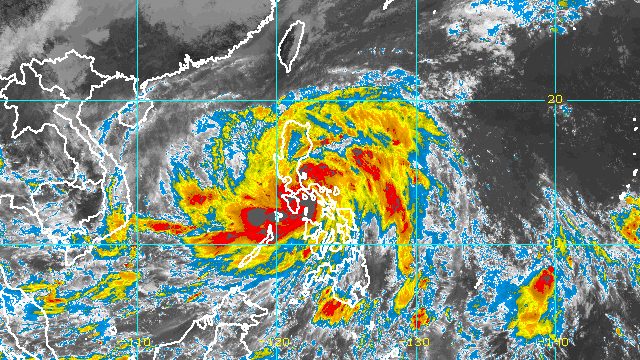
MANILA, Philippines – Severe Tropical Storm Paeng (Nalgae) made its fourth landfall in Santa Cruz, Marinduque, at 8:40 am on Saturday, October 29.
Its first three landfalls were also on Saturday, in the following areas:
- Virac, Catanduanes – 1:10 am
- Caramoan, Camarines Sur – 1:40 am
- Buenavista, Quezon – 6 am
By 10 am on Saturday, Paeng was already in the vicinity of Santa Cruz’s neighboring municipality, Mogpog.
The Philippine Atmospheric, Geophysical, and Astronomical Services Administration (PAGASA) said in a briefing past 11 am that the severe tropical storm is now moving west southwest at 25 kilometers per hour, slightly slower than the previous 30 km/h.
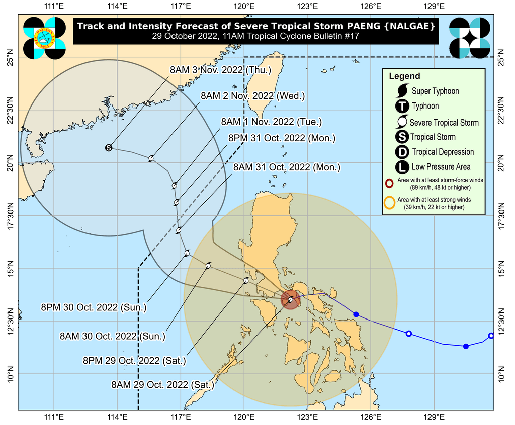
Based on Paeng’s latest forecast track, it could make its fifth landfall in the southeastern part of Batangas before crossing the Cavite-Metro Manila-Bataan area for the rest of Saturday.
A southward shift in its track, however, remains possible.
Paeng still had maximum sustained winds of 95 km/h late Saturday morning, with gustiness of up to 130 km/h.
It may weaken into a tropical storm while moving over land, then re-intensify into a severe tropical storm once it reaches the West Philippine Sea.
PAGASA updated its rainfall forecast for Paeng as of 11 am on Saturday, while reiterating that widespread floods and landslides are expected.
Saturday, October 29
Heavy to intense rain, with at times torrential rain
- Metro Manila
- Calabarzon
- Bicol
- Marinduque
- Romblon
- Occidental Mindoro
- Oriental Mindoro
- northern part of Palawan including Calamian and Cuyo Islands
Moderate to heavy rain, with at times intense rain
- mainland Cagayan Valley
- Cordillera Administrative Region
- Central Luzon
- Western Visayas
Light to moderate rain, with at times heavy rain
- rest of Luzon
- rest of Visayas
Sunday, October 30
Moderate to heavy rain, with at times intense rain
- Zambales
- Bataan
- Ilocos Region
Light to moderate rain, with at times heavy rain
- Metro Manila
- Mimaropa
- Calabarzon
- rest of Central Luzon
There are changes as well in the list of areas under tropical cyclone wind signals.
Signal No. 3
Storm-force winds (89 to 117 km/h), moderate to significant threat to life and property
- Marinduque
- northern and central parts of Quezon (Pitogo, San Andres, Buenavista, Lucena City, San Francisco, Pagbilao, Infanta, Tiaong, Lopez, Catanauan, Mulanay, Unisan, General Luna, Plaridel, Quezon, San Antonio, Alabat, Candelaria, Lucban, Sampaloc, Padre Burgos, Sariaya, Tayabas City, Macalelon, Mauban, Dolores, General Nakar, Perez, Agdangan, Gumaca, Atimonan, Real, San Narciso, Guinayangan, Calauag) including Polillo Islands
- Laguna
- Batangas
- Cavite
- Metro Manila
- Rizal
- Bataan
- southern part of Zambales (Olongapo City, Subic, Castillejos, San Antonio)
- Lubang Islands
Signal No. 2
Gale-force winds (62 to 88 km/h), minor to moderate threat to life and property
- northwestern part of Sorsogon (Pilar, Donsol)
- western part of Masbate (Aroroy, Baleno, Mandaon) including Burias Island
- Camarines Sur
- Camarines Norte
- Oriental Mindoro
- Occidental Mindoro
- rest of Quezon
- Romblon
- Nueva Ecija
- Pangasinan
- Albay
- southern part of Aurora (San Luis, Baler, Dingalan, Maria Aurora)
- Bulacan
- Pampanga
- Tarlac
- rest of Zambales
- northwestern part of Antique (Libertad, Pandan, Caluya Islands)
- western part of Aklan (Buruanga, Malay, Nabas, Ibajay, Tangalan, Makato, Numancia, Lezo)
Signal No. 1
Strong winds (39 to 61 km/h), minimal to minor threat to life and property
- Isabela
- Nueva Vizcaya
- Quirino
- Abra
- Kalinga
- Ifugao
- Mountain Province
- Benguet
- Ilocos Sur
- La Union
- rest of Aurora
- Catanduanes
- rest of Sorsogon
- rest of Masbate including Ticao Island
- northern part of Palawan (El Nido, Taytay, Dumaran, Araceli, Roxas, San Vicente) including Calamian and Cuyo Islands
- Northern Samar
- Samar
- Eastern Samar
- Biliran
- Leyte
- Southern Leyte
- Cebu including Bantayan and Camotes Islands
- Bohol
- Negros Occidental
- Negros Oriental
- Guimaras
- rest of Aklan
- rest of Antique
- Capiz
- Iloilo
Meanwhile, the surge of the northeast monsoon or hanging amihan enhanced by Paeng is bringing strong winds to these areas:
- Batanes
- Babuyan Islands
- northern and eastern parts of mainland Cagayan
- Ilocos Norte
- northern part of Apayao
PAGASA also warned that there is a minimal to moderate risk of storm surges up to 2 meters high, which may cause floods in the “low-lying and exposed coastal areas” of the following:
- western part of Pangasinan
- Zambales
- Bataan
- southern part of Aurora
- Quezon including Polillo Islands
- Bulacan
- Metro Manila
- Cavite
- Batangas
- Marinduque
- Camarines Norte
- Camarines Sur
- Albay
The gale warning issued at 5 am on Saturday remains in effect as Paeng and the northeast monsoon affect the country’s coastal waters.
- seaboards of Central Luzon and Southern Luzon and eastern seaboard of Visayas (Aurora, Zambales, Bataan, Pampanga, Bulacan, Metro Manila, Cavite, Batangas, Quezon including Polillo Islands, Occidental Mindoro including Lubang Islands, Oriental Mindoro, Marinduque, Romblon, Camarines Norte, Camarines Sur, Catanduanes, Albay, Sorsogon, Masbate including Burias Island and Ticao Island, Northern Samar, Eastern Samar) – very rough to high seas, waves 4.5 to 8 meters high
- seaboards of Northern Luzon (Batanes, Cagayan including Babuyan Islands, Isabela, Ilocos Norte, Ilocos Sur, La Union, Pangasinan) – very rough seas, waves 4.5 to 6 meters high
- seaboards of Visayas and Palawan (Aklan, Antique. Capiz, Iloilo, Guimaras, Negros Occidental, Negros Oriental, Cebu, Bohol, Siquijor, Samar, Biliran, Leyte, Southern Leyte, Palawan including Calamian, Cuyo, Kalayaan Islands) – rough to very rough seas, waves 3.1 to 5.5 meters high
- eastern seaboards of Mindanao (Surigao del Norte including Siargao and Bucas Grande Islands, Dinagat Islands, Surigao del Sur, eastern coast of Davao Oriental) – rough to very rough seas, waves 2.8 to 4.5 meters high
“Rough to high sea conditions are risky for all types of sea vessels. Mariners are advised to remain in port or take shelter in port until winds and waves subside,” PAGASA said.
Paeng may leave the Philippine Area of Responsibility (PAR) on Monday, October 31.
Paeng is the Philippines’ 16th tropical cyclone for 2022 and the fourth for October. PAGASA earlier said there may be up to four tropical cyclones during the month.
But there may be a fifth tropical cyclone in October, as the weather bureau is monitoring a tropical depression outside PAR.
In a separate advisory released past noon on Saturday, PAGASA said the tropical depression was located 1,495 kilometers east of northeastern Mindanao, moving west northwest at 15 km/h.
It still has maximum sustained winds of 45 km/h and gustiness of up to 55 km/h.
PAGASA expects the tropical depression to move very slowly toward the west in the next 24 hours before gradually speeding up. It may enter PAR on Monday or on Tuesday, November 1.
Then the tropical depression may turn west northwest by late Tuesday or on Wednesday, November 2, as it approaches the sea east of Mindanao.
It will also stay a tropical depression until Wednesday, when it is likely to weaken into a low pressure area.
PAGASA said the tropical depression is unlikely to directly affect the Philippines, but it advised the public to continue monitoring updates.

– Rappler.com
Add a comment
How does this make you feel?


There are no comments yet. Add your comment to start the conversation.