SUMMARY
This is AI generated summarization, which may have errors. For context, always refer to the full article.
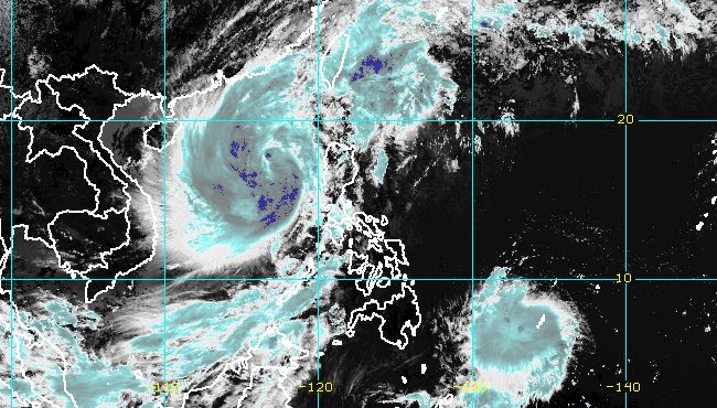
MANILA, Philippines – Paeng (Nalgae) re-intensified from a tropical storm into a severe tropical storm at 8 am on Monday, October 31, as it continued to move over the West Philippine Sea ahead of its exit from the Philippine Area of Responsibility (PAR).
The other tropical cyclone inside PAR, Queenie, strengthened from a tropical depression into a tropical storm also at 8 am. It has been given the international name Banyan.
Paeng
Paeng’s maximum sustained winds increased from 85 kilometers per hour to 95 km/h, its previous peak, said the Philippine Atmospheric, Geophysical, and Astronomical Services Administration (PAGASA) in a bulletin released past 11 am on Monday.
The severe tropical storm’s gustiness is now up to 115 km/h from the previous 105 km/h.
PAGASA expects Paeng to strengthen further within 12 to 24 hours, but it may start weakening late Wednesday, November 2, or on Thursday, November 3.
The severe tropical storm was last spotted 375 kilometers west of Dagupan City, Pangasinan, moving northwest at 10 km/h.
It is still seen to exit PAR on Monday afternoon or evening.
There may still be rain from Paeng until Monday afternoon, particularly in these areas:
Moderate to heavy rain
- Batanes
- Zambales
- Bataan
Light to moderate rain, with at times heavy rain
- Ilocos Region
- Cordillera Administrative Region
- Mimaropa
- rest of Central Luzon
- Babuyan Islands
- Cavite
- Batangas
- Laguna
- southern part of Quezon
- Western Visayas
PAGASA said floods and landslides “are likely to slowly subside,” except in areas which saw significant rainfall the past days or those still hit by persistent heavy rain.
Strong winds may also persist, with Signal No. 1 still raised for these parts of Luzon as of 11 am on Monday:
- southern part of Ilocos Norte (Badoc, Pinili, Banna, Nueva Era, Batac City, Paoay, Marcos, Currimao, Dingras, Solsona, Sarrat, San Nicolas, Laoag City, Piddig)
- Ilocos Sur
- La Union
- Pangasinan
- western and central parts of Pampanga (Mexico, Porac, Angeles City, Santa Rita, Santa Ana, Guagua, Sasmuan, Mabalacat City, Arayat, Santo Tomas, Minalin, San Fernando City, Bacolor, Floridablanca, Magalang, Lubao)
- Abra
- Benguet
- western part of Mountain Province (Besao, Tadian, Bauko, Sabangan, Sagada)
- western part of Ifugao (Tinoc, Hungduan)
- Tarlac
- western part of Nueva Vizcaya (Santa Fe, Kayapa)
- western part of Nueva Ecija (Cuyapo, Talugtug, Nampicuan, Guimba, Licab, Quezon, Zaragoza, San Antonio, Cabiao)
- Zambales
- central and southern parts of Bataan (Orani, Abucay, Hermosa, Samal, Morong, Dinalupihan, Bagac, Balanga City, Pilar)
Signal No. 3 was the highest tropical cyclone wind signal raised during Paeng’s onslaught.
The gale warning issued at 5 am on Monday also remains in effect. PAGASA said conditions in the following seaboards are dangerous for all vessels:
- western seaboards of Northern Luzon and Central Luzon (western coast of Ilocos Norte, Ilocos Sur, La Union, Pangasinan, Zambales, Bataan) – very rough to high seas, waves 4.5 to 7 meters high
- seaboards of Southern Luzon, northern and eastern seaboards of Northern Luzon, eastern seaboard of Central Luzon (Batanes, Cagayan including Babuyan Islands, northern coast of Ilocos Norte, Isabela, Aurora, Pampanga, Bulacan, Metro Manila, Cavite, Batangas, Quezon including Polillo Islands, Occidental Mindoro including Lubang Islands, Oriental Mindoro, Marinduque, Romblon, Palawan including Calamian, Cuyo, Cagayancillo, and Kalayaan Islands) – rough to very rough seas, waves 3.1 to 5.5 meters high
Paeng may also cause moderate to rough seas in the western seaboard of the Visayas. Waves could be 1.5 to 3 meters high, which would be risky for small vessels.
Paeng had made landfall five times, all as a severe tropical storm on Saturday, October 29:
- Virac, Catanduanes – 1:10 am
- Caramoan, Camarines Sur – 1:40 am
- Buenavista, Quezon – 6 am
- Santa Cruz, Marinduque – 8:40 am
- Sariaya, Quezon – 1:40 pm
After hitting Quezon for a second time, Paeng crossed Laguna, Cavite, the Metro Manila-Rizal-Bulacan area, Pampanga, and Zambales.
Even before its landfalls in Luzon, Paeng already wreaked havoc in parts of Mindanao and the Visayas. Dozens of people died in Maguindanao del Norte landslides and flooding.

Queenie
Meanwhile, Queenie now has maximum sustained winds of 65 km/h from the previous 45 km/h, and gustiness of up to 80 km/h from the previous 55 km/h.
The tropical storm was located 815 kilometers east of northeastern Mindanao on Monday morning, moving west southwest at only 10 km/h.
PAGASA said Queenie will head west in the next 12 hours, or for the rest of Monday, before turning west northwest on Tuesday, November 1, until Wednesday morning.
By Wednesday afternoon, it is expected to move northwest toward the Caraga-Eastern Visayas area.
PAGASA also sees Queenie intensifying further on Monday, but it may start weakening late Tuesday evening or Wednesday.
Then on Friday, November 4, it is likely to weaken into a remnant low as it approaches Caraga or Eastern Visayas, added the weather bureau.
Queenie is not expected to directly affect the country until Tuesday. But starting Wednesday, light to moderate rain, with at times heavy rain, may hit these regions:
- Caraga
- Eastern Visayas
- Bicol
Signal No. 1 could be raised due to Queenie in the eastern part of Caraga and in some areas in Eastern Visayas as early as Tuesday evening.
Based on the tropical storm’s latest track and intensity forecast, Signal No. 1 is probably the highest possible wind signal.
Queenie is “less likely” to affect the country’s coastal waters on Monday.

Paeng and Queenie are the Philippines’ 16th and 17th tropical cyclones for 2022, and the fourth and fifth for October, respectively. – Rappler.com
Add a comment
How does this make you feel?


There are no comments yet. Add your comment to start the conversation.