SUMMARY
This is AI generated summarization, which may have errors. For context, always refer to the full article.
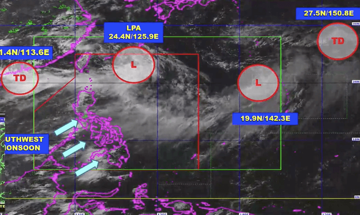
The state weather bureau said two low pressure areas (LPAs) and two tropical depressions being monitored on Tuesday, August 3, are not expected to hit the Philippines, but the southwest monsoon or hanging habagat will be bringing more rain to parts of the country.
One of the LPAs is inside the Philippine Area of Responsibility (PAR), located 580 kilometers northeast of Itbayat, Batanes, as of Tuesday afternoon.
It could develop into a tropical depression within 48 hours, but it is heading for the PAR’s northern boundary and could exit during that period, said the Philippine Atmospheric, Geophysical, and Astronomical Services Administration (PAGASA).
The other LPA, which is east of Northern Luzon, and the two tropical depressions are all outside PAR.
One of the tropical depressions is 850 kilometers west of extreme Northern Luzon, slowly heading east northeast. PAGASA Weather Specialist Joey Figuracion said it may go near PAR in the coming days.
The other tropical depression is 3,025 kilometers east northeast of extreme Northern Luzon, moving north northwest at 30 kilometers per hour. While it is very far from PAR, it is being monitored since it is part of the monsoon trough or extension, explained Figuracion.
Also on Tuesday afternoon, PAGASA said the southwest monsoon will affect the following areas in the next 24 hours:
Monsoon rain
- Ilocos Region
- Batanes
- Babuyan Group of Islands
- Abra
- Apayao
- Benguet
- Zambales
- Bataan
Occasional rain
- rest of Cagayan Valley
- rest of Cordillera Administrative Region
- Metro Manila
- Tarlac
- Pampanga
- Bulacan
- Cavite
- Batangas
- Rizal
- Occidental Mindoro
- Oriental Mindoro
- Palawan
Isolated rain showers or thunderstorms
- rest of the Philippines
Across the country, flash floods and landslides are possible during periods of moderate to heavy rain or severe thunderstorms. (READ: FAST FACTS: Tropical cyclones, rainfall advisories)
The Philippines has had six tropical cyclones in 2021. An average of 20 tropical cyclones form within or enter PAR each year. (READ: LIST: PAGASA’s names for tropical cyclones in 2021)
These are PAGASA’s latest available estimates per month:
2021
- August – 2 or 3
- September – 2 or 3
- October – 2 or 3
- November – 2 or 3
- December – 1 or 2
2022
- January – 0 or 1
The rainy season has been underway since early June. – Rappler.com
Add a comment
How does this make you feel?


There are no comments yet. Add your comment to start the conversation.