SUMMARY
This is AI generated summarization, which may have errors. For context, always refer to the full article.
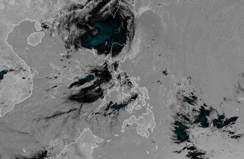
MANILA, Philippines – Typhoon Jenny (Koinu) weakened as it made landfall in Pingtung County, Taiwan, while the effect of the enhanced southwest monsoon or habagat on western portions of Luzon also started easing on Thursday morning, October 5.
Taiwan is within the Philippine Area of Responsibility (PAR), given its proximity to the northernmost province of Batanes.
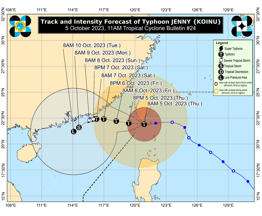
In a briefing past 11 am on Thursday, the Philippine Atmospheric, Geophysical, and Astronomical Services Administration (PAGASA) said Jenny was already 180 kilometers northwest of Itbayat, Batanes, slowly moving west.
The typhoon’s maximum sustained winds decreased from 175 kilometers per hour to 155 km/h, while its gustiness eased from 215 km/h to 190 km/h.
Though Jenny has weakened, it is still bringing heavy rain to Batanes on Thursday.
Tropical cyclone wind signals also remain in effect in the following areas as of 11 am:
Signal No. 3
Storm-force winds (89 to 117 km/h), moderate to significant threat to life and property
- northern part of Batanes (Itbayat)
Signal No. 2
Gale-force winds (62 to 88 km/h), minor to moderate threat to life and property
- rest of Batanes
Signal No. 1
Strong winds (39 to 61 km/h), minimal to minor threat to life and property
- Babuyan Islands
- northern part of mainland Cagayan (Santa Ana, Gonzaga, Buguey, Santa Teresita, Lal-lo, Camalaniugan, Pamplona, Claveria, Aparri, Ballesteros, Abulug, Allacapan, Sanchez Mira, Santa Praxedes, Lasam, Gattaran)
- northern part of Apayao (Calanasan, Pudtol, Luna, Santa Marcela, Flora)
- northern part of Ilocos Norte (Piddig, Bangui, Vintar, Burgos, Pagudpud, Bacarra, Adams, Pasuquin, Carasi, Dumalneg, Laoag City)
ALSO ON RAPPLER
- Price pain: Inflation soars for second straight month to 6.1% in September 2023
- Change phone numbers? What to do if you’re a potential victim in PhilHealth breach
- PH cyclist Ariana Evangelista suspended after positive drug test in Asian Games
- Stan by Me: Titas of DonBelle and their love for Donny and Belle
Jenny did not make landfall in the Philippines. It is expected to leave PAR on Thursday afternoon or evening.
Outside PAR, it will keep moving slowly over the Taiwan Strait and the coastal waters of southeastern China.
It will also weaken further due to dry air, and may just be a tropical depression by Sunday, October 8.
Meanwhile, the gale warning released at 5 am on Thursday due to Jenny is still in effect for these seaboards:
- seaboard of extreme Northern Luzon (Batanes) – rough to very high seas, waves 4.5 to 10.3 meters high, travel risky for all vessels
- northern and western seaboards of Northern Luzon (Ilocos Norte, northern coast of Cagayan including Babuyan Islands) – rough to very rough seas, waves 2.8 to 4.5 meters high, travel risky for small vessels
- eastern seaboard of Northern Luzon (eastern coast of Cagayan, Isabela) – rough to very rough seas, waves 2.8 to 4.5 meters high, travel risky for small vessels
In a separate advisory at 11 am on Thursday, PAGASA said the southwest monsoon’s effect already weakened. It had been enhanced by Jenny in the past few days.
But the southwest monsoon may still trigger scattered rain showers and thunderstorms in Zambales, Bataan, Occidental Mindoro, and the northern part of Palawan, including the Calamian, Cuyo, and Kalayaan islands, in the next 24 hours.
Gusty conditions due to the southwest monsoon will also persist in the southern part of Aurora, Romblon, and parts of Calabarzon, Metro Manila, Bicol, and Bataan.
Jenny is the Philippines’ 10th tropical cyclone for 2023 and the second for September, having developed last Friday, September 29.
PAGASA expects four to seven tropical cyclones to form within or enter PAR from October 2023 to March 2024. For October alone, there may be two or three tropical cyclones. – Rappler.com
Add a comment
How does this make you feel?


There are no comments yet. Add your comment to start the conversation.