SUMMARY
This is AI generated summarization, which may have errors. For context, always refer to the full article.

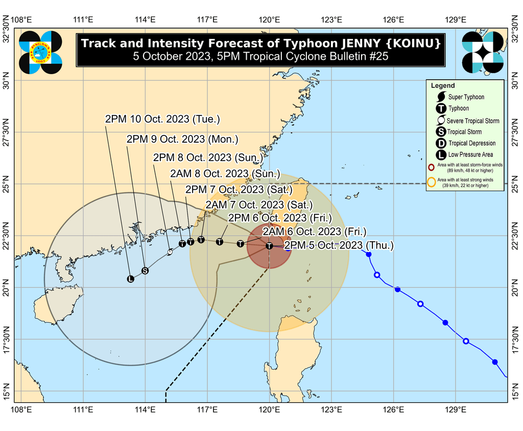
MANILA, Philippines – Typhoon Jenny (Koinu) left the Philippine Area of Responsibility (PAR) early Thursday afternoon, October 5, but it is still affecting some areas in Northern Luzon due to its size.
As of 4 pm on Thursday, Jenny was already 275 kilometers west northwest of Itbayat, Batanes.
The typhoon accelerated, moving west at 15 kilometers per hour (km/h) after earlier inching across Taiwan, which is part of PAR.
It did not make landfall in the Philippines, but hit Taiwan’s Pingtung County on Thursday morning.
As expected, Jenny weakened after crossing Taiwan’s rugged terrain, with its maximum sustained winds down from 155 km/h to 140 km/h.
The typhoon’s gustiness also eased from 190 km/h to 170 km/h.
It is seen to weaken further due to dry air, and may just be a tropical depression by late Sunday, October 8.
The Philippine Atmospheric, Geophysical, and Astronomical Services Administration (PAGASA) said in a briefing past 5 pm on Thursday that Jenny will still bring rain to Batanes despite its exit.
Winds from the typhoon also continue to be felt. Signal No. 3 has been lifted as of 5 pm, but Signal Nos. 1 and 2 are still in effect for the following areas:
Signal No. 2
Gale-force winds (62 to 88 km/h), minor to moderate threat to life and property
- northern part of Batanes (Itbayat)
Signal No. 1
Strong winds (39 to 61 km/h), minimal to minor threat to life and property
- rest of Batanes
- Babuyan Islands
- northwestern part of Cagayan (Pamplona, Sanchez Mira, Claveria, Santa Praxedes, Abulug)
- northern part of Apayao (Calanasan, Luna)
- northern part of Ilocos Norte (Pagudpud, Adams, Dumalneg, Bangui, Burgos, Pasuquin, Vintar)
In addition, PAGASA issued a new gale warning at 5 pm, as Jenny is still affecting these coastal waters:
- seaboard of extreme Northern Luzon (Batanes) – rough to very high seas, waves 4.5 to 8 meters high, travel risky for all vessels
- northern and western seaboards of Northern Luzon (Ilocos Norte, northern coast of Cagayan including Babuyan Islands) – rough to very rough seas, waves 2.8 to 4.5 meters high, travel risky for small vessels
ALSO ON RAPPLER
- Even with price caps, rice inflation skyrockets to 14-year high in September
- Meggie Ochoa rules Asian Games jiu-jitsu, wins 2nd PH gold in Hangzhou
- Justin Brownlee’s China-killing shots ‘will be remembered forever,’ says Tim Cone
- [WATCH] Rappler Live Jam: Maki
Jenny also continues to enhance the southwest monsoon or habagat, though the effect of the latter already weakened earlier on Thursday.
Still, scattered rain showers and thunderstorms are hitting Metro Manila, Central Luzon, Calabarzon, and Mimaropa due to the southwest monsoon.
Gusty conditions due to the southwest monsoon also persist in the southern part of Aurora, Romblon, and parts of Calabarzon, Metro Manila, Bicol, and Bataan.
Jenny was the Philippines’ 10th tropical cyclone for 2023 and the second for September, having developed last Friday, September 29.
PAGASA expects four to seven tropical cyclones to form within or enter PAR from October 2023 to March 2024. For October alone, there may be two or three tropical cyclones. – Rappler.com
Add a comment
How does this make you feel?


There are no comments yet. Add your comment to start the conversation.