SUMMARY
This is AI generated summarization, which may have errors. For context, always refer to the full article.
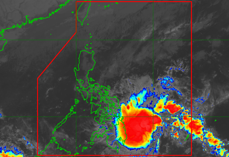
MANILA, Philippines – A low pressure area (LPA) located east of Mindanao developed into a tropical depression at 2 am on Sunday, December 17, and was given the local name Kabayan.
Tropical Depression Kabayan is the Philippines’ 11th tropical cyclone for 2023 and the first for December.
As of 7 am on Sunday, Kabayan was already 460 kilometers east of Davao City, moving west at 15 kilometers per hour (km/h).
The tropical depression has maximum sustained winds of 55 km/h and gustiness of up to 70 km/h.
“Kabayan is forecast to follow a generally west northwestward path across the Philippine archipelago over the next two days and is likely to maintain its strength until its initial landfall over Mindanao. However, the possibility of reaching tropical storm category pre-landfall is not ruled out,” said the Philippine Atmospheric, Geophysical, and Astronomical Services Administration (PAGASA).
PAGASA warned that Kabayan will be bringing heavy rain on Sunday and on Monday, December 18.
Sunday, December 17
- 100-200 millimeters (mm): Surigao del Sur
- 50-100 mm: Dinagat Islands, Surigao del Norte, Agusan del Norte, eastern part of Agusan del Sur, northern part of Davao Oriental, northern part of Davao de Oro
Monday, December 18
- 100-200 mm: Surigao del Sur, Surigao del Norte, Dinagat Islands, Southern Leyte
- 50-100 mm: southern parts of Eastern Samar and Samar; eastern and southern parts of Leyte, Bohol, Cebu, Negros Oriental, Siquijor, Camiguin, and Misamis Oriental; northern parts of Bukidnon, Agusan del Sur, and Agusan del Norte
Floods and landslides are likely.
The weather bureau added that the shear line may also trigger heavy rain in the eastern part of Southern Luzon on Sunday. In particular, Bicol and Quezon could have scattered rain showers and thunderstorms.
ALSO ON RAPPLER
- The Green Report: Is COP28 really the ‘beginning of end’ for fossil fuels?
- In PH’s oldest stone church, Simbang Gabi brings Catholics back to 16th century
- Time to feast! Food gifts, treats to sweeten up the holidays
Signal No. 1 is also raised in the following areas in the Visayas and Mindanao as of 8 am on Sunday, which means they should expect strong winds from Kabayan:
- southern part of Samar (Basey, Santa Rita, Marabut, Talalora, Villareal, Pinabacdao)
- southern part of Eastern Samar (Maydolong, Borongan City, Quinapondan, Guiuan, Lawaan, Balangiga, Llorente, Giporlos, Salcedo, Balangkayan, General MacArthur, Hernani, Mercedes)
- Leyte
- Southern Leyte
- Bohol
- Camotes Islands
- Dinagat Islands
- Surigao del Norte
- Surigao del Sur
- Agusan del Norte
- Agusan del Sur
- northern part of Davao Oriental (Cateel, Boston, Baganga)
- northern part of Davao de Oro (Monkayo, Laak)
- Misamis Oriental
- Camiguin
- northern part of Bukidnon (Impasug-ong, Malitbog, Manolo Fortich, Sumilao, Libona, Baungon, Cabanglasan, Malaybalay City)
PAGASA also said the surge of the northeast monsoon or amihan will cause gusty conditions on Sunday and Monday in Batanes, Babuyan Islands, Ilocos Norte, Ilocos Sur, Aurora, Bataan, Bulacan, Rizal, Quezon, Lubang Island, Marinduque, Cuyo Islands, Bicol, Visayas, northern and eastern parts of mainland Cagayan, eastern parts of Isabela and Nueva Ecija, and parts of the Cordillera Administrative Region, Zambales, Pampanga, Cavite, Occidental Mindoro, and Oriental Mindoro.
Due to Kabayan and the surge of the northeast monsoon, a gale warning was issued for coastal waters along the seaboard of Northern Luzon and the eastern seaboards of the Visayas and Mindanao. The weather bureau warned that travel is risky for small vessels.

PAGASA sees Kabayan making landfall in Surigao del Sur or Davao Oriental on Sunday night or early Monday morning. Then it could “cross the rugged terrain of Mindanao, and emerge over [the] Bohol Sea or Sulu Sea” Monday noon or afternoon.
“Due to frictional effects associated with landfall, Kabayan is forecast to weaken over land and the possibility of being downgraded into [an LPA] while over land or after emerging over the sea is not ruled out – although in such a case, redevelopment may still occur over the Sulu Sea,” the weather bureau said.
Kabayan could then move across the Sulu Sea, south of Cuyo Islands, until early Tuesday morning, December 19. Then it might make another landfall in the central or southern part of Palawan by Tuesday morning, before finally emerging over the Philippine Sea by noon or early afternoon that day.
“Afterwards, Kabayan may pass near or over Kalayaan Islands in the West Philippine Sea,” PAGASA added.
The weather bureau emphasized that forecasts for the tropical depression’s track and intensity may still change.
PAGASA previously estimated that one or two tropical cyclones could form within or enter the Philippine Area of Responsibility in December. – Rappler.com
Add a comment
How does this make you feel?


There are no comments yet. Add your comment to start the conversation.