SUMMARY
This is AI generated summarization, which may have errors. For context, always refer to the full article.
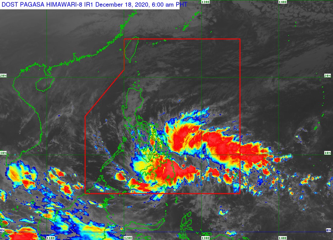
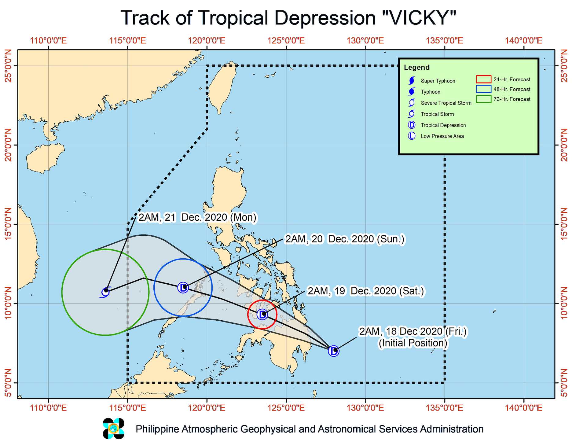
The low pressure area (LPA) off Davao City developed into a tropical depression at 2 am on Friday, December 18.
It was given the local name Vicky, as the Philippines’ 22nd tropical cyclone for 2020 and the 1st for December. (READ: LIST: PAGASA’s names for tropical cyclones in 2020)
In a bulletin issued 5 am on Friday, the Philippine Atmospheric, Geophysical, and Astronomical Services Administration (PAGASA) said Vicky was located 210 kilometers east of Davao City.
The tropical depression is moving west northwest at 15 kilometers per hour (km/h).
It is projected to make landfall in the Davao Oriental-Surigao del Sur area in the next 12 hours, then cross Mindanao. After crossing Mindanao, it is seen to emerge over the Bohol Sea early Saturday morning, December 19, pass close to or over Siquijor, then make its 2nd landfall in the southern part of Negros Island. By Saturday morning or afternoon, it is likely to be already over the Sulu Sea.
So far, Vicky has maximum sustained winds of 45 km/h and gustiness of up to 55 km/h. PAGASA said it is expected to remain a tropical depression while crossing Mindanao. (READ: FAST FACTS: Tropical cyclones, rainfall advisories)
Signal No. 1 is now raised in parts of the Visayas and Mindanao, plus a couple of areas in Luzon. The state weather bureau said the affected areas will have “strong breeze to near gale conditions” when Vicky crosses land.
- Cuyo Islands
- Cagayancillo Islands
- southern part of Leyte (Baybay City, Javier, Abuyog, Mahaplag, Inopacan, Hindang, Hilongos, Bato, Matalom, Palompon, Merida, Isabel)
- Southern Leyte
- central and southern parts of Cebu (Borbon, Tabuelan, Tuburan, Sogod, Catmon, Carmen, Asturias, Danao City, Compostela, Liloan, Consolacion, Mandaue City, Lapu-Lapu City, Cordoba, Balamban, Cebu City, Talisay City, Toledo City, Minglanilla, Naga City, Pinamungahan, San Fernando, Aloguinsan, Carcar, Barili, Sibonga, Dumanjug, Ronda, Alcantara, Moalboal, Argao, Dalaguete, Badian, Alegria, Alcoy, Boljoon, Oslob, Malabuyoc, Ginatilan, Samboan, Santander) including Camotes Islands
- Bohol
- Siquijor
- Negros Oriental
- Negros Occidental
- Guimaras
- central and southern parts of Iloilo (Ajuy, Barotac Viejo, San Enrique, San Rafael, Passi City, Bingawan, Calinog, Lambunao, Janiuay, Banate, Anilao, Dingle, Duenas, Badiangan, Barotac Nuevo, Zarraga, Pototan, Dumangas, Mina, New Lucena, Santa Barbara, Leganes, Iloilo City, Pavia, Cabatuan, Maasin, Alimodian, San Miguel, Leon, Oton, Tigbauan, Tubungan, Guimbal, Igbaras, Miagao, San Joaquin)
- southern part of Antique (Valderrama, San Remigio, Sibalom, Hamtic, Tobias Fornier, Anini-y, Bugasong, Laua-an, Patnongon, San Jose, Belison)
- Dinagat Islands
- Surigao del Norte
- Surigao del Sur
- Agusan del Norte
- Agusan del Sur
- Davao Oriental
- Davao de Oro
- Davao del Norte
- Davao City
- northern part of Davao del Sur (Santa Cruz, Digos City, Bansalan, Magsaysay, Matanao, Hagonoy)
- Camiguin
- Bukidnon
- Misamis Oriental
- Misamis Occidental
- Lanao del Norte
- Lanao del Sur
- northern part of Maguindanao (Kabuntalan, Northern Kabuntalan, Sultan Kudarat, Sultan Mastura, Parang, Barira, Matanog, Buldon)
- Cotabato City
- North Cotabato
- northern part of Zamboanga del Sur (Pagadian City, Midsalip, Labangan, Tukuran, Aurora, Tambulig, Josefina, Molave, Ramon Magsaysay, Sominot, Mahayag, Dumingag)
- northern part of Zamboanga del Norte (Siayan, Sindangan, Bacungan, Jose Dalman, Manukan, President Manuel A. Roxas, Sergio Osmeña Sr, Katipunan, Dipolog City, Polanco, Pinan, Mutia, La Libertad, Dapitan City, Sibutad, Rizal)
PAGASA also warned that the combined effects of Vicky and the tail-end of a frontal system or shear line will cause rain on Friday and Saturday. Floods and landslides are possible.
Friday, December 18
Moderate to heavy rain, with at times intense rain
- Caraga
- Davao Oriental
- Davao de Oro
- Davao del Norte
- Bukidnon
- Misamis Oriental
- Camiguin
- Southern Leyte
- Leyte
- Bohol
Light to moderate rain, with at times heavy rain
- rest of Davao Region
- rest of Northern Mindanao
- Lanao del Sur
- Zamboanga del Norte
- rest of Visayas
- Bicol
- southern part of Quezon
Saturday, December 19
Moderate to heavy rain, with at times intense rain
- Bicol
- Quezon
- northern part of Palawan including Calamian and Cuyo Islands
- Eastern Visayas
- Central Visayas
Light to moderate rain, with at times heavy rain
- rest of Calabarzon
- rest of Mimaropa
- mainland Cagayan Valley
- Apayao
- Kalinga
- Mountain Province
- Ifugao
- Bulacan
- Metro Manila
- rest of Visayas
- Camiguin
- Dinagat Islands
Vicky and the surge of the northeast monsoon or hanging amihan combined will also cause rough to very rough seas in the next 24 hours. Waves will be 2.5 to 4.5 meters high in the following:
- entire seaboards of Northern Luzon
- seaboard of Aurora
- eastern seaboard of Quezon including Polillo Islands
- seaboard of Camarines Norte
- northern seaboard of Camarines Sur
- northern and eastern seaboards of Catanduanes
- eastern seaboard of Albay including Rapu-Rapu Islands
- eastern seaboard of Sorsogon
- northern and eastern seaboards of Northern Samar
- eastern seaboard of Eastern Samar including Homonhon Island
PAGASA added that seas will be moderate to rough, with waves 2 to 4 meters high, in the coastal waters of areas under Signal No. 1.
Travel is risky, especially for small sea vessels, said the state weather bureau.
Vicky could leave the Philippine Area of Responsibility (PAR) on Sunday, December 20.
For the next 6 months, these are PAGASA’s estimates for tropical cyclones inside PAR:
- December 2020 – 1 or 2
- January 2021 – 0 or 1
- February 2021 – 0 or 1
- March 2021 – 0 or 1
- April 2021 – 0 or 1
- May 2021 – 0 or 1
La Niña has been underway since October, causing more rain than usual in the country. – Rappler.com
Add a comment
How does this make you feel?


There are no comments yet. Add your comment to start the conversation.