SUMMARY
This is AI generated summarization, which may have errors. For context, always refer to the full article.
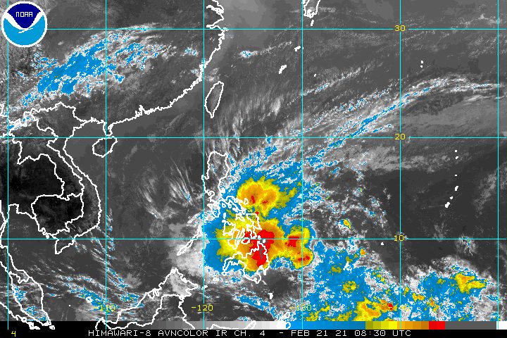
Tropical Storm Auring (Dujuan) slightly accelerated late Sunday afternoon, February 21, still dumping heavy rain in parts of Mindanao and the Visayas ahead of its landfall.
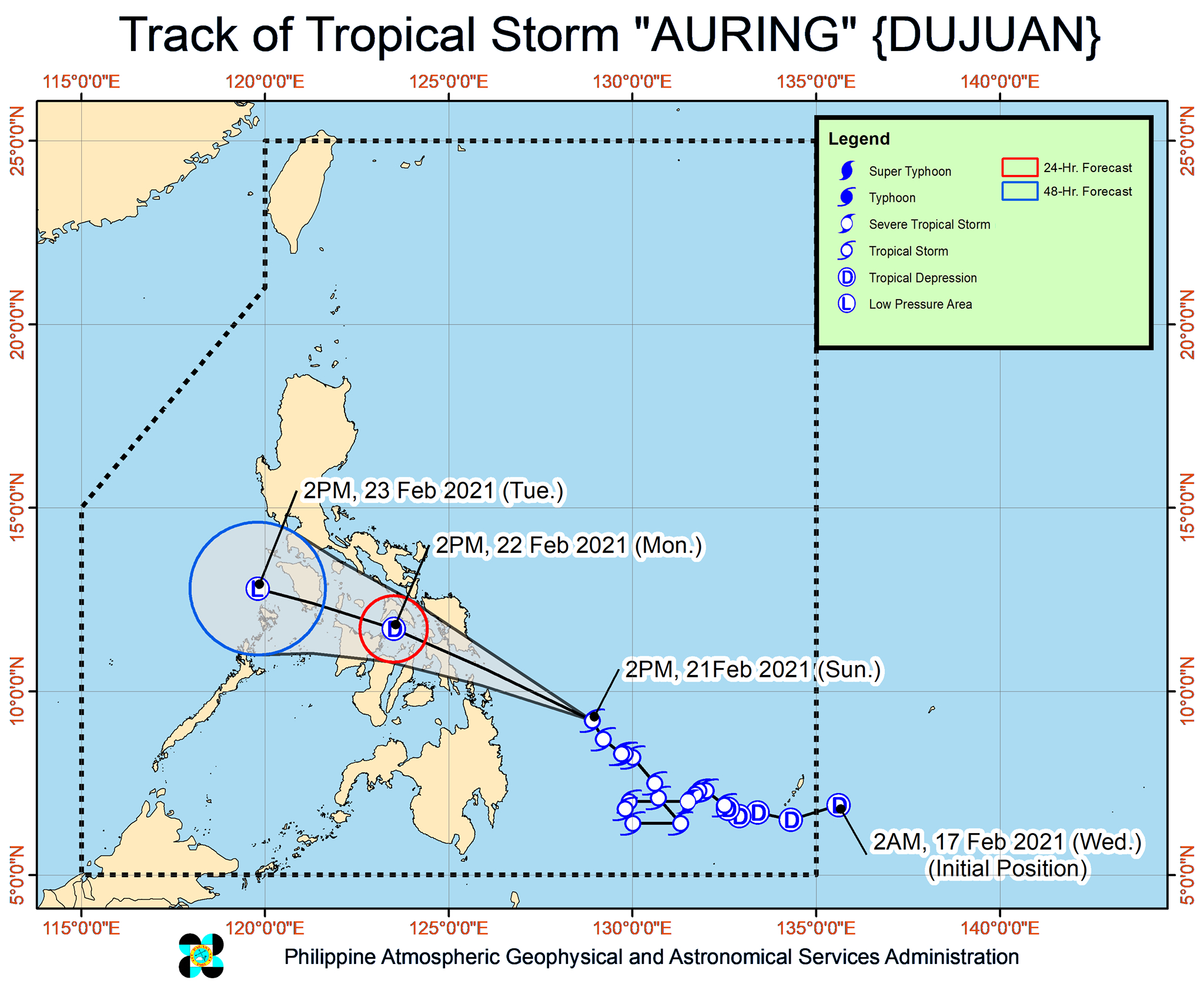
In its 5 pm bulletin on Sunday, the Philippine Atmospheric, Geophysical, and Astronomical Services Administration (PAGASA) said Auring is already 355 kilometers east of Surigao City, Surigao del Norte.
The tropical storm is now moving northwest toward the Eastern Visayas-Caraga area at 20 kilometers per hour (km/h) from the previous 15 km/h early Sunday afternoon.
Its projected landfall in the Dinagat Islands-Eastern Samar-Leyte area has been further pushed back to Monday morning, February 22, after its generally slow pace the past few days.
At the moment, Auring continues to have maximum sustained winds of 65 km/h and gustiness of up to 80 km/h.
PAGASA now expects Auring to maintain its strength in the next 12 hours, though it is not ruling out the possibility that it would weaken into a tropical depression before hitting land.
After landfall, Auring is expected to “weaken considerably due to significant terrain interaction and the increasing wind shear.” It could become just a remnant low in 48 hours or less. (READ: FAST FACTS: Tropical cyclones, rainfall advisories)
Though Auring has yet to reach land, it has already caused massive floods in Surigao del Sur. The province and several other areas will continue to see rain from the tropical storm, which may trigger more floods as well as landslides.
Sunday, February 21, until Monday morning, February 22
Moderate to heavy rain
- Caraga
- Misamis Oriental
- Bukidnon
- Camiguin
- Eastern Visayas
- Catanduanes
- Albay
- Sorsogon
Light to moderate rain, with at times heavy rain
- rest of Northern Mindanao
- Zamboanga Peninsula
- Davao Oriental
- Davao de Oro
- rest of Visayas
- rest of Bicol
- Mimaropa
- Quezon
Monday morning, February 22, until Tuesday morning, February 23
Moderate to heavy rain
- Bicol
- Marinduque
- Northern Samar
- Eastern Samar
- Samar
Light to moderate rain, with at times heavy rain
- rest of Mimaropa
- Quezon
- Aurora
- Isabela
- Cagayan
- rest of Visayas
Below are the areas under tropical cyclone wind signals as of 5 pm on Sunday, with more places added to the list. Aside from Auring, the surge of the northeast monsoon or hanging amihan is also driving windy conditions.
Signal No. 2 (gale-force winds)
- central and southern parts of Eastern Samar (Taft, Sulat, San Julian, Borongan City, Maydolong, Balangkayan, Llorente, Hernani, General MacArthur, Quinapondan, Balangiga, Lawaan, Giporlos, Salcedo, Mercedes, Guiuan)
- central and southern parts of Samar (Hinabangan, Calbiga, Pinabacdao, Villareal, Basey, Marabut, Santa Rita)
- eastern part of Leyte (Babatngon, Tacloban City, San Miguel, Alangalang, Santa Fe, Palo, Tanauan, Pastrana, Dagami, Tabontabon, Tolosa, Julita, Burauen, Dulag, La Paz, Mayorga, MacArthur, Javier, Abuyog, Mahaplag)
- eastern part of Southern Leyte (Silago, Sogod, Hinunangan, Libagon, Saint Bernard, Hinundayan, Anahawan, San Juan, Liloan, San Francisco, San Ricardo, Pintuyan)
- Dinagat Islands
- Surigao del Norte including Siargao and Bucas Grande Islands
Signal No. 1 (strong breeze to near-gale conditions, with occasionally higher gusts)
- Sorsogon
- Masbate including Ticao and Burias Islands
- Albay
- Catanduanes
- eastern part of Camarines Sur (Caramoan, Presentacion, Sagñay, Buhi, Iriga City, Nabua, Bato, Balatan)
- eastern part of Romblon (Magdiwang, San Fernando, Cajidiocan)
- Northern Samar
- rest of Eastern Samar
- rest of Samar
- Biliran
- rest of Leyte
- rest of Southern Leyte
- Cebu
- Bohol
- Siquijor
- Negros Oriental
- northern and central parts of Negros Occidental (Kabankalan City, Himamaylan City, Binalbagan, Isabela, Moises Padilla, Hinigaran, La Castellana, Pontevedra, San Enrique, La Carlota City, Pulupandan, Valladolid, Bago City, Murcia, Bacolod City, Talisay City, Silay City, Enrique B. Magalona, Victorias City, Manapla, Cadiz City, Sagay City, Escalante City, Toboso, Calatrava, San Carlos City, Salvador Benedicto)
- northern and central parts of Iloilo (Carles, Balasan, Estancia, Batad, San Dionisio, Sara, Concepcion, Lemery, Ajuy, San Rafael, Passi City, Bingawan, Calinog, Lambunao, Dueñas, San Enrique, Dingle, Anilao, Banate, Janiuay, Badiangan, Pototan, Barotac Nuevo, Dumangas, Mina, Maasin, Alimodian, Leon, Tigbauan, Oton, Iloilo City, Pavia, San Miguel, Cabatuan, Santa Barbara, New Lucena, Zarraga, Leganes, Barotac Viejo)
- Capiz
- Guimaras
- eastern part of Aklan (Tangalan, Malinao, Makato, Lezo, Numancia, Kalibo, New Washington, Batan, Altavas, Balete, Banga, Madalag, Libacao)
- Surigao del Sur
- Agusan del Norte
- Agusan del Sur
- Davao Oriental
- Davao de Oro
- Davao del Norte
- Camiguin
- Misamis Oriental
- Bukidnon
The rest of the Visayas and the rest of Bicol, as well as Calabarzon, Mimaropa, and Aurora, could have windy conditions similar to areas under Signal No. 1.
Here is PAGASA’s updated forecast for coastal waters in the next 24 hours:
Rough to very rough seas
Travel is risky for all types of vessels
- seaboards of areas under tropical cyclone wind signals (waves 2.6 to 4.5 meters high)
- eastern seaboard of Luzon not under tropical cyclone wind signals (waves 2.6 to 4.5 meters high)
Rough seas
Travel is risky for all types of vessels
- southern seaboard of Luzon (including eastern seaboard of Palawan), remaining seaboards of Visayas, and northern, eastern, and western seaboards of Mindanao that are not under tropical cyclone wind signals (waves 2.5 to 4 meters high)
Moderate to rough seas
Small vessels must take precautionary measures, inexperienced mariners should avoid navigation
- rest of the seaboards of the Philippines (waves 1.2 to 3 meters high)
Auring is the Philippines’ first tropical cyclone for 2021.
An average of 20 tropical cyclones form within or enter the Philippine Area of Responsibility (PAR) each year. (READ: LIST: PAGASA’s names for tropical cyclones in 2021)
These are PAGASA’s latest estimates for the number of tropical cyclones inside PAR in the next 6 months:
- February – 0 or 1
- March – 0 or 1
- April – 0 or 1
- May – 0 or 1
- June – 1 or 2
- July – 2 or 3
PAGASA earlier said La Niña is expected to continue until March 2021, causing above normal rainfall in the country. The onset of La Niña was declared in October 2020. – Rappler.com
Add a comment
How does this make you feel?


There are no comments yet. Add your comment to start the conversation.