SUMMARY
This is AI generated summarization, which may have errors. For context, always refer to the full article.
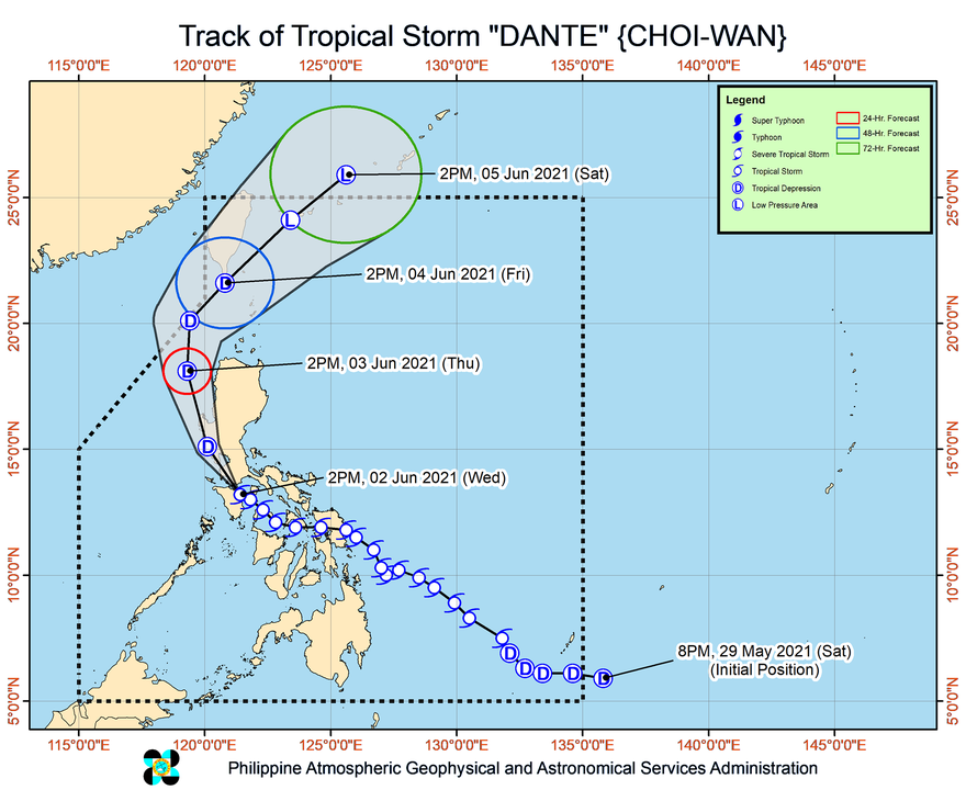
Tropical Storm Dante (Choi-wan) made its sixth landfall in Pola, Oriental Mindoro, at 2 pm on Wednesday, June 2, then started heading for the southwestern coast of Batangas.
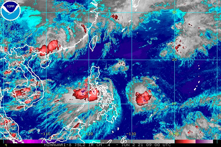
The Philippine Atmospheric, Geophysical, and Astronomical Services Administration (PAGASA) said in a bulletin released past 5 pm that Dante was located over the coastal waters of Calapan, Oriental Mindoro.
The tropical storm was moving west northwest at only 15 kilometers per hour, slower than its previous speed of 25 km/h.
PAGASA said Dante may pass near or in the vicinity of the southwestern part of Batangas before making another landfall in Bataan on Wednesday evening. Then it could cross Zambales and Pangasinan before finally emerging over the West Philippine Sea on Thursday morning, June 3.
These were Dante’s first six landfalls:
Tuesday, June 1
- Sulat, Eastern Samar – 8:30 pm
Wednesday, June 2
- Cataingan, Masbate – 1 am
- Balud, Masbate – 3:30 am
- Romblon, Romblon – 8 am
- San Agustin, Romblon – 8:50 am
- Pola, Oriental Mindoro – 2 pm
Dante continued to have maximum sustained winds of 65 km/h and gustiness of up to 90 km/h late Wednesday afternoon.
But it is expected to weaken into a tropical depression on Wednesday evening or Thursday morning as it hits the rugged terrain of mainland Luzon, said PAGASA. By Saturday, June 5, it could already be just a low pressure area.
Despite the projected weakening, Dante remains a threat. Below is PAGASA’s latest rainfall forecast for the rest of Wednesday until Thursday afternoon.
Moderate to heavy rain, with at times intense rain
- Cavite
- Batangas
- Romblon
- Marinduque
- Occidental Mindoro
- Oriental Mindoro
- Bataan
- Zambales
- Pangasinan
Moderate to heavy rain
- rest of Central Luzon
- rest of Calabarzon
- Metro Manila
- northern part of Palawan including Calamian, Cuyo, and Cagayancillo Islands
- Aklan
- Antique
Light to moderate rain, with at times heavy rain
- Camarines Norte
- Camarines Sur
- La Union
- Ilocos Sur
- Mountain Province
- Kalinga
- Abra
- Benguet
- Nueva Vizcaya
- Quirino
- rest of Mimaropa
Residents are advised to stay alert for floods and landslides. (READ: FAST FACTS: Tropical cyclones, rainfall advisories)
Meanwhile, all of the areas left under tropical cyclone wind signals are in Luzon, except for the northwestern part of Antique. Here is the full list as of 5 pm on Wednesday:
Signal No. 2
Damaging gale-force winds prevailing or expected within 24 hours
- northern and central parts of Oriental Mindoro (Roxas, Bongabong, San Teodoro, Puerto Galera, Baco, Calapan City, Naujan, Victoria, Socorro, Pola, Pinamalayan, Gloria, Bansud)
- northern and central parts of Occidental Mindoro (Sablayan, Santa Cruz, Paluan, Mamburao, Abra de Ilog) including Lubang Islands
- Batangas
- Cavite
- Bataan
- southwestern part of Bulacan (Calumpit, Bulacan, Malolos City, Paombong, Hagonoy)
- western part of Pampanga (Masantol, Macabebe, Sasmuan, Lubao, Floridablanca, Porac, Guagua, Santa Rita, Angeles City, Mabalacat City, Minalin, Bacolor)
- Zambales
- western part of Tarlac (Bamban, Capas, San Jose, Mayantoc, Camiling, Santa Ignacia, San Clemente)
- western part of Pangasinan (Bolinao, Anda, Bani, Agno, Burgos, Infanta, Dasol, Alaminos City, Mabini, Sual, Labrador, Bugallon, Aguilar, Mangatarem, Bayambang, Urbiztondo, Basista, Malasiqui, San Carlos City, Santa Barbara, Mangaldan, Dagupan City, Calasiao, Binmaley, Lingayen)
Signal No. 1
Strong winds prevailing or expected within 36 hours
- Marinduque
- western part of Romblon (Romblon, San Agustin, Santa Maria, Odiongan, Alcantara, Looc, Ferrol, Santa Fe, San Jose, San Andres, Calatrava, Corcuera, Banton, Concepcion)
- rest of Oriental Mindoro
- rest of Occidental Mindoro
- western part of Quezon (Sampaloc, Lucban, Tayabas City, Dolores, Tiaong, San Antonio, Candelaria, Sariaya, Lucena City, Pagbilao, Padre Burgos, Agdangan, Atimonan, Unisan, Plaridel)
- Laguna
- Metro Manila
- Rizal
- rest of Bulacan
- rest of Pampanga
- rest of Tarlac
- western part of Nueva Ecija (Science City of Muñoz, Lupao, Cuyapo, Talugtug, Guimba, Nampicuan, Quezon, Licab, Santo Domingo, Talavera, Cabanatuan City, Santa Rosa, Aliaga, Zaragoza, Jaen, San Antonio, Cabiao, San Isidro, San Leonardo, Gapan City, Peñaranda)
- rest of Pangasinan
- southern part of Benguet (Itogon, Tuba, Sablan, Baguio City, La Trinidad, Kapangan, Tublay)
- La Union
- northwestern part of Antique (Caluya)
PAGASA said winds in areas under Signal No. 2 could bring “generally light to moderate damage to structures and vegetation,” while winds in areas under Signal No. 1 may cause “generally very light damage.”
As for coastal conditions, here is the state weather bureau’s updated forecast:
Rough to very rough seas (waves 2.5 to 4 meters high)
Travel is risky for small vessels, while “mariners without the proper experience should immediately seek safe harbor”
- seaboards of areas under Signal No. 2
Moderate to rough seas (waves 1.2 to 3 meters high)
Small vessels must take precautionary measures, while inexperienced mariners should avoid venturing out to sea
- seaboards of areas under Signal No. 1
- eastern seaboard of Bicol
- remaining seaboards of Visayas
- seaboard of Caraga
- northern seaboard of Northern Mindanao
- eastern seaboard of Davao Oriental
Dante is the Philippines’ fourth tropical cyclone for 2021. The country has an average of 20 tropical cyclones every year. (READ: LIST: PAGASA’s names for tropical cyclones in 2021)
For June to November, PAGASA estimates the following number of tropical cyclones inside the Philippine Area of Responsibility:
- June – 1 to 3
- July – 2 to 4
- August – 2 or 3
- September – 2 or 3
- October – 2 or 3
- November – 2 or 3
PAGASA said on Wednesday that the criteria for the declaration of the rainy season could soon be met in the coming days, given the rain from Dante. – Rappler.com
Add a comment
How does this make you feel?


There are no comments yet. Add your comment to start the conversation.