SUMMARY
This is AI generated summarization, which may have errors. For context, always refer to the full article.
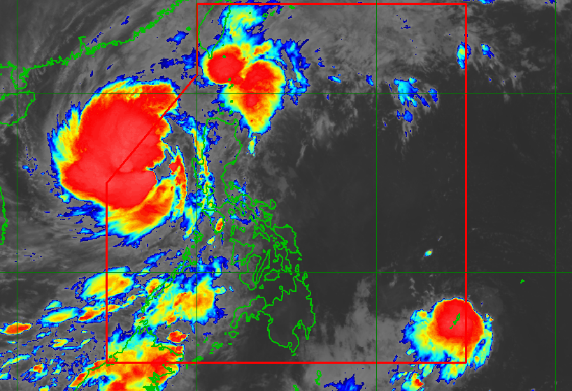
MANILA, Philippines – Tropical Storm Paeng (Nalgae) was moving toward the northwestern boundary of the Philippine Area of Responsibility (PAR) before dawn on Monday, October 31, with its exit expected in the afternoon or evening.
As Paeng prepared to exit, the tropical depression east of northeastern Mindanao entered PAR at 5 am on Monday. It was given the local name Queenie.
The Philippine Atmospheric, Geophysical, and Astronomical Services Administration (PAGASA) said in a briefing past 5 am on Monday that Paeng was already 320 kilometers west northwest of Iba, Zambales, or 340 kilometers west of Dagupan City, Pangasinan.
The tropical storm is now moving west northwest, at the same speed of 10 kilometers per hour (km/h).
It still has maximum sustained winds of 85 km/h and gustiness of up to 105 km/h.
PAGASA said Paeng remains likely to re-intensify into a severe tropical storm within 12 to 24 hours. But it could start weakening late Wednesday, November 2, or on Thursday, November 3.
Rain from Paeng may persist in these areas on Monday morning:
Moderate to heavy rain
- Batanes
- Zambales
- Bataan
- Occidental Mindoro
- Palawan including Calamian and Cuyo Islands
Light to moderate rain, with at times heavy rain
- Ilocos Region
- Cordillera Administrative Region
- Metro Manila
- Calabarzon
- rest of Central Luzon
- rest of Mimaropa
- Babuyan Islands
- Western Visayas
PAGASA said floods and landslides “are likely to slowly subside,” except in areas which saw significant rainfall the past days or those still hit by persistent heavy rain.
The following areas remaining under Signal No. 1 as of 5 am on Monday may still have strong winds from Paeng:
- Ilocos Norte
- Ilocos Sur
- La Union
- Pangasinan
- Apayao
- Kalinga
- Abra
- Mountain Province
- Ifugao
- Benguet
- Nueva Vizcaya
- western part of Cagayan (Santa Praxedes, Claveria, Sanchez Mira, Pamplona, Abulug, Ballesteros, Allacapan, Lasam, Santo Niño, Piat, Tuao, Rizal)
- western part of Isabela (Cordon, Santiago City, San Mateo, Ramon, Alicia, San Isidro, Quezon, Mallig, Roxas, San Manuel, Aurora, Cabatuan)
- northwestern part of Quirino (Cabarroguis, Diffun, Saguday)
- northern, western, and southern parts of Nueva Ecija (Cuyapo, Gapan City, Talavera, San Leonardo, Santo Domingo, Rizal, San Isidro, Zaragoza, Llanera, Guimba, Aliaga, Science City of Muñoz, General Mamerto Natividad, Cabanatuan City, Carranglan, Quezon, San Antonio, San Jose City, Santa Rosa, Lupao, Nampicuan, Talugtug, Peñaranda, Jaen, Licab, Cabiao, Pantabangan)
- Pampanga
- Bataan
- Tarlac
- Zambales
- western part of Bulacan (Hagonoy, Paombong, Malolos City, Guiguinto, Calumpit, Pulilan, Plaridel, Baliuag, Bustos, San Miguel, San Ildefonso, San Rafael)

PAGASA also issued a new gale warning at 5 am on Monday as Paeng continues to affect the country’s coastal waters.
- western seaboards of Northern Luzon and Central Luzon (western coast of Ilocos Norte, Ilocos Sur, La Union, Pangasinan, Zambales, Bataan) – very rough to high seas, waves 4.5 to 7 meters high
- seaboards of Southern Luzon, northern and eastern seaboards of Northern Luzon, eastern seaboard of Central Luzon (Batanes, Cagayan including Babuyan Islands, northern coast of Ilocos Norte, Isabela, Aurora, Pampanga, Bulacan, Metro Manila, Cavite, Batangas, Quezon including Polillo Islands, Occidental Mindoro including Lubang Islands, Oriental Mindoro, Marinduque, Romblon, Palawan including Calamian, Cuyo, Cagayancillo, and Kalayaan Islands) – rough to very rough seas, waves 3.1 to 5.5 meters high
“Rough to high sea conditions are risky for all types of sea vessels. Mariners are advised to remain in port or take shelter in port until winds and waves subside,” the weather bureau said.
Paeng may also cause moderate to rough seas in the western seaboard of the Visayas. Waves could be 1.5 to 3 meters high, which would be risky for small vessels.
Paeng had made landfall five times, all as a severe tropical storm on Saturday, October 29:
- Virac, Catanduanes – 1:10 am
- Caramoan, Camarines Sur – 1:40 am
- Buenavista, Quezon – 6 am
- Santa Cruz, Marinduque – 8:40 am
- Sariaya, Quezon – 1:40 pm
After hitting Quezon for a second time, Paeng crossed Laguna, Cavite, the Metro Manila-Rizal-Bulacan area, Pampanga, and Zambales.
Even before its landfalls in Luzon, Paeng already wreaked havoc in parts of Mindanao and the Visayas. Over 40 people died in Maguindanao del Norte landslides and flooding.
Paeng and Queenie are the Philippines’ 16th and 17th tropical cyclones for 2022, and the fourth and fifth for October, respectively.
PAGASA will issue its first bulletin on Queenie at 11 am on Monday.
But the weather bureau’s 4 am daily forecast showed that Queenie was less than 1,000 kilometers east of northeastern Mindanao, moving west southwest at 15 km/h.
The tropical depression had maximum sustained winds of 45 km/h and gustiness of up to 55 km/h.
More details are expected once the first bulletin on Queenie is released. – Rappler.com
Add a comment
How does this make you feel?


There are no comments yet. Add your comment to start the conversation.