SUMMARY
This is AI generated summarization, which may have errors. For context, always refer to the full article.
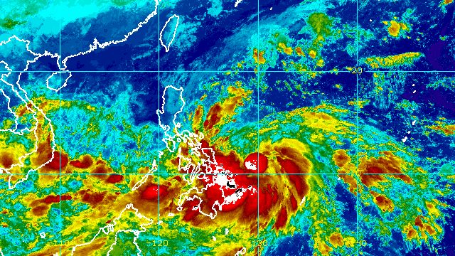
MANILA, Philippines – The weather bureau is now looking at two landfalls for Tropical Storm Paeng (Nalgae) due to the southward shift in its forecast track.
The Philippine Atmospheric, Geophysical, and Astronomical Services Administration (PAGASA) said in a briefing past 11 pm on Thursday, October 27, that Paeng could make its first landfall in or pass very close to Catanduanes on Saturday, October 29.
Then it might make its second landfall in Aurora or Quezon on Sunday, October 30.
As of Thursday evening, Paeng was already 485 kilometers east of Borongan City, Eastern Samar, but it continues to move slowly over the Philippine Sea, heading west.
PAGASA said the tropical storm will move west northwest until Sunday toward Central Luzon or Southern Luzon.
Paeng maintained its strength on Thursday evening, with maximum sustained winds of 65 kilometers per hour and gustiness of up to 80 km/h.
But it is still expected to intensify into a severe tropical storm on Friday, October 28, and into a typhoon by Saturday.
“The occurrence of rapid intensification in the next 72 hours is not ruled out,” PAGASA said.
The weather bureau advised the public to brace for floods and landslides as Paeng starts dumping rain on Friday.
Early Friday morning to evening, October 28
Moderate to heavy rain, with at times intense rain
- Bicol
- Eastern Visayas
Light to moderate rain, with at times heavy rain
- Mimaropa
- Quezon
- Cagayan
- Isabela
- Apayao
- Aurora
- rest of Visayas
- Bangsamoro Autonomous Region in Muslim Mindanao
- Zamboanga Peninsula
- Northern Mindanao
- Caraga
Friday evening, October 28, to Saturday, October 29
Heavy to torrential rain
- Bicol
- Northern Samar
- Marinduque
- Quezon
Moderate to heavy rain, with at times intense rain
- Metro Manila
- rest of Calabarzon
- Aurora
- Bulacan
- Occidental Mindoro
- Oriental Mindoro
- Romblon
- eastern part of Isabela
- eastern part of Cagayan
- rest of Eastern Visayas
- Western Visayas
Light to moderate rain, with at times heavy rain
- Cordillera Administrative Region
- rest of Central Luzon
- rest of Mimaropa
- rest of Cagayan Valley
- rest of Visayas
- Zamboanga Peninsula
- Bangsamoro Autonomous Region in Muslim Mindanao
PAGASA added that areas covered by the rainfall forecast may be updated in its next bulletins “should there be significant shifts in the track and intensity forecast of Paeng.”
Classes have been suspended in some areas for Friday. Several places are already flooded after they saw continuous rain in the past few days from Paeng’s trough or extension and the shear line.

The list of areas under Signal No. 1 was further expanded as of 11 pm on Thursday. Strong winds are expected in these areas:
- Catanduanes
- Albay
- Sorsogon
- Masbate including Ticao and Burias Islands
- Camarines Sur
- eastern part of Romblon (San Fernando, Cajidiocan, Magdiwang, Romblon, Corcuera, Banton)
- Marinduque
- Camarines Norte
- Polillo Islands
- southern part of mainland Quezon (Atimonan, Padre Burgos, Pagbilao, Quezon, Alabat, Perez, Unisan, Gumaca, Plaridel, Agdangan, Macalelon, Pitogo, General Luna, Catanauan, San Francisco, San Andres, Mulanay, San Narciso, Buenavista, Lopez, Calauag, Guinayangan, Tagkawayan, Mauban)
- Eastern Samar
- Northern Samar
- Samar
- Biliran
- northern part of Leyte (San Isidro, Calubian, Tabango, Leyte, Capoocan, Carigara, San Miguel, Babatngon, Tacloban City, Santa Fe, Palo, Villaba, Kananga, Jaro, Alangalang, Pastrana, Dagami, Tanauan, Tabontabon, Tolosa, Tunga, Barugo)
The highest possible wind signal is Signal No. 4 since Paeng is likely to become a typhoon.
Even before the arrival of tropical cyclone winds, however, strong winds due to the surge of the northeast monsoon or hanging amihan have hit parts of Luzon. These areas remain affected on Friday:
- Batanes
- Babuyan Islands
- northern part of mainland Cagayan
- northern part of Apayao
- northern part of Ilocos Norte
- Quezon
- Marinduque
- Romblon
- Bicol
Meanwhile, PAGASA issued a new storm surge advisory at 8 pm on Thursday, warning of a minimal to moderate risk of storm surges up to 2 meters high. Storm surges may cause floods in the “low-lying and exposed coastal areas” of Catanduanes, Albay, Camarines Norte, and Camarines Sur.
The gale warning issued at 5 pm on Thursday also remains in effect. Rough to very rough seas are seen in these seaboards:
- seaboards of Northern Luzon and eastern seaboard of Central Luzon (Batanes, Cagayan including Babuyan Islands, Isabela, Ilocos Norte, Ilocos Sur, Aurora) – waves 2.8 to 5.5 meters high
- eastern seaboards of Southern Luzon and Visayas (Camarines Norte, northern coast of Camarines Sur, Catanduanes, eastern coast of Albay, eastern coast of Sorsogon, northern and eastern coasts of Quezon including Polillo Islands, Northern Samar, Eastern Samar) – waves 2.8 to 4.5 meters high
PAGASA advised fishing boats and other small vessels not to sail, and larger vessels to watch out for big waves. In Bicol and Northern Samar, sea trips have been canceled.
The surge of the northeast monsoon and Paeng may also trigger moderate to rough seas in the eastern seaboard of Mindanao. Waves could be 1.5 to 3.5 meters high, which may be risky for small vessels.
Paeng is the Philippines’ 16th tropical cyclone for 2022 and the fourth for October. PAGASA earlier said there may be up to four tropical cyclones during the month. – Rappler.com
Add a comment
How does this make you feel?


There are no comments yet. Add your comment to start the conversation.