SUMMARY
This is AI generated summarization, which may have errors. For context, always refer to the full article.
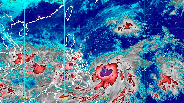
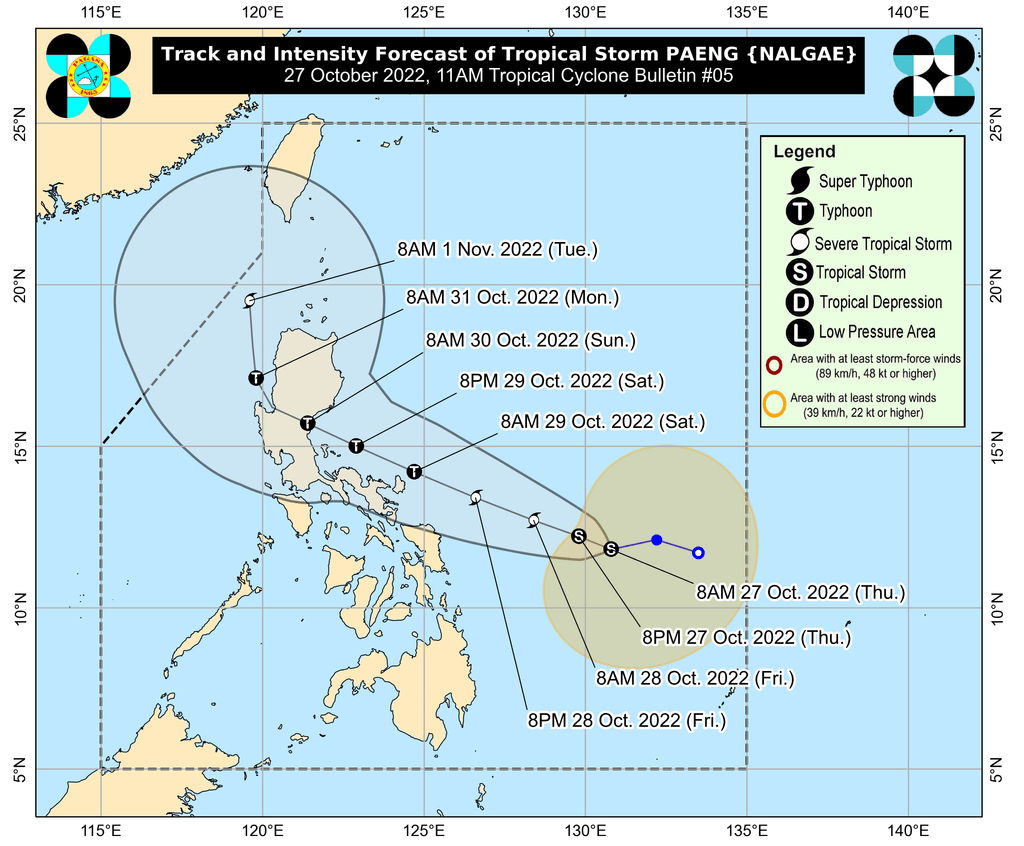
MANILA, Philippines – Paeng intensified from a tropical depression into a tropical storm at 8 am on Thursday, October 27, while moving over the Philippine Sea.
It was given the international name Nalgae, a name contributed by North Korea.
The Philippine Atmospheric, Geophysical, and Astronomical Services Administration (PAGASA) said in a press conference past 11 am on Thursday that Paeng’s maximum sustained winds increased from 55 kilometers per hour to 65 km/h. Its gustiness went up to 80 km/h from the previous 70 km/h.
Paeng is expected to strengthen further as it moves over the warm waters of the Philippine Sea. It may become a severe tropical storm within 24 hours or by Friday, October 28, and a typhoon by Saturday, October 29.
“The occurrence of rapid intensification in the next 72 hours is not ruled out,” PAGASA said.
As of Thursday morning, Paeng was located 540 kilometers east of Borongan City, Eastern Samar, moving west southwest at 10 km/h.
The tropical storm may move west northwest over the Philippine Sea until Sunday, October 30, while heading for Northern Luzon or Central Luzon.
PAGASA said Paeng may first pass close to Catanduanes on Saturday, then make landfall “within any of the coastal areas along the eastern portions of Central Luzon or mainland Cagayan Valley” on Sunday.
But the weather bureau is not ruling out a potential landfall in the eastern portion of Southern Luzon, “considering recent shifts in the forecast track” of Paeng. If its track shifts further southward, it may hit Southern Luzon.
PAGASA Senior Weather Specialist Raymond Ordinario explained that a high pressure area near the southern part of China is influencing Paeng’s movement, causing it to shift toward the south.
While Paeng remains offshore, the trough of the tropical storm and the shear line continue to trigger rain on Thursday, particularly in these areas:
Moderate to heavy rain
- Bicol
- Mimaropa
- Quezon
- Visayas
Light to moderate rain, with at times heavy rain
- Caraga
PAGASA reminded areas affected by Paeng’s trough and the shear line to stay on alert for floods and landslides.
Classes were suspended for some areas on Thursday.
Rain from Paeng – not just its trough – is expected to be felt starting Friday. PAGASA maintained the following rainfall forecast as of 11 am on Thursday:
Early Friday morning to evening, October 28
Moderate to heavy rain, with at times intense rain
- Bicol
- Eastern Visayas
Light to moderate rain, with at times heavy rain
- Mimaropa
- Quezon
- Cagayan
- Isabela
- Apayao
- Aurora
- rest of Visayas
- Bangsamoro Autonomous Region in Muslim Mindanao
- Zamboanga Peninsula
- Northern Mindanao
- Caraga
Friday evening, October 28, to Saturday, October 29
Heavy to torrential rain
- Bicol
- Northern Samar
- Quezon
Moderate to heavy rain, with at times intense rain
- Metro Manila
- rest of Calabarzon
- Aurora
- Bulacan
- Occidental Mindoro
- Oriental Mindoro
- Marinduque
- Romblon
- eastern part of Isabela
- eastern part of Cagayan
- rest of Eastern Visayas
- Western Visayas
Light to moderate rain, with at times heavy rain
- Cordillera Administrative Region
- rest of Central Luzon
- rest of Mimaropa
- rest of Cagayan Valley
- rest of Visayas
- Zamboanga Peninsula
- mainland Bangsamoro Autonomous Region in Muslim Mindanao
PAGASA warned that floods and landslides are expected.
The weather bureau also noted that areas covered by the rainfall forecast may be updated in its next bulletins “should there be significant shifts in the track and intensity forecast of Paeng.”
More areas were placed under Signal No. 1 as of 11 am on Thursday. Strong winds are expected in these areas:
- Catanduanes
- eastern part of Albay (Rapu-Rapu)
- eastern part of Sorsogon (Prieto Diaz, Gubat, Barcelona, Bulusan, Santa Magdalena, Irosin, Juban, Casiguran, Sorsogon City)
- Eastern Samar
- Northern Samar
- Samar
The highest possible wind signal is Signal No. 4 since Paeng is likely to become a typhoon.
Even before the arrival of tropical cyclone winds, however, strong winds due to the surge of the northeast monsoon or hanging amihan have hit parts of Luzon. On Thursday, these areas are affected:
- Batanes
- Babuyan Islands
- northern part of mainland Cagayan
- northern part of Apayao
- northern part of Ilocos Norte
- Quezon
- Marinduque
- Romblon
- Bicol
Meanwhile, the gale warning issued at 5 am on Thursday due to the surge of the northeast monsoon remains in effect. Rough to very rough seas are seen in these seaboards:
- seaboards of Northern Luzon and eastern seaboard of Central Luzon (Batanes, Cagayan including Babuyan Islands, Isabela, Ilocos Norte, Ilocos Sur, Aurora) – waves 2.8 to 5.5 meters high
- eastern seaboards of Southern Luzon and Visayas (Camarines Norte, northern coast of Camarines Sur, Catanduanes, eastern coast of Albay, eastern coast of Sorsogon, coast of northern Quezon including northern and eastern coasts of Polillo Islands, Northern Samar, Eastern Samar) – waves 2.8 to 4.5 meters high
PAGASA advised fishing boats and other small vessels not to sail, and larger vessels to watch out for big waves.
The surge of the northeast monsoon and Paeng may also trigger moderate to rough seas in the eastern seaboard of Mindanao. Waves could be 1.5 to 3.5 meters high, which may be risky for small vessels.
Paeng is the Philippines’ 16th tropical cyclone for 2022 and the fourth for October. PAGASA earlier said there may be up to four tropical cyclones during the month. – Rappler.com
Add a comment
How does this make you feel?


There are no comments yet. Add your comment to start the conversation.