SUMMARY
This is AI generated summarization, which may have errors. For context, always refer to the full article.
Four provinces were placed under Signal No. 2 on Saturday afternoon, April 17, with Typhoon Bising (Surigae) continuing to intensify over the Philippine Sea.
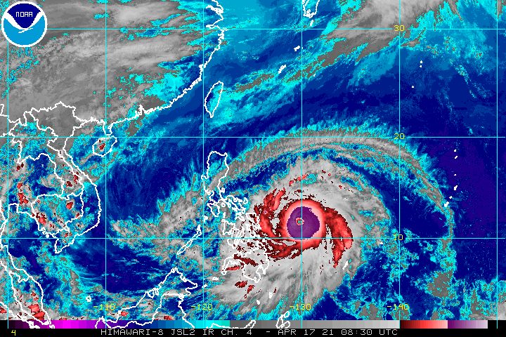
The Philippine Atmospheric, Geophysical, and Astronomical Services Administration (PAGASA) said in its 5 pm bulletin that Bising now has maximum sustained winds of 195 kilometers per hour (km/h) and gustiness of up to 240 km/h.
Earlier on Saturday morning, the typhoon had maximum sustained winds of 185 km/h and gustiness of up to 230 km/h.
PAGASA said Bising is expected to strengthen further and reach its peak intensity of up to 205 km/h on Sunday, April 18, referring to its maximum sustained winds.
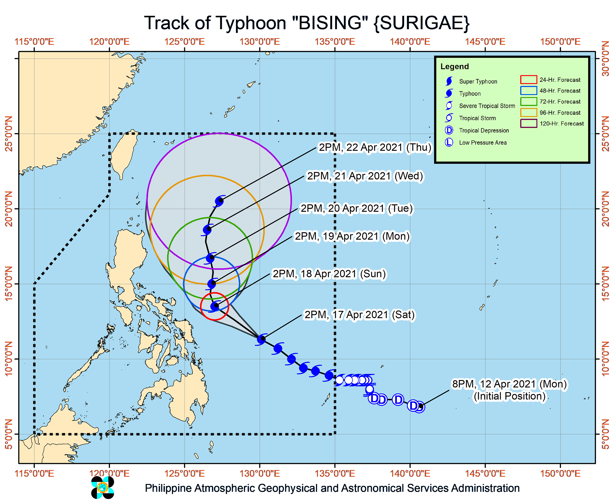
As of Saturday afternoon, Bising was located 460 kilometers east of Guiuan, Eastern Samar. It slightly accelerated, moving west northwest at 25 km/h from the previous 20 km/h.
PAGASA said Bising will move northwest over the Philippine Sea until Sunday afternoon, then slow down and head north until Tuesday afternoon, April 20. After that, it is expected to maintain a north or north northwest track east of Northern Luzon and Central Luzon, still over the sea.
While that would mean landfall is less likely, PAGASA has been warning that Bising could shift west or toward the direction of land, which “may result in potentially significant impacts” in the eastern parts of Southern Luzon and the Visayas.
Below is the complete list of areas under tropical cyclone wind signals as of 5 pm on Saturday.
Signal No. 2 (winds of 61 to 120 km/h)
- Catanduanes
- Northern Samar
- Eastern Samar
- Samar
Signal No. 1 (winds of 30 to 60 km/h)
- Sorsogon
- Albay
- eastern part of Camarines Sur (Calabanga, Naga City, Pili, Bula, Bombon, Magarao, Canaman, Gainza, Camaligan, Milaor, Minalabac, Tinambac, Siruma, Lagonoy, Goa, Tigaon, Ocampo, Baao, Iriga City, Nabua, Balatan, Bato, Buhi, Sagñay, San Jose, Garchitorena, Presentacion, Caramoan, San Fernando)
- eastern part of Masbate (Baleno, Masbate City, Mobo, Uson, Dimasalang, Palanas, Cataingan, Pio V. Corpuz), including Ticao Island
- Biliran
- Leyte
- Southern Leyte
- Camotes Islands
- Dinagat Islands
- Surigao del Norte, including Siargao and Bucas Grande Islands
- Surigao del Sur
PAGASA said tropical cyclone winds that are “at least strong breeze to near gale in strength extend outward up to 400 kilometers” from Bising’s center.
“Destructive typhoon-force winds,” meanwhile, “extend outward up to 90 kilometers” from the center.
The state weather bureau also stressed that Bising may cause floods and landslides when it triggers heavy rain starting Sunday. Here is the latest rainfall forecast for the typhoon:
Sunday, April 18
Moderate to heavy rain, with at times intense rain
- Eastern Visayas
- Bicol
- southern part of Quezon
Monday, April 19
Moderate to heavy rain, with at times intense rain
- Northern Samar
- Bicol
- southern part of Quezon
Meanwhile, travel will be risky for all vessels in the seaboards listed below in the next 24 hours.
Rough to high seas (waves 3 to 10 meters high)
- eastern seaboards of Luzon and areas under tropical cyclone wind signals
Rough to very rough seas (waves 2.8 to 4.5 meters high)
- remaining seaboards of Northern Luzon
- eastern seaboards of Mindanao that are not under tropical cyclone wind signals
Bising is the Philippines’ second tropical cyclone for 2021. The country usually gets an average of 20 tropical cyclones each year. (READ: LIST: PAGASA’s names for tropical cyclones in 2021)
For the next 6 months, PAGASA estimates the following number of tropical cyclones inside the Philippine Area of Responsibility:
- April – 0 or 1
- May – 0 or 1
- June – 1 or 2
- July – 1 to 3
- August – 2 or 3
- September – 2 or 3
– Rappler.com
Add a comment
How does this make you feel?


There are no comments yet. Add your comment to start the conversation.