SUMMARY
This is AI generated summarization, which may have errors. For context, always refer to the full article.
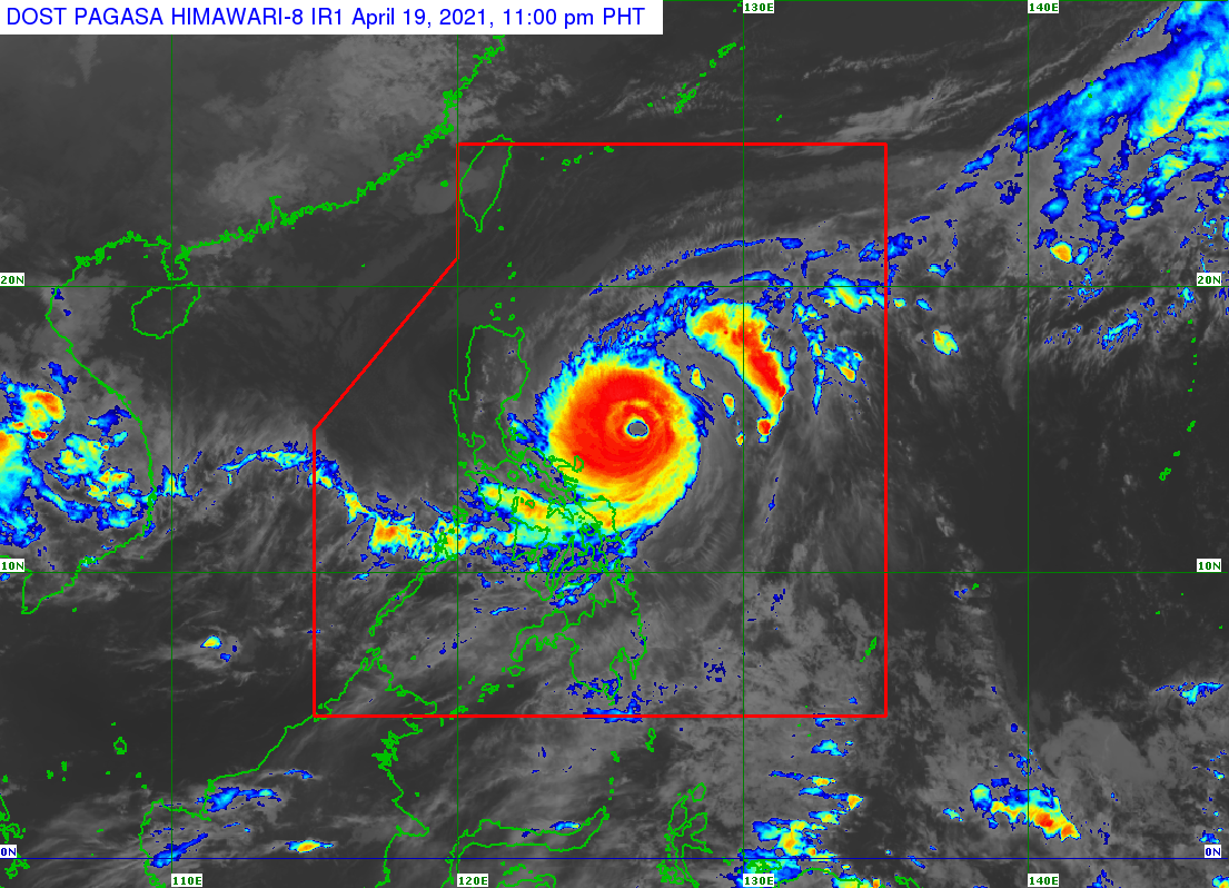
Typhoon Bising (Surigae) slightly weakened over the Philippine Sea on Monday evening, April 19, though it remains a powerful tropical cyclone and warnings are still in place.
Bising’s maximum sustained winds decreased from 195 kilometers per hour (km/h) to 185 km/h, and it now has gustiness of up to 230 km/h from the previous 240 km/h, said the state weather bureau in a bulletin released past 11 pm on Monday.
The Philippine Atmospheric, Geophysical, and Astronomical Services Administration (PAGASA) added that Bising is expected to maintain its intensity in the next 12 to 24 hours, before weakening again.
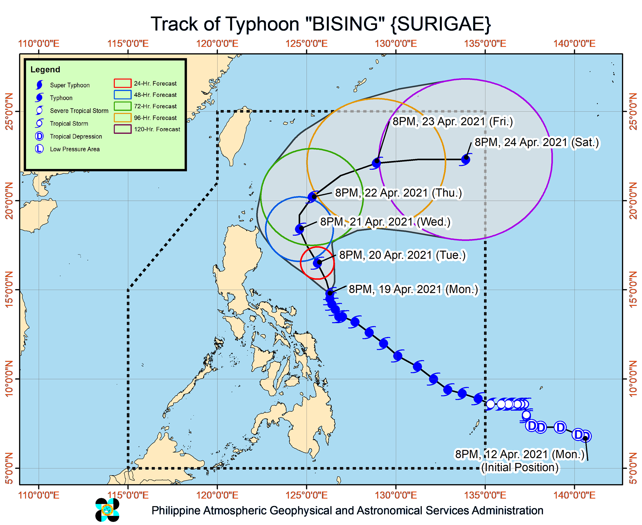
Over the previous 6-hour period, the typhoon had stayed 500 kilometers east of Infanta, Quezon. It has since started moving north at a slow 10 km/h.
With Bising lingering, rain is seen to continue until Tuesday, April 20. There could be more floods and landslides due to the prolonged rainfall.
Moderate to heavy rain, with at times intense rain
- Bicol
- Northern Samar
Tropical cyclone wind signals also remain in effect, covering the areas below as of 11 pm on Monday.
Signal No. 2 (winds of 61 to 120 km/h)
- Catanduanes
- eastern part of Camarines Sur (Sagñay, San Jose, Lagonoy, Garchitorena, Presentacion, Caramoan)
- eastern part of Albay (Tiwi, Malinao, Tabaco City, Malilipot, Bacacay, Rapu-Rapu, Santo Domingo, Legazpi City, Manito)
- northeastern part of Sorsogon (Sorsogon City, Gubat, Barcelona, Prieto Diaz)
- extreme northwestern and eastern parts of Northern Samar (San Roque, Biri, Pambujan, Catubig, Laoang, Gamay, Lapinig, Palapag, Mapanas)
Signal No. 1 (winds of 30 to 60 km/h)
- Batanes
- Cagayan including Babuyan Islands
- Isabela
- Quirino
- Apayao
- eastern part of Kalinga (Pinukpuk, Rizal, Tabuk City)
- extreme eastern part of Mountain Province (Paracelis)
- extreme eastern part of Ifugao (Alfonso Lista)
- northern part of Aurora (Baler, Dipaculao, Dinalungan, Casiguran, Dilasag)
- eastern part of Quezon (Calauag, Guinayangan, Tagkawayan, Buenavista, San Narciso, San Andres) including Polillo Islands
- Camarines Norte
- rest of Camarines Sur
- rest of Albay
- rest of Sorsogon
- Masbate including Burias and Ticao Islands
- rest of Northern Samar
- Samar
- Eastern Samar
- Biliran
- northern part of Leyte (Tabango, San Isidro, Calubian, Leyte, Capoocan, Carigara, Jaro, Pastrana, Palo, Barugo, Tunga, Alangalang, Santa Fe, Tacloban City, San Miguel, Babatngon, Dagami, Tabontabon, Tolosa, Tanauan)
PAGASA said tropical cyclone winds that are “at least strong breeze to near gale in strength extend outward up to 500 kilometers” from Bising’s center.
“Destructive typhoon-force winds,” meanwhile, “extend outward up to 110 kilometers” from the center.
In addition, Bising is still enhancing the northeasterly wind flow, which is bringing strong breeze to near-gale conditions to the rest of Northern Luzon, the rest of Aurora, and the rest of Quezon that are not under any tropical cyclone wind signal. (READ: FAST FACTS: Tropical cyclones, rainfall advisories)
Bising is projected to move north or north northwest until Wednesday evening, April 21, or early Thursday morning, April 22.
After that, the typhoon would head northeast for the rest of Thursday – beginning to veer away from Luzon – and finally east northeast to east on Friday, April 23, and Saturday, April 24.
At that pace, it would exit the Philippine Area of Responsibility (PAR) on Sunday, April 25.
On Tuesday, Bising and the enhanced northeasterly wind flow will continue to have an impact on coastal waters.
Travel is risky for all types of vessels in the following seaboards:
Very rough to high seas (waves 4.5 to 10 meters high)
- northern and eastern seaboards of Luzon
Rough to high seas (waves 3 to 7 meters high)
- northern and eastern seaboards of Eastern Visayas
Small vessels would be at risk in these seaboards and “mariners without the proper experience should immediately seek safe harbor”:
Rough to very rough seas (waves 2.8 to 4.5 meters high)
- northern and western seaboards of Northern Luzon
Rough seas (waves 2.5 to 4 meters high)
- eastern seaboards of Caraga and Davao Oriental
- remaining seaboards of areas under tropical cyclone wind signals
Small vessels and inexperienced mariners should avoid sailing here:
Moderate to rough seas (waves 1.2 to 3 meters high)
- western seaboard of Central Luzon
The Philippine Coast Guard said 3,258 passengers, drivers, and cargo helpers; 43 vessels; and 1,220 rolling cargoes had been stranded in Eastern Visayas, Bicol, Central Visayas, and Northeastern Mindanao as of 4 pm on Monday.
Bising is the Philippines’ second tropical cyclone for 2021. The country usually gets an average of 20 tropical cyclones each year. (READ: LIST: PAGASA’s names for tropical cyclones in 2021)
For the next 6 months, PAGASA estimates the following number of tropical cyclones inside PAR:
- April – 0 or 1
- May – 0 or 1
- June – 1 or 2
- July – 1 to 3
- August – 2 or 3
- September – 2 or 3
– Rappler.com
Add a comment
How does this make you feel?


There are no comments yet. Add your comment to start the conversation.