SUMMARY
This is AI generated summarization, which may have errors. For context, always refer to the full article.
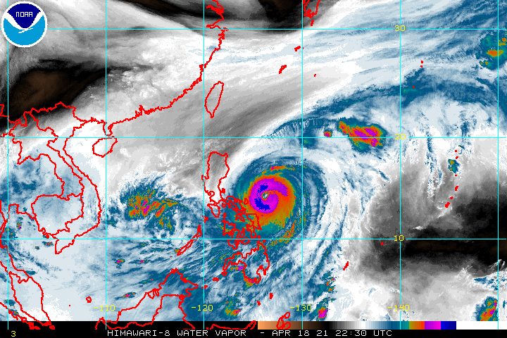
Heavy rain from Typhoon Bising (Surigae) continued to affect Bicol and Eastern Visayas early Monday, April 19, with the tropical cyclone still moving at a slow pace.
The Philippine Atmospheric, Geophysical, and Astronomical Services Administration (PAGASA) said Bising was 250 kilometers east northeast of Virac, Catanduanes, before dawn on Monday.
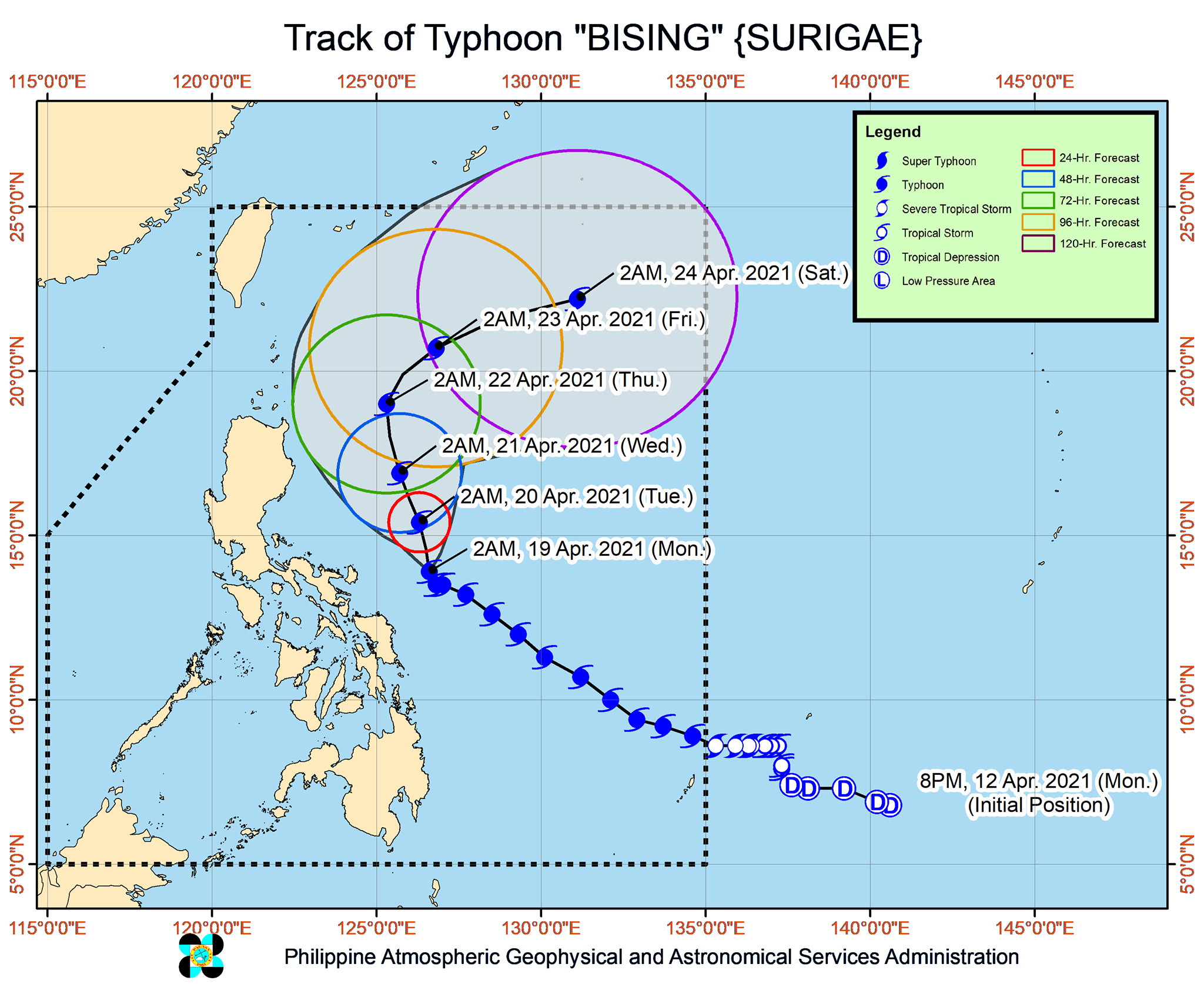
The typhoon is now inching north northwest – from its previous direction of west northwest – at just 10 kilometers per hour (km/h). PAGASA said it is expected to maintain a north or north northwest direction until Wednesday evening, April 21, or early Thursday morning, April 22.
Then Bising would finally turn northeast throughout Thursday and east northeast on Friday, April 23, away from Luzon.
As of early Monday, the typhoon still has maximum sustained winds of 195 km/h and gustiness of up to 240 km/h. It will likely maintain that intensity in the next 12 to 24 hours, said PAGASA, before gradually weakening. (READ: FAST FACTS: Tropical cyclones, rainfall advisories)
The state weather bureau reiterated its rainfall warnings for Bising, saying that floods and landslides “are increasingly likely to occur,” especially because it has been raining since the weekend. Around 50,000 people in Bicol were ordered to preemptively evacuate due to the potential hazards.
Below is PAGASA’s rainfall forecast for the typhoon.
Monday, April 19
Moderate to heavy rain, with at times intense rain
- Bicol
- Northern Samar
- Samar
- Eastern Samar
- Biliran
- Leyte
Tuesday, April 20
Moderate to heavy rain
- Bicol
- Northern Samar
In terms of winds, these are the areas under tropical cyclone wind signals as of 5 am on Monday:
Signal No. 2 (winds of 61 to 120 km/h)
- Catanduanes
- eastern part of Camarines Sur (Garchitorena, Presentacion, Caramoan, Sagñay, San Jose, Lagonoy)
- eastern part of Albay (Tiwi, Malinao, Tabaco City, Malilipot, Santo Domingo, Bacacay, Rapu-Rapu, Legazpi City, Manito)
- eastern and central parts of Sorsogon (Castilla, Sorsogon City, Prieto Diaz, Gubat, Barcelona, Casiguran, Juban, Magallanes, Bulan, Bulusan, Irosin, Santa Magdalena, Matnog)
- Northern Samar
- Samar
- Eastern Samar
- Biliran
Signal No. 1 (winds of 30 to 60 km/h)
- eastern part of Isabela (Divilacan, Palanan, Dinapigue)
- northern part of Aurora (Casiguran, Dilasag)
- southeastern part of Quezon (Guinayangan, Calauag, Tagkawayan) including Polillo Islands
- Camarines Norte
- rest of Camarines Sur
- rest of Albay
- rest of Sorsogon
- Masbate including Burias and Ticao Islands
- Leyte
- Southern Leyte
- northern part of Cebu (Tabogon, Borbon, San Remigio, Bogo City, Medellin, Daanbantayan), including Bantayan and Camotes Islands
- Dinagat Islands
- Siargao and Bucas Grande Islands
PAGASA said tropical cyclone winds that are “at least strong breeze to near gale in strength extend outward up to 440 kilometers” from Bising’s center.
“Destructive typhoon-force winds,” meanwhile, “extend outward up to 110 kilometers” from the center.
PAGASA added that Bising is enhancing the northeasterly wind flow, which will bring strong breeze to near-gale conditions to the following:
- most of Northern Luzon
- Aurora
- remaining parts of Quezon that are not under any tropical cyclone wind signal
Coastal and mountainous areas are more likely to feel the effects of the northeasterly wind flow, according to PAGASA.
Bising and the enhanced northeasterly windflow will also continue to affect coastal waters in the next 24 hours.
Travel is risky for all types of vessels in the following seaboards:
Very rough to very high seas (waves 5 to 12 meters high)
- eastern seaboard of Luzon
Rough to very high seas (waves 2.5 to 7 meters high)
- northern and eastern seaboards of Eastern Visayas
Small vessels would be at risk in these seaboards and “mariners without the proper experience should immediately seek safe harbor”:
Rough to very rough seas
- northern and western seaboards of Northern Luzon (waves 2.5 to 5 meters high)
- eastern seaboard of Caraga (waves 2.5 to 4.5 meters high)
Rough seas (waves 2.5 to 4 meters high)
- remaining seaboards of localities under tropical cyclone wind signals
- eastern seaboard of Davao Oriental
Small vessels and inexperienced mariners should avoid sailing here:
Moderate to rough seas (waves 1.2 to 3 meters high)
- western seaboard of Central Luzon
Bising is the Philippines’ second tropical cyclone for 2021. The country usually gets an average of 20 tropical cyclones each year. (READ: LIST: PAGASA’s names for tropical cyclones in 2021)
For the next 6 months, PAGASA estimates the following number of tropical cyclones inside the Philippine Area of Responsibility:
- April – 0 or 1
- May – 0 or 1
- June – 1 or 2
- July – 1 to 3
- August – 2 or 3
- September – 2 or 3
– Rappler.com
Add a comment
How does this make you feel?


There are no comments yet. Add your comment to start the conversation.