SUMMARY
This is AI generated summarization, which may have errors. For context, always refer to the full article.
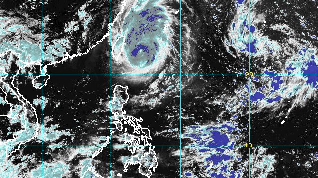
MANILA, Philippines – Typhoon Inday (Muifa) started moving away from the Philippines at just 10 kilometers per hour (km/h) on Sunday afternoon, September 11.
The typhoon was located 360 kilometers northeast of Itbayat, Batanes, heading north northwest, the Philippine Atmospheric, Geophysical, and Astronomical Services Administration (PAGASA) said in its 5 pm bulletin on Sunday.
After gradually intensifying since Saturday, September 10, Inday had maximum sustained winds of 165 km/h and gustiness of up to 205 km/h as of Sunday afternoon.
PAGASA said gusty conditions may be experienced in extreme Northern Luzon on Monday, September 12, “due to the channeling of the typhoon circulation in the Luzon Strait.”
So far, tropical cyclone wind signals have not been raised due to Inday.
The weather bureau added that the typhoon remains “less likely” to bring heavy rain to the country.
But its outermost rainbands may trigger scattered rain showers and thunderstorms in the province of Batanes.
The southwest monsoon or hanging habagat, weaker on Sunday compared to Saturday, may also cause isolated rain in the western parts of Central Luzon and Southern Luzon.
Meanwhile, PAGASA issued a gale warning for the seaboards of Batanes and Babuyan Islands at 5 pm on Sunday. Seas are rough, with waves 2.8 to 4 meters high.
The weather bureau advised fishing boats and other small vessels not to sail, and larger vessels to watch out for big waves.
Moderate to rough seas may also be seen in the eastern seaboard and the rest of the northern seaboard of Northern Luzon, with waves 1.2 to 3 meters high. Conditions could be risky for small vessels.
PAGASA expects Inday to slowly move north northwest in the next 12 hours, or until early Monday, before turning north toward Japan’s Yaeyama Islands.
The typhoon could still intensify until Monday morning, but may start weakening late Monday or on Tuesday, September 13, due to “the slightly cooler waters east of Taiwan.”
Inday’s projected exit from the Philippine Area of Responsibility (PAR) is on Tuesday morning or afternoon.

Inday is the Philippines’ ninth tropical cyclone for 2022 and the first for September.
PAGASA also announced that it is monitoring a low pressure area (LPA) outside PAR, which may develop into a tropical depression within three days.
As of Sunday afternoon, the LPA was 2,045 kilometers east northeast of extreme Northern Luzon.
The weather bureau said the potential tropical cyclone, if enters PAR, may only stay near the PAR northeastern boundary.
The next tropical cyclone name on PAGASA’s list is Josie.
PAGASA expects 7 to 11 tropical cyclones to enter or develop inside PAR from September 2022 to February 2023. Per month, these are the weather bureau’s estimates:
- September 2022 – 2 or 3
- October 2022 – 2 to 4
- November 2022 – 2 or 3
- December 2022 – 1 or 2
- January 2023 – 0 or 1
- February 2023 – 0 or 1
– Rappler.com
Add a comment
How does this make you feel?


There are no comments yet. Add your comment to start the conversation.