SUMMARY
This is AI generated summarization, which may have errors. For context, always refer to the full article.
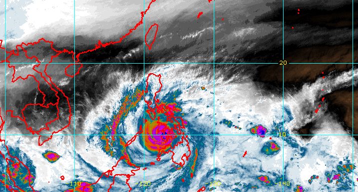
MANILA, Philippines – Typhoon Odette (Rai) had already made landfall at least seven times on Thursday, December 16, with its fifth and sixth landfalls in Bohol and its seventh in Cebu.
The Philippine Atmospheric, Geophysical, and Astronomical Services Administration (PAGASA) said in its 11 pm bulletin on Thursday that Odette was in the vicinity of Carcar, Cebu, where it made its most recent landfall.
These are the seven areas:
- Siargao Island, Surigao del Norte – 1:30 pm
- Cagdianao, Dinagat Islands – 3:10 pm
- Liloan, Southern Leyte – 4:50 pm
- Padre Burgos, Southern Leyte – 5:40 pm
- President Carlos P. Garcia, Bohol – 6:30 pm
- Bien Unido, Bohol – 7:30 pm
- Carcar, Cebu – 10 pm
The typhoon accelerated late Thursday evening, moving west at 35 kilometers per hour from the previous 30 km/h.
From a peak intensity of 195 km/h in the afternoon, Odette has also weakened, though it remains a powerful typhoon. Its maximum sustained winds were down to 175 km/h as of 11 pm on Thursday, with gustiness of up to 240 km/h.
Tropical cyclone wind signals remain in effect, with Signal No. 4 still the highest.
Signal No. 4 (very destructive typhoon-force winds)
- western part of Bohol (Balilihan, Catigbian, Loon, San Isidro, Antequera, Maribojoc, Cortes, Clarin, Calape, Tubigon, Sagbayan, Danao, Inabanga, Getafe, Buenavista, Talibon, Trinidad, Bien Unido)
- central and southern parts of Cebu (Lapu-Lapu City, Cordova, Cebu City, Mandaue City, Consolacion, Liloan, Toledo City, Talisay City, Minglanilla, Naga City, Pinamungahan, San Fernando, Carcar City, Aloguinsan, Barili, Sibonga, Dumanjug, Ronda, Argao, Alcantara, Moalboal, Badian, Dalaguete, Alcoy, Alegria, Malabuyoc, Boljoon, Oslob, Ginatilan, Samboan, Santander)
- northern and central parts of Negros Oriental (Canlaon City, Vallehermoso, Guihulngan City, La Libertad, Jimalalud, Tayasan, Ayungon, Bindoy, Manjuyod, Mabinay, Bayawan City, Basay, Bais City, Pamplona, San Jose, Tanjay City, Amlan)
- central and southern parts of Negros Occidental (La Castellana, Pontevedra, Hinigaran, Moises Padilla, Isabela, Binalbagan, Himamaylan City, Kabankalan City, Ilog, Cauayan, Candoni, Sipalay City, Hinoba-an)
Signal No. 3 (destructive typhoon-force winds)
- northern part of Palawan (El Nido, Taytay, Araceli, Dumaran, Roxas, San Vicente) including Cagayancillo and Cuyo Islands
- southwestern part of Leyte (Bato, Matalom, Hilongos, Hindang, Baybay City, Inopacan)
- western part of Southern Leyte (Padre Burgos, Tomas Oppus, Macrohon, Maasin City, Limasawa, Malitbog, Bontoc)
- northern part of Cebu (Tuburan, Catmon, Carmen, Danao City, Asturias, Balamban, Dalaguete, Sogod) including Camotes Islands
- rest of Bohol
- rest of Negros Oriental
- Siquijor
- northern part of Negros Occidental (Calatrava, San Carlos City, Salvador Benedicto, Talisay City, Silay City, Bacolod City, Murcia, Bago City, Valladolid, Pulupandan, La Carlota City, San Enrique)
- Guimaras
- southern part of Iloilo (Iloilo City, Pavia, Leganes, Santa Barbara, San Miguel, Alimodian, Oton, Leon, Tigbauan, Tubungan, Igbaras, Guimbal, Miagao, San Joaquin, Dumangas, Zarraga, New Lucena, Cabatuan, Maasin)
- southern part of Antique (San Remigio, Patnongon, Belison, San Jose, Sibalom, Hamtic, Tobias Fornier, Anini-y)
Signal No. 2 (damaging gale- to storm-force winds)
- Albay
- Sorsogon
- Masbate including Ticao and Burias Islands
- Romblon
- Oriental Mindoro
- Occidental Mindoro
- rest of Palawan including Calamian and Kalayaan Islands
- Northern Samar
- Eastern Samar
- Samar
- Biliran
- rest of Leyte
- rest of Southern Leyte
- rest of Cebu including Bantayan Islands
- rest of Negros Occidental
- rest of Iloilo
- Capiz
- Aklan
- rest of Antique
- Dinagat Islands
- Surigao del Norte
- northern part of Surigao del Sur (Lanuza, Carmen, Madrid, Cantilan, Carrascal, San Miguel, Cortes, Tandag City)
- Agusan del Norte
- northern part of Agusan del Sur (Esperanza, Sibagat, San Luis, Bayugan City)
- Misamis Oriental
- Camiguin
- northern part of Bukidnon (Talakag, Impasug-ong, Baungon, Sumilao, Manolo Fortich, Malitbog, Libona)
- Lanao del Norte
- Misamis Occidental
- extreme northern part of Zamboanga del Norte (Dapitan City, Siayan, Sindangan, Jose Dalman, Manukan, President Manuel A. Roxas, Katipunan, Sergio Osmeña Sr., Polanco, Dipolog City, Piñan, Mutia, La Libertad, Rizal, Sibutad)
Signal No. 1 (strong winds)
- Catanduanes
- Camarines Norte
- Camarines Sur
- Marinduque
- southern part of Quezon (San Antonio, Tiaong, Candelaria, Sariaya, Dolores, Lucena City, Pagbilao, Padre Burgos, Atimonan, Agdangan, Unisan, Gumaca, Plaridel, Pitogo, Lopez, Guinayangan, Buenavista, Catanauan, General Luna, Macalelon, Mulanay, San Narciso, San Andres, San Francisco, Tagkawayan, Calauag, Quezon, Alabat, Tayabas City, Perez)
- Batangas
- rest of Surigao del Sur
- rest of Agusan del Sur
- rest of Bukidnon
- Lanao del Sur
- rest of northern part of Zamboanga del Norte (Labason, Kalawit, Tampilisan, Liloy, Salug, Godod, Bacungan, Gutalac, Baliguian)
- rest of northern part of Zamboanga del Sur (Bayog, Lakewood, Kumalarang, Guipos, Dumalinao, Tukuran, Ramon Magsaysay, Aurora, Sominot, Tigbao, Labangan, Pagadian City, Midsalip)
- northern part of Zamboanga Sibugay (Titay, Ipil, Naga, Kabasalan, Siay, Diplahan, Buug)
Meanwhile, PAGASA updated its rainfall forecast for the typhoon, with torrential rain now concentrated in parts of the Visayas after the initial onslaught in Mindanao.
Thursday evening, December 16, until early Friday morning, December 17
- Heavy to torrential rain – Central Visayas, Western Visayas
- Moderate to heavy rain, with at times intense rain – Eastern Visayas, Zamboanga del Norte, Lanao del Norte, Palawan, Bicol
- Light to moderate rain, with at times heavy rain – Quezon, rest of Mimaropa, rest of Mindanao
Early Friday morning, December 17, until early Saturday morning, December 18
- Heavy to intense rain, with at times torrential rain – Western Visayas, Palawan including Calamian, Cuyo, and Cagayancillo Islands
- Moderate to heavy rain, with at times intense rain – rest of Visayas, Bicol, Zamboanga Peninsula, Calabarzon, rest of Mimaropa
- Light to moderate rain, with at times heavy rain – Caraga, southern part of Aurora, rest of Northern Mindanao
Early Saturday morning, December 18, until early Sunday morning, December 19
- Heavy to intense rain, with at times torrential rain – Kalayaan Islands
- Light to moderate rain, with at times heavy rain – Cagayan Valley, Aurora, Quezon, mainland Palawan, Calamian Islands
The weather bureau also said there is a “moderate to high risk” of storm surges up to 3 meters high on Friday, December 17. Storm surges “may cause life-threatening flooding in the low-lying coastal areas of Central Visayas, Iloilo, Antique, Guimaras, Negros Occidental, and several localities in the northern portion of Palawan, including Calamian, Cuyo, and Cagayancillo Islands.”

On Friday, moderate to very high seas will persist in the seaboards of areas under tropical cyclone wind signals. Waves will be 1.2 to 10 meters high, making travel risky for all vessels.
Another gale warning was issued due to Odette and the northeast monsoon or hanging amihan as well. This gale warning covers coastal waters not under any wind signal in the seaboards of Northern Luzon and in the eastern seaboards of Central Luzon, Southern Luzon, and Davao Oriental. Waters are rough to very rough, with waves 2.8 to 4.5 meters high.
The remaining seaboards of the Philippines not under any wind signal will continue to have moderate to rough seas on Friday. Waves will still be 1.2 to 3.1 meters high and conditions remain risky for small vessels.
After its first seven landfalls, Odette will cross Negros Island, pass over the Panay Gulf close to Guimaras, and pass over the southwestern coast of Panay Island before emerging over the Sulu Sea on Friday morning.
Then the typhoon could pass near or in the vicinity of Cuyo or Cagayancillo and cross the northern or central part of Palawan on Friday afternoon before emerging over the West Philippine Sea.
Finally, Odette may pass the vicinity of Kalayaan Islands on Saturday, December 18.
PAGASA added that Odette could slightly weaken further as it crosses the western part of Visayas and mainland Palawan, but will remain a typhoon.
Once over the West Philippine Sea, Odette is likely to reintensify. But weakening could resume on Sunday, December 19, as the typhoon “becomes exposed to increasing vertical wind shear and the surge of the northeast monsoon.”
By that time, it would already be outside the Philippine Area of Responsibility. Odette could exit PAR on Saturday, possibly late morning or early afternoon.
Odette is the Philippines’ 15th tropical cyclone for 2021. Around 20 form within or enter PAR each year.
Here are PAGASA’s estimates for tropical cyclones in the coming months:
- December 2021 – 1 or 2
- January 2022 – 0 or 1
- February 2022 – 0 or 1
- March 2022 – 0 or 1
- April 2022 – 0 or 1
- May 2022 – 1 or 2
– Rappler.com
Add a comment
How does this make you feel?


There are no comments yet. Add your comment to start the conversation.