SUMMARY
This is AI generated summarization, which may have errors. For context, always refer to the full article.
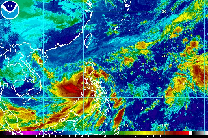
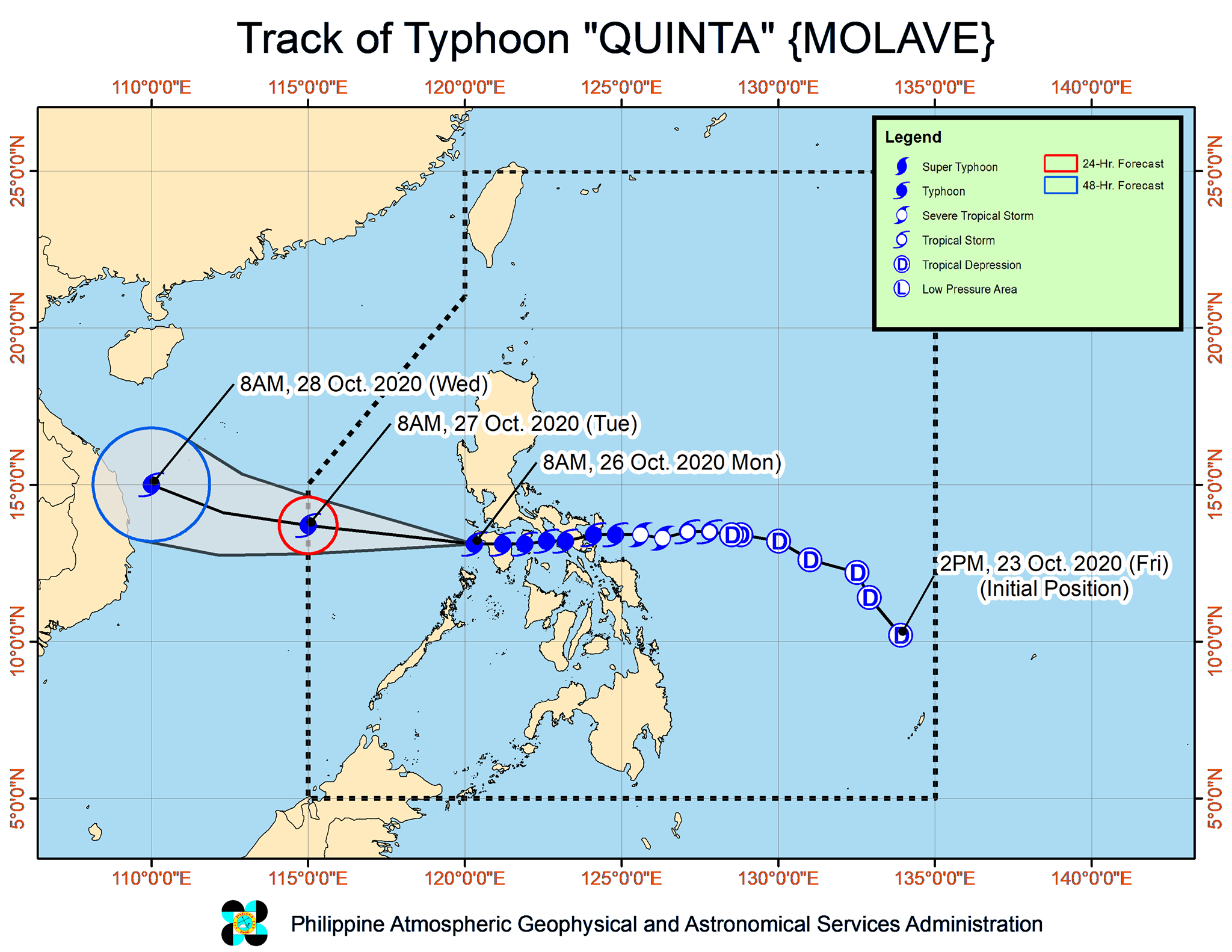
Typhoon Quinta (Molave) moved over the Mindoro Strait late Monday morning, October 26, leaving the landmass of Luzon, where it made landfall 5 times.
The Philippine Atmospheric, Geophysical, and Astronomical Services Administration (PAGASA) said in its 11 am bulletin on Monday that Quinta is now 125 kilometers north of Coron, Palawan, or 120 kilometers west southwest of Calapan City, Oriental Mindoro.
The typhoon is still moving west at 25 kilometers per hour (km/h), a direction it will maintain until Monday afternoon, according to PAGASA. Afterwards, it will turn west northwest toward the western boundary of the Philippine Area of Responsibility (PAR), where it will exit on Tuesday morning, October 27.
So far, Quinta has maintained its strength, with maximum sustained winds of 125 km/h and gustiness of up to 150 km/h. But now that the typhoon is over water, PAGASA said it is forecast to re-intensify and may reach its peak intensity within 24 to 48 hours. (READ: FAST FACTS: Tropical cyclones, rainfall advisories)
Several areas remain under tropical cyclone wind signals as of 11 am on Monday. Most have been removed from the list or downgraded.
Signal No. 3
- northwestern part of Occidental Mindoro (Abra de Ilog, Mamburao, Paluan) including Lubang Island
Signal No. 2
- Oriental Mindoro
- rest of Occidental Mindoro
- Calamian Islands
- Batangas
- extreme northern part of Antique (Caluya)
Signal No. 1
- southern part of Zambales (San Antonio, Castillejos, Subic, Olongapo City)
- Bataan
- southwestern part of Pampanga (Floridablanca, Lubao, Sasmuan, Masantol)
- southwestern part of Bulacan (Hagonoy, Paombong, Malolos City, Bulacan, Obando, Meycauayan City)
- Metro Manila
- Rizal
- Cavite
- Laguna
- Quezon including Polillo Island
- Marinduque
- Romblon
- northern part of Palawan (El Nido, Taytay) including Cuyo Islands
- Aklan
- rest of northern part of Antique (Laua-an, Barbaza, Tibiao, Culasi, Sebaste, Pandan, Libertad)
Destructive typhoon-force winds will persist in the northwestern part of Occidental Mindoro, the lone area left under Signal No. 3, while damaging gale to storm-force winds will be felt in areas under Signal No. 2 and strong breeze to near gale conditions in areas under Signal No. 1.
Strong breeze to gale conditions from a northeasterly surge will also continue in these areas:
- Ilocos Region
- Batanes
- Cagayan
- Apayao
- northern part of Zambales
In terms of rainfall, Quinta and the tail-end of a frontal system will be bringing more rain for the rest of Monday. Affected areas remain at risk of floods and landslides.
Moderate to heavy rain, with at times intense rain (Quinta)
- Occidental Mindoro
- Oriental Mindoro
- Romblon
- Marinduque
- northern part of Palawan including Calamian and Cuyo Islands
- Calabarzon
- Aurora
- Isabela
- Quirino
- Mountain Province
- Ifugao
- Benguet
- Aklan
- Capiz
- Antique
Moderate to heavy rain (tail-end of a frontal system)
- Cagayan
- Apayao
- Kalinga
- Abra
- Ilocos Norte
- Ilocos Sur
Light to moderate rain, with at times heavy rain (Quinta and tail-end of a frontal system)
- rest of Luzon
- Western Visayas
- Zamboanga Peninsula
- Bangsamoro Autonomous Region in Muslim Mindanao
- Northern Mindanao
- Caraga
Quinta earlier made landfall in the country 5 times.
- San Miguel Island, Tabaco City, Albay – 6:10 pm, Sunday, October 25
- Malinao, Albay – 6:50 pm, Sunday
- San Andres, Quezon – 10:30 pm, Sunday
- Torrijos, Marinduque – 1:20 am, Monday, October 26
- Pola, Oriental Mindoro – 3:30 am, Monday
PAGASA no longer issued a warning for potential storm surges late Monday morning. But it warned that travel is still risky for all types of sea vessels in these waters:
Rough to high seas
- areas under Signal Nos. 1, 2, and 3 (waves 2.5 to 7 meters high)
Rough to very rough seas
- remaining seaboards of Luzon (waves 2.5 to 5 meters high)
- western, northern, and eastern seaboards of Visayas (waves 2.5 to 5 meters high)
Elsewhere in the country, those with small vessels should take precautionary measures, while “inexperienced mariners” should avoid sailing at this time, said PAGASA.
Moderate to rough seas
- other seaboards of the Philippines (waves 1.2 to 3.1 meters high)
Meanwhile, PAGASA has just spotted a new low pressure area (LPA) outside PAR, at 1,920 kilometers east of Southern Luzon.
The state weather bureau said the LPA may enter PAR on Wednesday, October 28, or Thursday morning, October 29.
So far, it is “less likely” to develop into a tropical depression, at least in the next 48 hours.
Quinta is the Philippines’ 17th tropical cyclone for 2020, and the 4th for October.
An average of 20 tropical cyclones form within or enter PAR each year. (READ: LIST: PAGASA’s names for tropical cyclones in 2020)
These are PAGASA’s latest estimates for the number of tropical cyclones inside PAR in the next 6 months:
- November 2020 – 1 to 3
- December 2020 – 2 or 3
- January 2021 – 0 or 1
- February 2021 – 0 or 1
- March 2021 – 0 or 1
- April 2021 – 0 or 1
Last October 2, the state weather bureau warned Filipinos to expect more rain in the coming months due to the onset of La Niña. – Rappler.com
Add a comment
How does this make you feel?


There are no comments yet. Add your comment to start the conversation.