SUMMARY
This is AI generated summarization, which may have errors. For context, always refer to the full article.
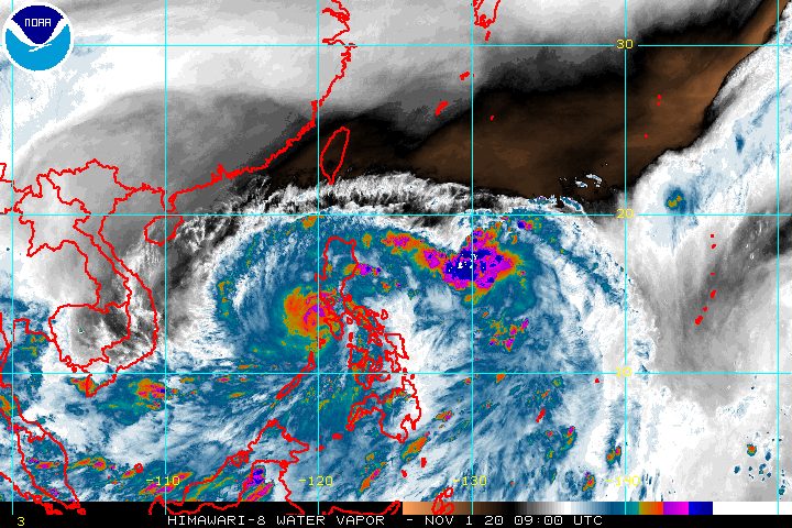
The center of Typhoon Rolly (Goni) was moving toward Batangas and Cavite late Sunday afternoon, November 1, with the two provinces told to brace for “destructive winds and intense rainfall” in the coming hours.
In its 5 pm bulletin on Sunday, the Philippine Atmospheric, Geophysical, and Astronomical Services Administration (PAGASA) said Rolly is already 50 kilometers south southwest of Tayabas, Quezon, still moving west at 25 kilometers per hour (km/h).
Between 5 pm and 7 pm, the center of Rolly’s eye will be located 70 kilometers south of Metro Manila, the closest it will be to the capital region.
The typhoon continues to gradually weaken. Its maximum sustained winds are down to 165 km/h from the previous 175 km/h, while its gustiness also decreased to 230 km/h from the previous 240 km/h. (READ: FAST FACTS: Tropical cyclones, rainfall advisories)
There are no more areas under Signal No. 4, but many remain under Signal Nos. 1, 2, and 3. Below is the latest list as of 5 pm on Sunday.
Signal No. 3 (destructive typhoon-force winds)
- southern part of Zambales (San Marcelino, San Narciso, Subic, Olongapo City, Castillejos, San Antonio)
- Bataan
- southern part of Pampanga (Floridablanca, Guagua, Minalin, Apalit, Macabebe, Masantol, Sasmuan, Lubao)
- southern part of Bulacan (Baliuag, Bustos, Angat, Norzagaray, San Jose del Monte City, Santa Maria, Pandi, Plaridel, Pulilan, Calumpit, Malolos City, Guiguinto, Balagtas, Bocaue, Marilao, Meycauayan City, Obando, Bulacan, Paombong, Hagonoy)
- Rizal
- Quezon including Polillo Island
- Metro Manila
- Cavite
- Laguna
- Batangas
- Marinduque
- northwestern part of Occidental Mindoro (Santa Cruz, Mamburao, Paluan, Abra de Ilog) including Lubang Island
- northern part of Oriental Mindoro (Puerto Galera, San Teodoro, Baco, Calapan City, Naujan, Victoria, Naujan Lake, Pola, Socorro)
Signal No. 2 (damaging gale- to storm-force winds)
- rest of Zambales
- rest of Pampanga
- rest of Bulacan
- southern portion of Tarlac (Concepcion, Capas, Bamban)
- rest of Occidental Mindoro
- rest of Oriental Mindoro
- southern part of Nueva Ecija (General Tinio, Gapan City, Peñaranda, San Leonardo, Jaen, San Isidro, Cabiao, San Antonio)
Signal No. 1 (strong breeze to near gale conditions)
- mainland Cagayan
- Isabela
- Apayao
- Kalinga
- Mountain Province
- Ifugao
- Abra
- Ilocos Norte
- Ilocos Sur
- La Union
- Benguet
- Nueva Vizcaya
- Quirino
- rest of Aurora
- rest of Nueva Ecija
- rest of Tarlac
- Camarines Sur
- Camarines Norte
- Burias Island
- Romblon
- Calamian Islands
PAGASA added that strong breeze to near gale conditions due to the northeasterlies will be experienced over the rest of Northern Luzon that are not under Signal No. 1.
Rolly will also trigger more rain in parts of Luzon and a few areas in the Visayas and Mindanao on Sunday evening.
Heavy to at times intense rain
- Calabarzon
- Metro Manila
- Marinduque
- Romblon
- Oriental Mindoro
- Occidental Mindoro
- Bataan
- Bulacan
- Aurora
- eastern parts of mainland Cagayan and of Isabela
Moderate to heavy rain
- Cordillera Administrative Region
- rest of Central Luzon
- rest of mainland Cagayan Valley
Light to moderate rain, with at times heavy rain
- rest of Luzon
- Western Visayas
- Zamboanga Peninsula
- Bangsamoro Autonomous Region in Muslim Mindanao
There is still a high risk of storm surges in the next 24 hours. These storm surges, “which may be accompanied by swells and breaking waves reaching the coast, can cause life-threatening and damaging coastal inundation.”
Up to 3 meters high
- northern coastal areas of Quezon including Polillo Island
- coastal areas of Metro Manila, Cavite, Bulacan, Pampanga, Bataan
- southeastern coastal area of Batangas, facing Tayabas Bay
- most of the southern coastal areas of Quezon
Up to 2 meters high
- coastal areas of Marinduque, Lubang Island, Albay, Masbate including Ticao and Burias Islands
- northern coastal area of Occidental Mindoro and Oriental Mindoro
- remaining coastal areas of Quezon and Batangas
PAGASA also said there is a moderate to high risk of storm surges in the coastal areas surrounding Laguna de Bay and Taal Lake.
Travel remains risky for all types of vessels in:
- seaboards of areas under tropical cyclone wind signals – rough to phenomenal seas, with waves 2.5 to 16 meters high
- remaining seaboards of Northern Luzon as well as eastern seaboards of Eastern Visayas that are not under a tropical cyclone wind signal and Caraga – rough to very rough seas, with waves 2.5 to 5 meters high
In the remaining seaboards of the country, there are moderate to rough seas, with waves 1.2 to 2.5 meters high. PAGASA advised those using small vessels to take precautionary measures, while “inexperienced mariners should avoid navigating in these conditions.”
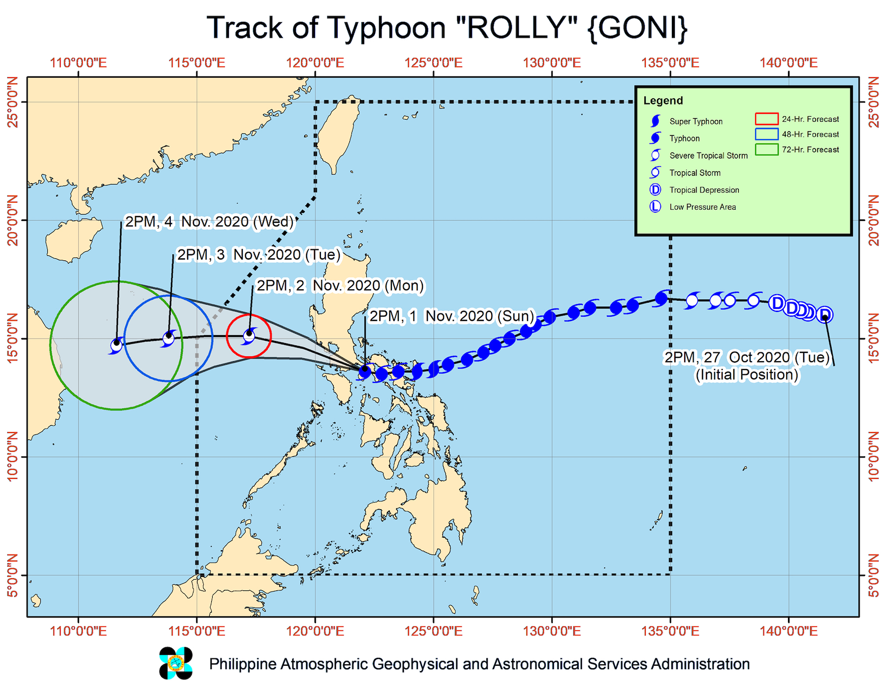
Rolly had made landfall thrice in the Philippines on Sunday, with at least 4 people reported dead following its onslaught. Its first two landfalls were as a super typhoon, while its third was as a typhoon.
- Bato, Catanduanes – 4:50 am
- Tiwi, Albay – 7:20 am
- San Narciso, Quezon – 12 pm
Rolly is forecast to exit mainland Luzon landmass and emerge over the West Philippine Sea on Sunday night, weaker though still classified as a typhoon.
It could leave the Philippine Area of Responsibility (PAR) on Tuesday morning, November 3.
Meanwhile, Tropical Storm Siony (Atsani) was located 1,140 kilometers east of Central Luzon as of Sunday afternoon.
It continues to move west northwest at a relatively fast 30 km/h.
The tropical storm also maintained its strength, with maximum sustained winds of 75 km/h and gustiness of up to 90 km/h.
Siony is not seen to have any effect on the country, at least for the next 2 to 3 days.
Rolly is the Philippines’ 18th tropical cyclone for 2020, while Siony is the 19th.
An average of 20 tropical cyclones form within or enter PAR each year.
These are PAGASA’s latest estimates for the number of tropical cyclones inside PAR in the next 6 months:
- November 2020 – 1 to 3
- December 2020 – 2 or 3
- January 2021 – 0 or 1
- February 2021 – 0 or 1
- March 2021 – 0 or 1
- April 2021 – 0 or 1
Last October 2, the state weather bureau warned Filipinos to expect more rain in the coming months due to the onset of La Niña. – Rappler.com
Add a comment
How does this make you feel?


There are no comments yet. Add your comment to start the conversation.