SUMMARY
This is AI generated summarization, which may have errors. For context, always refer to the full article.
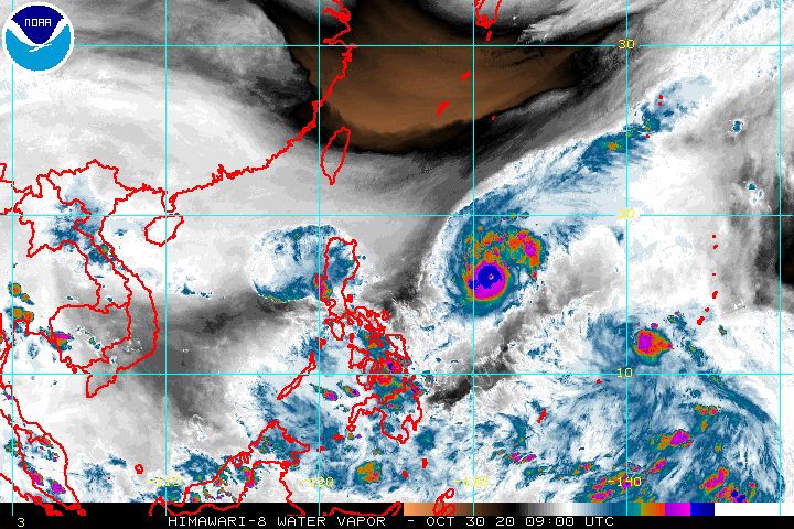
Typhoon Rolly (Goni) intensified further over the Philippine Sea on Friday afternoon, October 30, becoming an even more powerful tropical cyclone.
In a bulletin released past 5 pm on Friday, the Philippine Atmospheric, Geophysical, and Astronomical Services Administration (PAGASA) said Rolly now has maximum sustained winds of 185 kilometers per hour (km/h) and gustiness of up to 230 km/h.
It previously had maximum sustained winds of 165 km/h and gustiness of up to 205 km/h on Friday morning, or 6 hours earlier.
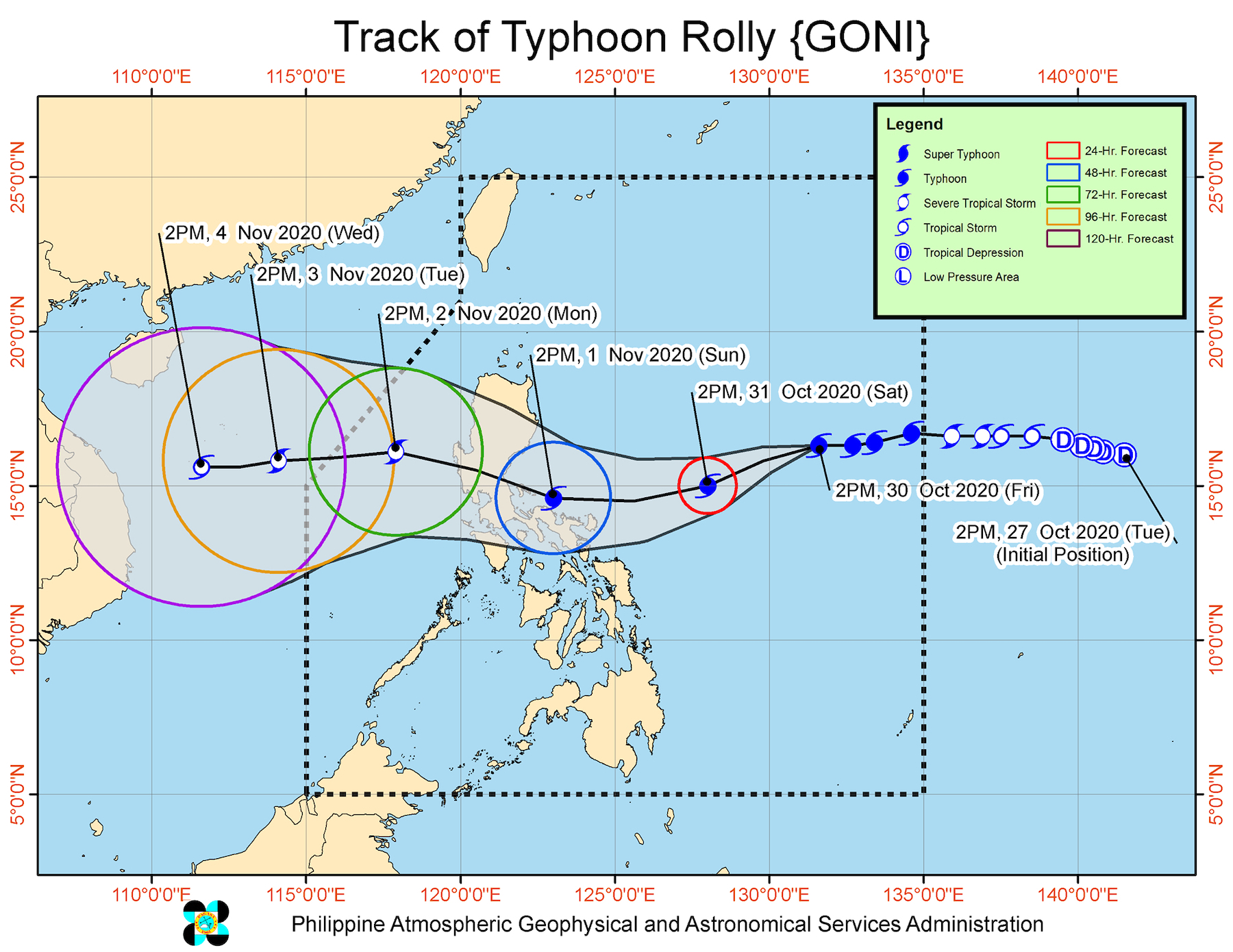
PAGASA warned that the typhoon is not yet done intensifying as it remains over water, and could hit land with maximum sustained winds of 175 to 195 km/h. (READ: FAST FACTS: Tropical cyclones, rainfall advisories)
As of Friday afternoon, Rolly was already 980 kilometers east of Casiguran, Aurora, moving west at a slightly faster 20 km/h from the previous 15 km/h.
By Sunday morning, November 1, the typhoon is seen to be off the coast of Bicol. Then it will turn and start moving toward the eastern coast of the Aurora-Quezon area, where it could make landfall on Sunday evening or early Monday morning, November 2.
Since Rolly will first come near the coast of Bicol, the province of Catanduanes is now under Signal No. 1. “Strong breeze to near gale conditions” are expected in Catanduanes within 36 hours.
PAGASA also stressed that the highest possible tropical cyclone wind signal that may be raised would be Signal No. 4. “Destructive to very destructive typhoon-force winds” are to be expected if Signal No. 4 is raised.
While Rolly remains relatively far from land, its trough or extension, along with the northeasterly surface windflow, will bring light to heavy rain from Friday evening to Saturday morning, October 31. These areas will have rain:
- Bicol
- Batanes
- Cagayan
- Isabela
- Eastern Visayas
- Central Visayas
- Caraga
- Northern Mindanao
- Zamboanga Peninsula
On Saturday or Sunday, heavy to intense rain may begin in these areas:
- Northern Luzon
- Central Luzon
- Bicol
In addition, PAGASA warned that a storm surge up to 2 meters high may be experienced in the coastal areas of the following:
- Aurora
- Quezon
- Marinduque
- Bicol
- Northern Samar
For Friday evening, rough to very rough seas, with waves 2.8 to 4.5 meters high, will be experienced in the following:
- seaboards of Catanduanes
- seaboards of Northern Luzon
- eastern seaboards of Central Luzon and Quezon including Polillo Island
- northern seaboards of Camarines Norte and Camarines Sur
Travel is risky, especially for small vessels.
Meanwhile, moderate to rough seas, with waves 1.2 to 2.5 meters high, will be experienced here:
- remaining seaboards of Luzon
- eastern seaboards of Visayas and Mindanao
For those areas, small vessels must take precautionary measures, while it is not advisable for “inexperienced mariners” to travel, said PAGASA.
Rolly could leave the Philippine Area of Responsibility (PAR) on Tuesday morning, November 3.
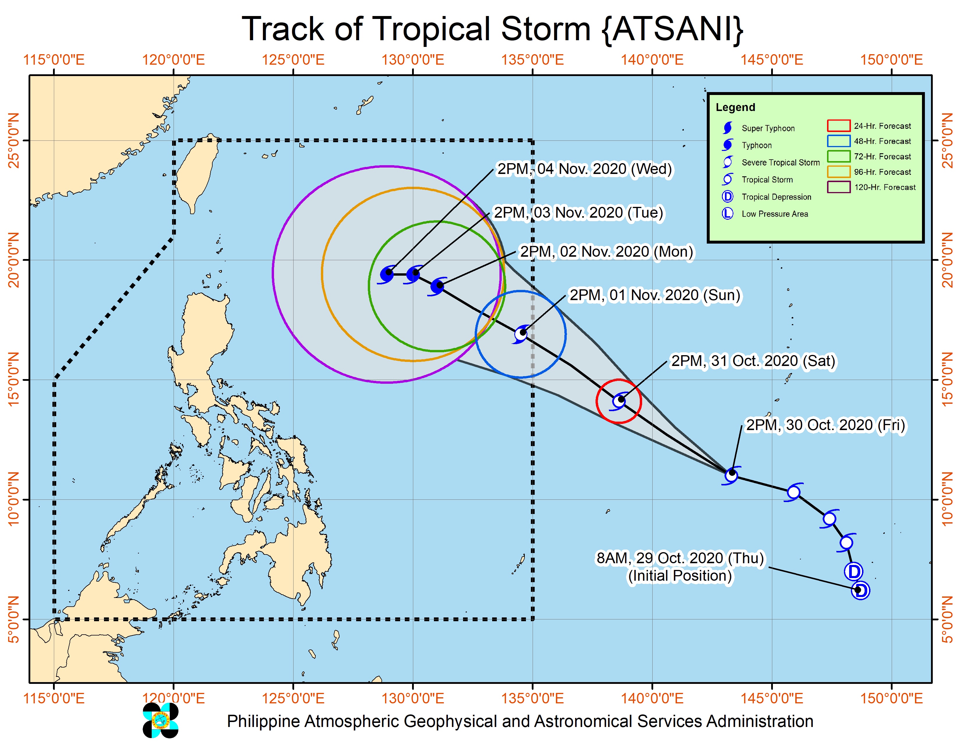
Aside from Rolly, PAGASA continues to monitor Tropical Storm Atsani, located outside PAR at 1,865 kilometers east of the Visayas.
Atsani is still moving west northwest at a relatively fast 35 km/h, and could enter PAR on Sunday or Monday. Once it enters, it will be given the local name Siony. (READ: LIST: PAGASA’s names for tropical cyclones in 2020)
Atsani maintained its strength, with maximum sustained winds of 65 km/h and gustiness of up to 80 km/h. But PAGASA said it is forecast to intensify into a severe tropical storm in the next 24 to 36 hours.
At least for the next 3 days, Atsani or the potential Siony is unlikely to have a severe impact on any part of the country, according to PAGASA.
Rolly is the Philippines’ 18th tropical cyclone for 2020, while Siony would be the 19th. Rolly is also the 5th tropical cyclone for October alone.
An average of 20 tropical cyclones form within or enter PAR each year.
These are PAGASA’s latest estimates for the number of tropical cyclones inside PAR in the next 6 months:
- November 2020 – 1 to 3
- December 2020 – 2 or 3
- January 2021 – 0 or 1
- February 2021 – 0 or 1
- March 2021 – 0 or 1
- April 2021 – 0 or 1
Last October 2, the state weather bureau warned Filipinos to expect more rain in the coming months due to the onset of La Niña. – Rappler.com
Add a comment
How does this make you feel?


There are no comments yet. Add your comment to start the conversation.