SUMMARY
This is AI generated summarization, which may have errors. For context, always refer to the full article.
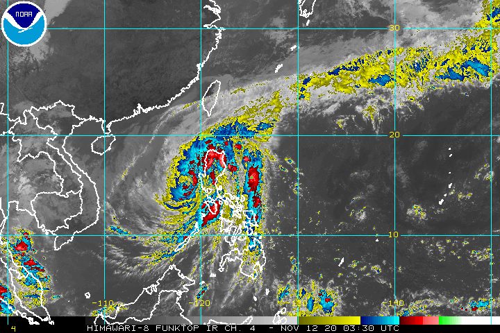
After leaving massive floods in parts of Luzon, Typhoon Ulysses (Vamco) is now over the West Philippine Sea.
The Philippine Atmospheric, Geophysical, and Astronomical Services Administration (PAGASA) said in an online briefing past 11 am on Thursday, November 12, that Ulysses is already 85 kilometers west of Iba, Zambales.
The typhoon’s center emerged over the western seaboard of Zambales at 8 am.
It slightly slowed down and is now moving west at 25 kilometers per hour (km/h) from the previous 30 km/h. (READ: FAST FACTS: Tropical cyclones, rainfall advisories)
Ulysses maintained its strength, with maximum sustained winds of 130 km/h, while its gustiness further decreased from 215 km/h to 200 km/h. But PAGASA said the typhoon may slightly intensify over the West Philippine Sea as it continues to move away from land.
Though Ulysses is already moving away, however, it could still trigger more rain for the rest of Thursday.
Until Thursday afternoon, November 12
Heavy to intense rain, with at times torrential rain
- Zambales
- Bataan
- Pampanga
- Tarlac
Moderate to heavy rain, with at times intense rain
- Cordillera Administrative Region
- mainland Cagayan Valley
- Babuyan Islands
- Calabarzon
- Metro Manila
- Oriental Mindoro
- Occidental Mindoro
- Marinduque
- rest of Central Luzon
Light to moderate rain, with at times heavy rain
- rest of Luzon
- Visayas
Between Thursday afternoon and evening, November 12
Moderate to heavy rain
- Cordillera Administrative Region
- eastern part of Cagayan
- eastern part of Isabela
- Zambales
- Bataan
- Aurora
- Metro Manila
- Cavite
- western part of Batangas
- northern part of Occidental Mindoro including Lubang Island
Light to moderate rain, with at times heavy rain
- rest of Luzon
- Western Visayas
Many areas in Luzon remain under tropical cyclone wind signals as of 11 am on Thursday. Metro Manila has been downgraded to Signal No. 2.
Signal No. 3 (destructive typhoon-force winds)
- western part of Pangasinan (Bayambang, Bautista, Alcala, Santo Tomas, Malasiqui, Santa Barbara, Mangaldan, Dagupan City, Basista, San Carlos City, Calasiao, Binmaley, Urbiztondo, Mangatarem, Aguilar, Bugallon, Lingayen, Labrador, Infanta, Mabini, Sual, Dasol, Burgos, Alaminos City, Agno, Bani, Bolinao, Anda)
- Zambales
- Bataan
- Tarlac
- Pampanga
Signal No. 2 (damaging gale- to storm-force winds)
- central and southern parts of Isabela (Mallig, Quirino, Ilagan, Roxas, Burgos, Gamu, Palanan, San Mariano, Dinapigue, San Guillermo, Benito Soliven, Naguilian, Reina Mercedes, Luna, San Manuel, Aurora, Cabatuan, Cauayan City, San Mateo, Alicia, Angadanan, Echague, Jones, San Agustin, San Isidro, Ramon, Santiago City, Cordon)
- Quirino
- Nueva Vizcaya
- Mountain Province
- Ifugao
- Benguet
- southern part of Ilocos Sur (Cervantes, Quirino, San Emilio, Lidlidda, Santiago, Banayoyo, Candon City, Galimuyod, Gregorio Del Pilar, Salcedo, Santa Lucia, Santa Cruz, Sigay, Suyo, Tagudin, Alilem, Sugpon)
- La Union
- rest of Pangasinan
- Aurora
- Nueva Ecija
- Bulacan
- Metro Manila
- Cavite
- Rizal
- Laguna
- Batangas
- northern and western parts of Quezon (Mauban, Pagbilao, Tayabas City, Lucena City, Sariaya, Candelaria, San Antonio, Tiaong, Dolores, Lucban, Sampaloc, Real, Infanta, General Nakar) including Polillo Island
- northwestern part of Oriental Mindoro (Puerto Galera, San Teodoro)
- northwestern part of Occidental Mindoro (Paluan, Abra de Ilog) including Lubang Island
Signal No. 1 (strong breeze to near gale conditions)
- rest of Isabela
- Kalinga
- Abra
- rest of Ilocos Sur
- rest of northern part of Oriental Mindoro (Baco, Calapan City, Naujan, Victoria, Pola)
- rest of northern part of Occidental Mindoro (Mamburao, Santa Cruz)
- central part of Quezon (Gumaca, Macalelon, Pitogo, Unisan, Agdangan, Plaridel, Atimonan, Padre Burgos, Quezon, Alabat, Perez)
In the rest of Northern Luzon, there are strong breeze to gale-force winds due to the surge of the northeast monsoon or hanging amihan.
PAGASA’s storm surge warning remains in effect, too, with “life-threatening and damaging coastal inundation” possible.
Up to 3 meters high
- coastal areas of Aurora, northern Quezon including Polillo Island, Cavite, Metro Manila, Bulacan, Pampanga, Bataan, and Zambales
Up to 2 meters high
- coastal areas of Isabela, La Union, Pangasinan, Batangas, rest of Quezon, Marinduque, and northern parts of Oriental Mindoro and Occidental Mindoro including Lubang Island
“Moreover, there is also a moderate risk of seiche or storm surge over the coastal areas surrounding Laguna de Bay,” PAGASA said.
Within the next 24 hours, Ulysses and the surge of the northeast monsoon combined will make travel risky for all types of vessels in certain seaboards.
Rough to very high seas (waves 2.5 to 10 meters high)
- seaboards of areas under Signal Nos. 1, 2, and 3
- northern seaboard of Northern Samar
Rough to high seas (waves 3 to 6 meters high)
- remaining seaboards of Northern Luzon
Rough to very rough seas (waves 2.5 to 4.5 meters high)
- western seaboard of Palawan including Calamian and Kalayaan Islands
- seaboards of Romblon and Bicol not under tropical cyclone wind signals
Meanwhile, waters are moderate to rough, with waves 1.5 to 2.5 meters high in the seaboards below. Small vessels must take precautionary measures.
- eastern seaboards of Visayas and Mindanao
- seaboards of Cuyo Islands
- western seaboard of Panay Island
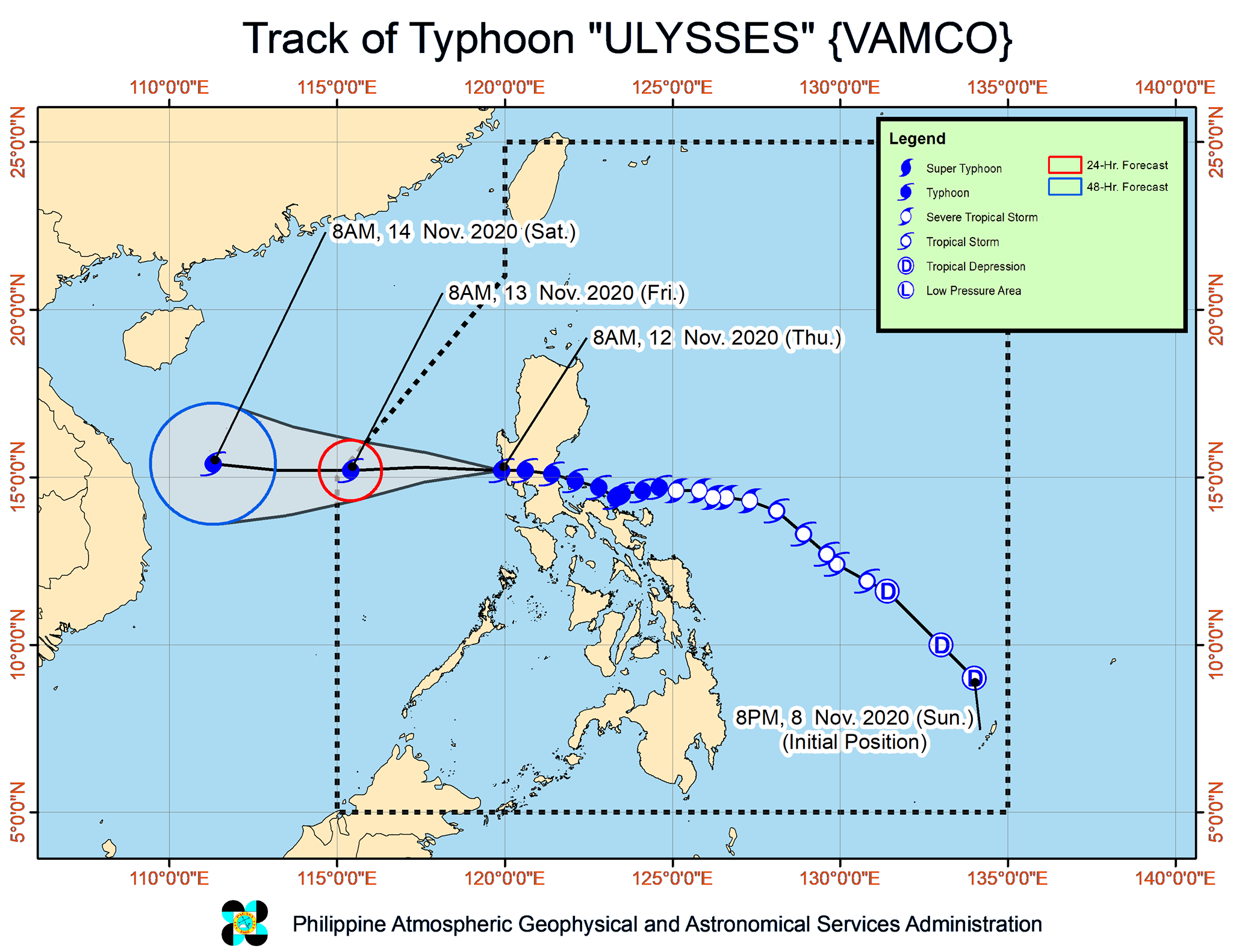
Before crossing Central Luzon in the early hours of Thursday, Ulysses made landfall thrice in Quezon province.
- Patnanungan – 10:30 pm on Wednesday, November 11
- Burdeos – 11:20 pm on Wednesday, November 11
- General Nakar – 1:40 am on Thursday, November 12
Even before the typhoon hit Quezon and Central Luzon, it passed very close to Bicol, leaving at least one person dead and causing massive floods in the region.
As Ulysses crossed Central Luzon, Metro Manila and Calabarzon also felt the wrath of the typhoon.
In Marikina City, as the Marikina River’s water level rose, residents were reminded of the deadly onslaught of Tropical Storm Ondoy (Ketsana) in September 2009. (READ: Air rescue needed: Thousands of Marikina houses submerged in roof-level floods)
Rizal province was also badly affected, with residents fleeing their homes due to rising floods.
Ulysses is expected to leave the Philippine Area of Responsibility (PAR) on Friday morning, November 13.
Ulysses is the Philippines’ 21st tropical cyclone for 2020 – already above the yearly average of 20. (READ: LIST: PAGASA’s names for tropical cyclones in 2020)
For the next 6 months, these are PAGASA’s estimates for tropical cyclones inside PAR:
- November 2020 – 1 to 3
- December 2020 – 2 or 3
- January 2021 – 0 or 1
- February 2021 – 0 or 1
- March 2021 – 0 or 1
- April 2021 – 0 or 1
Since October, La Niña has been underway, which means there is more rain than usual.
Then in November, the northeast monsoon began, signaling “surges of cold temperatures.”
PAGASA warned that La Niña may enhance the northeast monsoon, which could trigger floods and landslides. – Rappler.com
Add a comment
How does this make you feel?


There are no comments yet. Add your comment to start the conversation.