SUMMARY
This is AI generated summarization, which may have errors. For context, always refer to the full article.
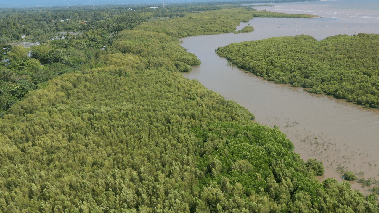
MANILA, Philippines – The Geospatial Database Office (GDO) of the Department of Environment and Natural Resources (DENR) has found little progress in selected National Greening Program (NGP) mangrove rehabilitation sites when they compared historical satellite images to 2022 photos.
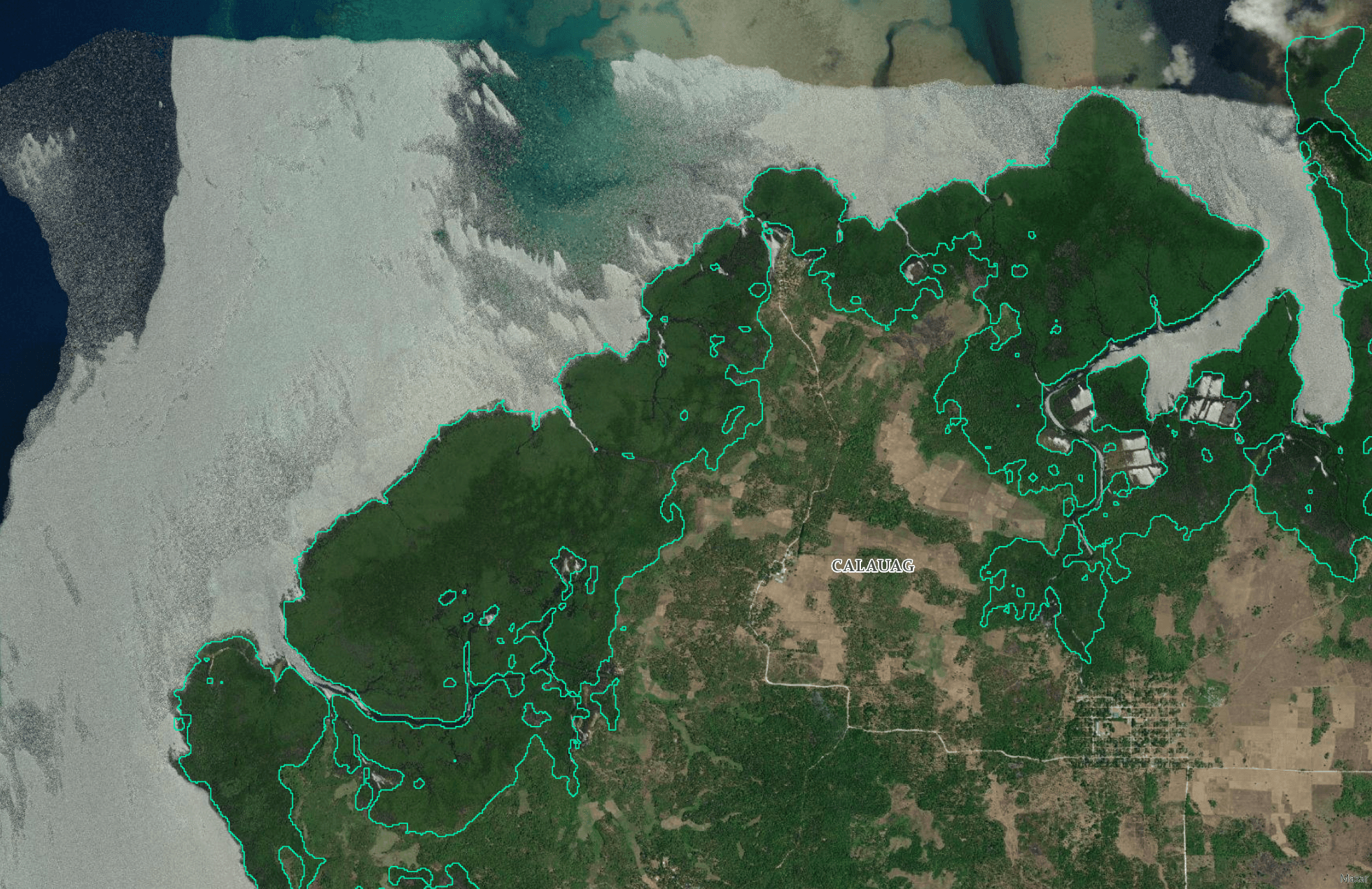
Reforestation efforts in mangrove sites in Calauag, Quezon province, for example, started in 2013. But seven years later, satellite images show empty patches where mangroves should have already grown. It’s the same scenario in other NGP sites in Pampanga, Eastern Samar, and Pangasinan.
Agatha Bedi, an ecologist in the GDO specializing in coastal ecosystems, used satellite images, DENR’s maps of NGP sites, and the mangrove map from the National Mapping and Resource Information Authority, for this initiative.
“There’s a lot of available information out there, but no one’s collecting and analyzing,” said Bedi in a mix of Filipino and English during an office visit.
Bedi told Rappler that the DENR already informed regional directors about the NGP results last year.
In the same year, the DENR partnered with the Philippine Space Agency (PhilSA) and produced the National Mangrove Map 2023 using remotely sensed images taken from the European Space Agency’s imaging mission Sentinel-2 and Japan Aerospace Exploration Agency’s ALOS PALSAR2.
Bedi said that while these still need validation from the ground, the images are already representative of what’s on the ground.
“The National Mangrove Map 2023, once ground-truthed this year, will help our initiatives to analyze the NGP results, and identify and monitor specific areas for science-based mangrove rehabilitation in the country,” she said.
The environment department has ordered regional offices to conduct field validation and report back within two months. The DENR also encouraged the offices to partner with the academe, non-government organizations, and volunteers.
An increasing awareness of mangroves had amplified its role in coastal protection and as crucial habitat for wildlife. Mangroves are also vital in the fight against climate change as they capture carbon emissions four times more than rainforests.
Failure in NGP
When the government established the NGP in 2011, it envisioned a program that could both target poverty and the degradation of Philippine forests.
The DENR, together with the Department of Agriculture and the Department of Agrarian Reform, carries the huge responsibility of ensuring a greener Philippine landscape.
The Forest Management Bureau (FMB) gauged success by the number of seedlings planted and jobs provided. It reported 60.4 million seedlings planted in 2021. Around 5.6 million jobs were created from 2011 to 2022.
But the recent satellite images of mangrove covers say otherwise.
Mangrove expert Jurgenne Primavera said among the common reasons why the mangroves are not flourishing are the use of the wrong species and/or planting in the wrong zones.
Often planted in NGP sites is the Rhizophora or bakhaw. But there are other types of mangroves like bungalon (Avecennia marina) and pagatpat (Sonneratia alba) that could be more resilient.
“Just with the site selection, we should already be checking the tidal elevation because mangroves should be in the middle and upper intertidal,” explained Primavera in a mix of Filipino and English. “Many of the NGP [initiatives] plant at the lower intertidal.”
Planting at the lower intertidal would drown the mangrove seedlings during high tide.
Other reasons, according to Primavera, are the wrong measurement for success and lack of monitoring. Primavera said that success of NGP sites is based on the number of seedlings planted. But what happens after planting season? Do we know?
“Kung maraming matatanim, maraming pera,” said Primavera. “Ang driver ay not science, pero pera.” (There’s a lot of money if a lot of seedlings are planted. The driving motivation is not science, but money.)
“Whereas science demands survival,” the marine scientist said.
If there is a good site for mangrove reforestation, it would have to be abandoned fishponds.
Under the Fisheries Administrative Order No. 197-1, the Bureau of Fisheries and Aquatic Resources (BFAR) should revert abandoned or underdeveloped fishponds back to the stewardship of the DENR for mangrove restoration.
Primavera said the government should focus on putting more resources in restoring these abandoned fishponds into mangroves.
“Abandoned fishponds are where mangroves used to be,” said Primavera. “They cleared the forests, dug holes. These became the fishponds.”
Environment Undersecretary Carlos Primo David told Rappler they are very much willing to restore the mangrove forests, if and when BFAR reverts back these fishponds to the DENR.
Why map?
A mangrove map is the first step towards better governance of the country’s natural resources.
Using satellite data, David said, helps them “disburse the management of the environment remotely.”
David heads the GDO staff which have their hands full mapping the country’s freshwater resources, identifying industries without environmental compliance certificates, among others.
The mangrove mapping initiative helps the DENR and its regional offices as well as local governments determine where to focus conservation efforts. According to David, the next step is to identify places where there should be mangroves.
David said there were some areas they saw that are near mangrove forests and have the same conditions. These are places that should have mangroves, or had mangroves before.
DENR Secretary Toni Yulo-Loyzaga lauded the National Mangrove Map 2023 as a “milestone.”
“With the help of our partner agencies and academic community, and non-government organizations, we reiterate the DENR’s firm commitment to establish natural capital accounts which equals integrating key ecosystems like mangrove forests into building a sustainable and thriving blue economy for the country,” Loyzaga said in her speech during the launch in February. – Rappler.com
Add a comment
How does this make you feel?


![[OPINION] Grading Marcos admin’s performance on the climate agenda](https://www.rappler.com/tachyon/2024/06/grading-marcos-performance-climate-agenda-june-25-2025.jpg?resize=257%2C257&crop=441px%2C0px%2C1080px%2C1080px)
There are no comments yet. Add your comment to start the conversation.