SUMMARY
This is AI generated summarization, which may have errors. For context, always refer to the full article.
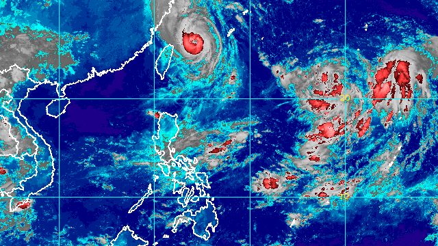
MANILA, Philippines – Typhoon Inday (Muifa) left the Philippine Area of Responsibility (PAR) at 12:40 am on Tuesday, September 13, more than five days since its entry as a tropical storm.
Inday was last spotted 560 kilometers north northeast of Itbayat, Batanes, already over the East China Sea, the Philippine Atmospheric, Geophysical, and Astronomical Services Administration (PAGASA) said in its 5 am bulletin on Tuesday.
The typhoon is slowly moving north northeast, heading for the east coast of China, where it could eventually make landfall in Shanghai or Zhejiang.
As of early Tuesday, Inday had maximum sustained winds of 140 kilometers per hour and gustiness of up to 170 km/h.
PAGASA said gusty conditions may persist in extreme Northern Luzon on Tuesday and Wednesday, September 14, “due to the channeling of the typhoon circulation in the Luzon Strait.”
Inside PAR, Inday’s maximum sustained winds had peaked at 165 km/h. But the typhoon stayed away from Philippine landmass and tropical cyclone wind signals were not raised.
Inday’s trough or extension only brought scattered rain showers and thunderstorms to parts of Luzon and the Visayas. The typhoon also briefly enhanced the southwest monsoon or hanging habagat.
Despite Inday’s exit from PAR, a gale warning was still issued for the seaboards of Batanes and Babuyan Islands at 5 am on Tuesday.
PAGASA said seas remain rough to very rough, with waves 2.8 to 4.5 meters high.
The weather bureau advised fishing boats and other small vessels not to sail, and larger vessels to watch out for big waves.
Inday was the Philippines’ ninth tropical cyclone for 2022 and the first for September.

After Inday, PAGASA is monitoring a tropical depression outside PAR.
The tropical depression was located 1,720 kilometers east of extreme Northern Luzon before dawn on Tuesday, slowly moving east over the Philippine Sea.
It has maximum sustained winds of 45 km/h and gustiness of up to 55 km/h.
PAGASA said the tropical depression is expected to drift east northeast or become almost stationary for the next 36 hours before “sharply turning” northwest or west northwest on Thursday, September 15, as it speeds up.
At that pace, it could enter PAR on Thursday afternoon or evening, and would be given the local name Josie.
By the time it enters PAR, it may already be a typhoon. PAGASA said “modest intensification is likely” on Tuesday and Wednesday, while “improving environmental conditions will enable the tropical cyclone to intensify at a relatively faster rate” by Thursday.
The potential Josie is not expected to make landfall in the Philippines. It will not directly affect weather in the country.
But PAGASA said it may enhance the southwest monsoon, which could bring monsoon rain to the western parts of Southern Luzon and the Visayas beginning Wednesday or Thursday.

PAGASA expects 7 to 11 tropical cyclones to enter or develop inside PAR from September 2022 to February 2023. Per month, these are the weather bureau’s estimates:
- September 2022 – 2 or 3
- October 2022 – 2 to 4
- November 2022 – 2 or 3
- December 2022 – 1 or 2
- January 2023 – 0 or 1
- February 2023 – 0 or 1
– Rappler.com
Add a comment
How does this make you feel?


There are no comments yet. Add your comment to start the conversation.