SUMMARY
This is AI generated summarization, which may have errors. For context, always refer to the full article.
What’s the weather like in your area? Tweet us at @rapplerdotcom.
MANILA, Philippines – State forecasters no longer expect the powerful Typhoon Hagibis to enter the Philippine Area of Responsibility (PAR).
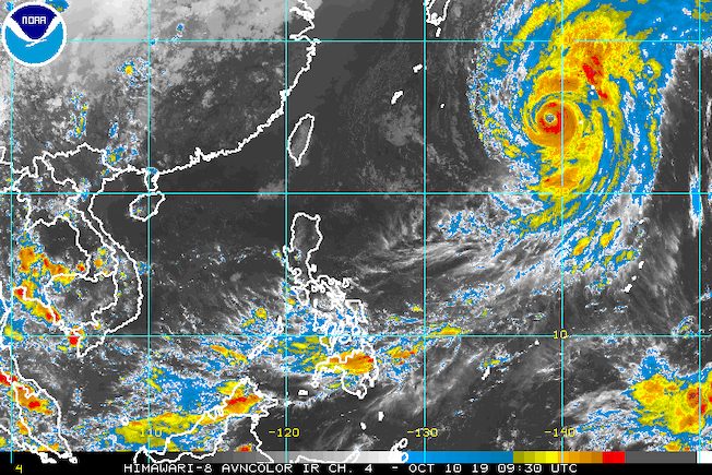
In a briefing at 4 pm on Thursday, October 10, the Philippine Atmospheric, Geophysical, and Astronomical Services Administration (PAGASA) said Hagibis is already 1,835 kilometers east northeast of Basco, Batanes.
The typhoon is moving north northwest at 25 kilometers per hour (km/h), heading for Japan. It was previously expected to enter PAR by Friday, October 11.
PAGASA said Hagibis could make landfall in Japan’s eastern Chubu-western Kanto region between Saturday evening, October 12, and early Sunday morning, October 13.
The typhoon continues to have maximum winds of 200 km/h and gustiness of up to 245 km/h. (READ: FAST FACTS: Tropical cyclones, rainfall advisories)
While Hagibis is not seen to enter PAR, PAGASA Weather Specialist Gener Quitlong said the typhoon’s trough or extension will affect the Visayas and Mindanao.
Scattered rainshowers and thunderstorms due to Hagibis’ trough are expected in the following areas in the next 24 hours:
- Visayas
- Caraga
- Davao Region
- Northern Mindanao
- Zamboanga Peninsula
The rest of the country will have fair weather, with only isolated rainshowers or thunderstorms, typically in the afternoon or evening.
The Philippines has had 15 tropical cyclones in 2019. (READ: LIST: PAGASA’s names for tropical cyclones in 2019)
The country gets an average of 20 tropical cyclones annually, but since 2019 is an El Niño year, only 14 to 18 tropical cyclones are expected.
Below is the estimated number of tropical cyclones from October to December:
- October – 2 or 3
- November – 1 or 2
- December – 0 or 1
PAGASA declared the start of the rainy season last June 14. – Rappler.com
Add a comment
How does this make you feel?


There are no comments yet. Add your comment to start the conversation.